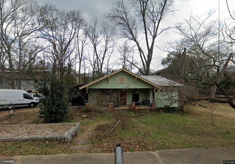
480 Ruth St Athens, GA 30601
North Avenue NeighborhoodEstimated Value: $275,000 - $323,000
--
Bed
--
Bath
1,471
Sq Ft
$201/Sq Ft
Est. Value
About This Home
This home is located at 480 Ruth St, Athens, GA 30601 and is currently estimated at $295,778, approximately $201 per square foot. 480 Ruth St is a home located in Clarke County with nearby schools including Howard B. Stroud Elementary School, Coile Middle School, and Cedar Shoals High School.
Ownership History
Date
Name
Owned For
Owner Type
Purchase Details
Closed on
Jan 18, 2023
Sold by
Caspary Melissa D
Bought by
Caspary Melissa D and Poucher Mark
Current Estimated Value
Purchase Details
Closed on
Jul 21, 2002
Sold by
Baker Developers Inc
Bought by
Caspary Melissa D and Foucher Mark C
Purchase Details
Closed on
Aug 3, 2001
Sold by
Hall Gregory S and Hall Connie B
Bought by
Baker Developers Inc
Purchase Details
Closed on
Jun 7, 1996
Sold by
Baker Developers Inc
Bought by
Hall Gregory S and Hall Connie B
Purchase Details
Closed on
Nov 9, 1990
Sold by
Baker Leo R
Bought by
Baker Developers Inc
Purchase Details
Closed on
Oct 26, 1989
Sold by
Bradford Helen
Bought by
Baker Leo R
Create a Home Valuation Report for This Property
The Home Valuation Report is an in-depth analysis detailing your home's value as well as a comparison with similar homes in the area
Home Values in the Area
Average Home Value in this Area
Purchase History
| Date | Buyer | Sale Price | Title Company |
|---|---|---|---|
| Caspary Melissa D | -- | -- | |
| Caspary Melissa D | $72,500 | -- | |
| Baker Developers Inc | $44,000 | -- | |
| Hall Gregory S | $35,000 | -- | |
| Baker Developers Inc | -- | -- | |
| Baker Leo R | $12,000 | -- |
Source: Public Records
Tax History Compared to Growth
Tax History
| Year | Tax Paid | Tax Assessment Tax Assessment Total Assessment is a certain percentage of the fair market value that is determined by local assessors to be the total taxable value of land and additions on the property. | Land | Improvement |
|---|---|---|---|---|
| 2025 | $2,834 | $108,564 | $18,000 | $90,564 |
| 2024 | $2,834 | $105,080 | $18,000 | $87,080 |
| 2023 | $1,878 | $95,094 | $18,000 | $77,094 |
| 2022 | $2,089 | $75,472 | $14,000 | $61,472 |
| 2021 | $1,729 | $61,308 | $12,000 | $49,308 |
| 2020 | $1,519 | $55,072 | $11,200 | $43,872 |
| 2019 | $1,352 | $49,831 | $11,200 | $38,631 |
| 2018 | $1,299 | $48,254 | $10,400 | $37,854 |
| 2017 | $963 | $38,354 | $10,400 | $27,954 |
| 2016 | $936 | $37,577 | $10,400 | $27,177 |
| 2015 | $938 | $37,577 | $10,400 | $27,177 |
| 2014 | $940 | $37,578 | $10,400 | $27,178 |
Source: Public Records
Map
Nearby Homes
- 464 Ruth St
- 175 Northcrest Dr
- 211 North Ave Unit 1333
- 455 Ruth St
- 136 Bridgewater Cir
- 118 Ruth Dr Unit 130
- 118 Ruth Dr Unit 140
- 118 Ruth Dr Unit 310
- 118 Ruth Dr Unit 610
- 239 Ruth St Unit 15
- 239 Madison Heights
- 560 Rosa Nell Howard St
- 495 Boley Dr
- 320 First St
- 318 First St
- 192 Sunny Hills Dr
- 185 First St
- 178 First St