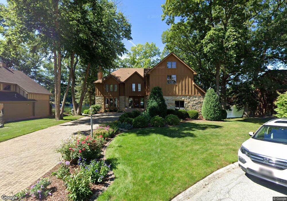
480 Scarborough Rd Valparaiso, IN 46385
Porter County NeighborhoodEstimated Value: $873,000 - $978,608
4
Beds
5
Baths
3,834
Sq Ft
$241/Sq Ft
Est. Value
About This Home
This home is located at 480 Scarborough Rd, Valparaiso, IN 46385 and is currently estimated at $925,804, approximately $241 per square foot. 480 Scarborough Rd is a home located in Porter County with nearby schools including Union Township Middle School and Wheeler High School.
Ownership History
Date
Name
Owned For
Owner Type
Purchase Details
Closed on
Jan 17, 2025
Sold by
Luedtke Kevin
Bought by
Alex Ghobad Heidari Revocable Living Trust and Heidari
Current Estimated Value
Purchase Details
Closed on
Jul 25, 2023
Sold by
Sharon Porapaiboon Living Trust
Bought by
Luedtke Kevin
Purchase Details
Closed on
Dec 22, 2006
Sold by
Porapaiboon Veera and Porapaiboon Sharon
Bought by
Porapaiboon Veera and Porapaiboon Sharon
Create a Home Valuation Report for This Property
The Home Valuation Report is an in-depth analysis detailing your home's value as well as a comparison with similar homes in the area
Home Values in the Area
Average Home Value in this Area
Purchase History
| Date | Buyer | Sale Price | Title Company |
|---|---|---|---|
| Alex Ghobad Heidari Revocable Living Trust | -- | Chicago Title | |
| Luedtke Kevin | -- | None Listed On Document | |
| Porapaiboon Veera | -- | None Available |
Source: Public Records
Tax History Compared to Growth
Tax History
| Year | Tax Paid | Tax Assessment Tax Assessment Total Assessment is a certain percentage of the fair market value that is determined by local assessors to be the total taxable value of land and additions on the property. | Land | Improvement |
|---|---|---|---|---|
| 2024 | $8,078 | $1,046,900 | $99,400 | $947,500 |
| 2023 | $8,078 | $953,200 | $97,000 | $856,200 |
| 2022 | $7,625 | $864,600 | $97,000 | $767,600 |
| 2021 | $7,425 | $818,700 | $97,000 | $721,700 |
| 2020 | $6,551 | $716,000 | $88,100 | $627,900 |
| 2019 | $6,183 | $674,100 | $88,100 | $586,000 |
| 2018 | $6,737 | $674,100 | $88,100 | $586,000 |
| 2017 | $6,297 | $697,400 | $88,100 | $609,300 |
| 2016 | $5,459 | $616,100 | $110,000 | $506,100 |
| 2014 | $5,613 | $596,200 | $106,100 | $490,100 |
| 2013 | -- | $528,800 | $100,700 | $428,100 |
Source: Public Records
Map
Nearby Homes
- 459 Surrey Hill Ln
- 459 Amhurst Rd
- 447 Scarborough Rd
- 446 Surrey Hill Ln
- 464 Roxbury Rd
- 460 Roxbury Rd
- 194 Wexford Rd
- 483 Roxbury Rd
- 454 Roxbury Rd
- 175 Shorewood Dr
- 419 Scarborough Rd
- 220 N 500 W
- 397 Shorewood Ct
- 246 Pixley Ct
- 149 Westchester Ln
- 536 W Us Highway 30
- 143 N 500 W
- 148 Timber Point Ct
- 1950 St Road 130
- 122 Shorewood Dr
- 478 Scarborough Rd
- 482 Scarborough Rd
- 476 Scarborough Rd
- 475 Scarborough Rd
- 481 Scarborough Rd
- 477 Scarborough Rd
- 473 Scarborough Rd
- 479 Scarborough Rd
- 474 Scarborough Rd
- 471 Scarborough Rd
- 472 Scarborough Rd
- 469 Scarborough Rd
- 470 Scarborough Rd
- 464 Wexford Rd
- 462 Wexford Rd
- 468 Wexford Rd
- 191 Amhurst Place
- 470 Wexford Rd
- 206 Scarborough Ct
- 472 Wexford Rd