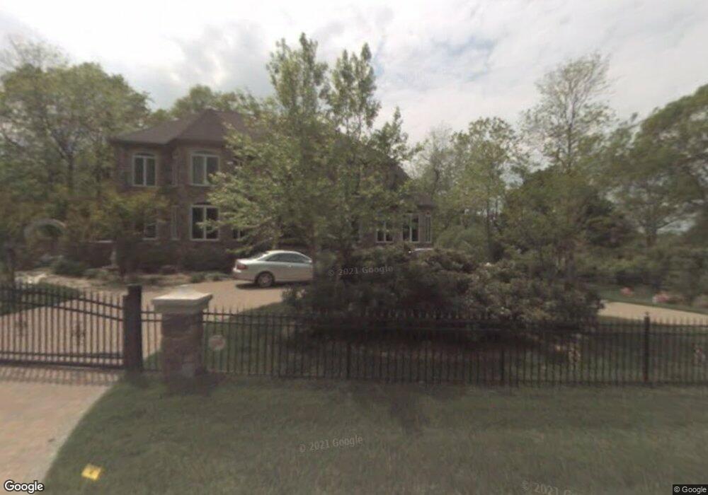
4800 Westward View Rd Shady Side, MD 20764
Estimated Value: $1,308,000 - $2,541,819
Studio
4
Baths
6,859
Sq Ft
$292/Sq Ft
Est. Value
About This Home
This home is located at 4800 Westward View Rd, Shady Side, MD 20764 and is currently estimated at $2,002,273, approximately $291 per square foot. 4800 Westward View Rd is a home located in Anne Arundel County with nearby schools including Shady Side Elementary School, Southern Middle School, and Southern High School.
Ownership History
Date
Name
Owned For
Owner Type
Purchase Details
Closed on
Jan 23, 2020
Sold by
Kasap Matt and Kasap Matt A
Bought by
Kasap A Matt and A Matt Kasap Revocable Living
Current Estimated Value
Purchase Details
Closed on
Jun 19, 2000
Sold by
West River Holding Co
Bought by
Kasap Matt
Purchase Details
Closed on
Mar 12, 1999
Sold by
Chidakel Family Trust
Bought by
West River Holding Co
Create a Home Valuation Report for This Property
The Home Valuation Report is an in-depth analysis detailing your home's value as well as a comparison with similar homes in the area
Home Values in the Area
Average Home Value in this Area
Purchase History
| Date | Buyer | Sale Price | Title Company |
|---|---|---|---|
| Kasap A Matt | -- | None Available | |
| Kasap Matt | $275,000 | -- | |
| West River Holding Co | $312,500 | -- |
Source: Public Records
Mortgage History
| Date | Status | Borrower | Loan Amount |
|---|---|---|---|
| Closed | West River Holding Co | -- |
Source: Public Records
Tax History
| Year | Tax Paid | Tax Assessment Tax Assessment Total Assessment is a certain percentage of the fair market value that is determined by local assessors to be the total taxable value of land and additions on the property. | Land | Improvement |
|---|---|---|---|---|
| 2025 | $20,239 | $2,185,067 | -- | -- |
| 2024 | $20,239 | $1,987,233 | $0 | $0 |
| 2023 | $19,614 | $1,789,400 | $400,900 | $1,388,500 |
| 2022 | $18,206 | $1,742,167 | $0 | $0 |
| 2021 | $0 | $1,694,933 | $0 | $0 |
| 2020 | $0 | $1,647,700 | $400,900 | $1,246,800 |
| 2019 | $0 | $1,647,700 | $400,900 | $1,246,800 |
| 2018 | $16,708 | $1,647,700 | $400,900 | $1,246,800 |
| 2017 | $17,914 | $1,753,900 | $0 | $0 |
| 2016 | $65 | $1,715,833 | $0 | $0 |
| 2015 | $65 | $1,677,767 | $0 | $0 |
| 2014 | -- | $1,639,700 | $0 | $0 |
Source: Public Records
Map
Nearby Homes
- 1268 Hayes Rd
- 1161 Steamboat Rd
- 4907 Quince St
- 1209 Johnson Dr
- 1241 Steamboat Rd
- 1340 E West Shady Side Rd
- 1205 Avalon Blvd
- 1379 McDonald Rd
- 1225 Juniper St
- 4908 Aspen St
- 0 Riverside Dr Unit BOATSLIP C21
- 1237A Juniper St
- 4951 Dogwood St
- 4846 Woods Wharf Rd
- 1462 Snug Harbor Rd
- 1306 Spruce St
- Lot 2 Benning Rd
- 1330 Jordan Dr
- 1419 Shady Rest Rd
- 946 Benning Rd
- 4802 Westward View Rd
- 1200 Hayes Rd
- 1212 Hayes Rd
- 1206 Hayes Rd
- 1210 Hayes Rd
- 1218 Hayes Rd
- 1218 Hayes Rd Unit 1218
- 4804 Westward View Rd
- 1222 Hayes Rd
- 4806 Westward View Rd
- 1228 Hayes Rd
- 6548 Shady Side Rd
- 6522 Shady Side Rd
- 6522 W Shady Side Rd
- 6558 Shady Side Rd
- 6520 Hunter Rd
- 6519 Shady Side Rd
- 6547 Shady Side Rd
- 6547 W Shady Side Rd
- 6524 Hunter Rd
Your Personal Tour Guide
Ask me questions while you tour the home.