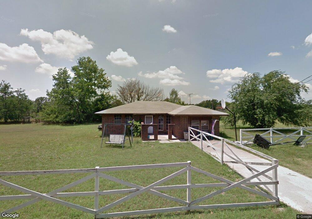
4801 Martin Dr Harrah, OK 73045
Edendale Estates-Newalla NeighborhoodEstimated Value: $187,000 - $236,000
2
Beds
1
Bath
1,287
Sq Ft
$159/Sq Ft
Est. Value
About This Home
This home is located at 4801 Martin Dr, Harrah, OK 73045 and is currently estimated at $204,487, approximately $158 per square foot. 4801 Martin Dr is a home located in Oklahoma County with nearby schools including Anna May Daulton Elementary School, Louise Cabaniss Elementary School, and Cora Spencer Elementary School.
Ownership History
Date
Name
Owned For
Owner Type
Purchase Details
Closed on
Jul 2, 2008
Sold by
Lynch Bonnie F
Bought by
Craig Timothy R and Craig Anna E
Current Estimated Value
Home Financials for this Owner
Home Financials are based on the most recent Mortgage that was taken out on this home.
Original Mortgage
$87,351
Interest Rate
6.09%
Mortgage Type
Purchase Money Mortgage
Create a Home Valuation Report for This Property
The Home Valuation Report is an in-depth analysis detailing your home's value as well as a comparison with similar homes in the area
Home Values in the Area
Average Home Value in this Area
Purchase History
| Date | Buyer | Sale Price | Title Company |
|---|---|---|---|
| Craig Timothy R | $84,000 | First American Title & Tr Co |
Source: Public Records
Mortgage History
| Date | Status | Borrower | Loan Amount |
|---|---|---|---|
| Closed | Craig Timothy R | $87,351 |
Source: Public Records
Tax History Compared to Growth
Tax History
| Year | Tax Paid | Tax Assessment Tax Assessment Total Assessment is a certain percentage of the fair market value that is determined by local assessors to be the total taxable value of land and additions on the property. | Land | Improvement |
|---|---|---|---|---|
| 2024 | $1,502 | $16,115 | $3,298 | $12,817 |
| 2023 | $1,502 | $15,347 | $3,539 | $11,808 |
| 2022 | $1,454 | $14,617 | $1,099 | $13,518 |
| 2021 | $1,385 | $13,920 | $1,213 | $12,707 |
| 2020 | $1,355 | $13,258 | $1,263 | $11,995 |
| 2019 | $1,288 | $12,627 | $1,170 | $11,457 |
| 2018 | $1,250 | $12,026 | $0 | $0 |
| 2017 | $1,167 | $11,452 | $845 | $10,607 |
| 2016 | $1,131 | $10,908 | $830 | $10,078 |
| 2015 | $1,067 | $10,388 | $962 | $9,426 |
| 2014 | $1,112 | $10,855 | $1,813 | $9,042 |
Source: Public Records
Map
Nearby Homes
- 4600 S Harrah Rd
- 21094 River Mist Dr
- 3816 Ada Ave
- 3881 River Mist Lake Dr
- 21086 River Mist Dr
- RC Wright Plan at River Mist
- RC Carnegie II Plan at River Mist
- RC Kinsley II Plan at River Mist
- RC Lowell II Plan at River Mist
- RC Coleman Plan at River Mist
- RC Raleigh Plan at River Mist
- RC Foster II Plan at River Mist
- 4353 Titan Terrace
- 4332 Titan Terrace
- 3600 S Harrah Rd
- 3833 Dove Ave
- 21097 Rivermist Dr
- 0 Halifax St
- 3880 Louthea Ln
- 3888 Ada Ave
- 4705 Martin Dr
- 4700 Martin Dr
- 20634 SE 48th St
- 4901 Pond Dr
- 4735 Pond Dr
- 20636 SE 48th St
- 4663 Pond Dr
- 4987 Pond Dr
- 4601 Pond Dr
- 20700 SE 48th St
- 5105 Pond Dr
- 5050 Pond Dr
- 20600 SE 44th St
- 20400 SE 44th St
- 20430 SE 44th St
- 20480 SE 44th St
- 20410 SE 44th St
- 20800 SE 48th St
- 4820 Lake Dr
- 20700 SE 44th St