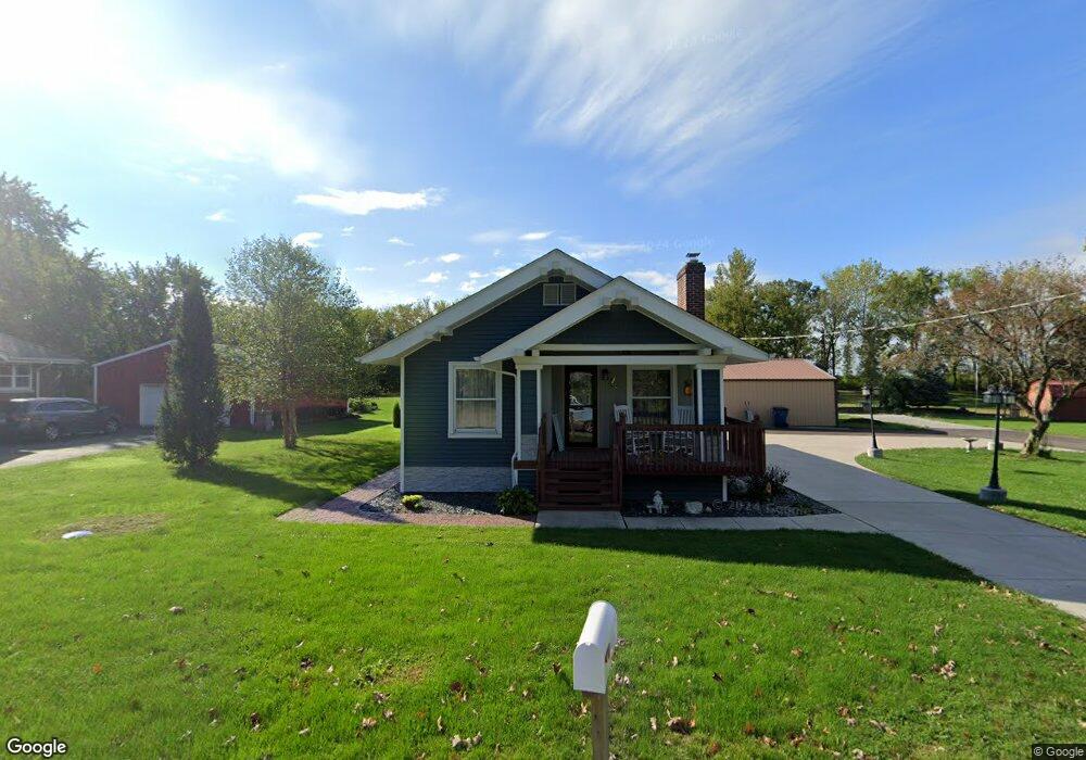
4805 E 117th Ave Crown Point, IN 46307
Estimated Value: $289,000 - $377,000
2
Beds
2
Baths
2,098
Sq Ft
$157/Sq Ft
Est. Value
About This Home
This home is located at 4805 E 117th Ave, Crown Point, IN 46307 and is currently estimated at $329,795, approximately $157 per square foot. 4805 E 117th Ave is a home located in Lake County with nearby schools including Winfield Elementary School, Colonel John Wheeler Middle School, and Crown Point High School.
Ownership History
Date
Name
Owned For
Owner Type
Purchase Details
Closed on
Mar 6, 2026
Sold by
Jarvis and Jarvis Ramona
Bought by
Jarvis William and Jarvis Ramona A
Current Estimated Value
Purchase Details
Closed on
Jul 17, 2025
Sold by
Baker Gregory L and Cunningham Wendy
Bought by
Jarvis William and Jarvis Ramona
Purchase Details
Closed on
Aug 29, 2008
Sold by
Allen James and Allen Carol Sue
Bought by
Baker Gregory L and Cunningham Wendy
Home Financials for this Owner
Home Financials are based on the most recent Mortgage that was taken out on this home.
Original Mortgage
$143,200
Interest Rate
6.66%
Mortgage Type
Purchase Money Mortgage
Create a Home Valuation Report for This Property
The Home Valuation Report is an in-depth analysis detailing your home's value as well as a comparison with similar homes in the area
Home Values in the Area
Average Home Value in this Area
Purchase History
| Date | Buyer | Sale Price | Title Company |
|---|---|---|---|
| Jarvis William | -- | Fidelity National Title | |
| Baker Gregory L | -- | Ticor Cp |
Source: Public Records
Mortgage History
| Date | Status | Borrower | Loan Amount |
|---|---|---|---|
| Previous Owner | Baker Gregory L | $143,200 |
Source: Public Records
Tax History
| Year | Tax Paid | Tax Assessment Tax Assessment Total Assessment is a certain percentage of the fair market value that is determined by local assessors to be the total taxable value of land and additions on the property. | Land | Improvement |
|---|---|---|---|---|
| 2025 | $3,371 | $291,600 | $88,800 | $202,800 |
| 2024 | $3,371 | $282,000 | $88,800 | $193,200 |
| 2023 | $3,326 | $259,700 | $88,800 | $170,900 |
| 2022 | $3,007 | $231,200 | $57,400 | $173,800 |
| 2021 | $2,301 | $193,600 | $53,700 | $139,900 |
| 2020 | $1,995 | $174,700 | $41,300 | $133,400 |
| 2019 | $1,961 | $173,800 | $37,300 | $136,500 |
| 2018 | $2,024 | $169,600 | $37,200 | $132,400 |
| 2017 | $2,009 | $167,800 | $37,200 | $130,600 |
| 2016 | $2,156 | $171,500 | $39,200 | $132,300 |
| 2014 | $1,356 | $139,400 | $39,200 | $100,200 |
| 2013 | $1,461 | $143,100 | $39,200 | $103,900 |
Source: Public Records
Map
Nearby Homes
- 4512 E 117th Ave
- 11664 Thomas St
- 11649 Thomas St
- 7522 E 116th Ave
- 7502 E 116th Ave
- 7482 E 116th Ave
- 6042 E 116th Ave
- 11090 Green Place
- 10929 Green Place
- 11136 Green Place
- 11474 Iris Place
- 10971 Elkhart Place
- 11144 Green Place
- 5970 E 112th Place
- 5984 E 112th Place
- 11084 Green Place
- 11066 Green Place
- 5716 E 110th Ave
- 11034 Green Place
- 5724 E 110th Ave
- 4809 E 117th Ave
- 4813 E 117th Ave
- 4712 E 117th Ave
- 4612 E 117th Ave
- 4817 E 117th Ave
- 11800 Decatur St
- 11736 Decatur St
- 11671 Benton St
- 11719 Decatur St
- 11814 Decatur St
- 11841 Decatur St
- 11916 Decatur St
- 5233 E 117th Ave
- 11426 Benton St
- 4212 E 117th Ave
- 11416 Benton St
- 11585 Benton St
- 11901 Decatur St
- 5452 E 117th Ave
- 4050 E 117th Ave
Your Personal Tour Guide
Ask me questions while you tour the home.