Estimated Value: $1,251,643 - $1,591,000
5
Beds
5
Baths
4,998
Sq Ft
$279/Sq Ft
Est. Value
About This Home
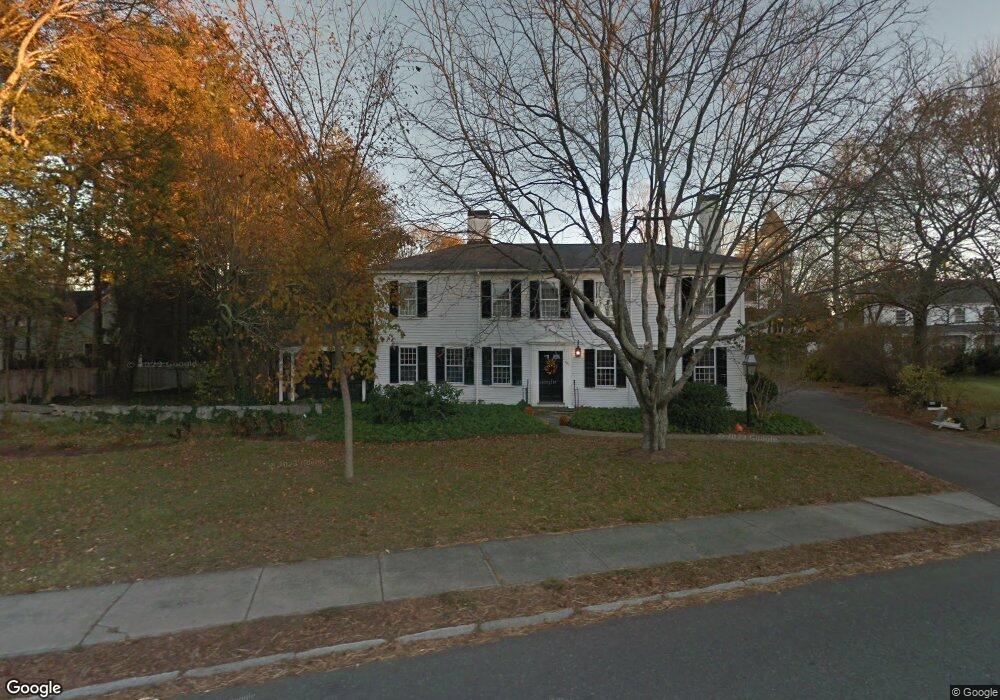
This home is located at 481 Main St, Acton, MA 01720 and is currently estimated at $1,394,661, approximately $279 per square foot. 481 Main St is a home located in Middlesex County with nearby schools including Acton-Boxborough Regional High School and Oak Meadow Montessori School.
Ownership History
Date
Name
Owned For
Owner Type
Purchase Details
Closed on
Jan 16, 2015
Sold by
Nyberg Barbara M
Bought by
B M Nyberg T 1
Current Estimated Value
Purchase Details
Closed on
Jan 30, 2009
Sold by
Nyberg David W
Bought by
Nyberg Barbara M
Home Financials for this Owner
Home Financials are based on the most recent Mortgage that was taken out on this home.
Original Mortgage
$300,000
Interest Rate
5.28%
Mortgage Type
Purchase Money Mortgage
Purchase Details
Closed on
Sep 16, 2005
Sold by
Acton Cong Chrch
Bought by
Nyberg David W
Home Financials for this Owner
Home Financials are based on the most recent Mortgage that was taken out on this home.
Original Mortgage
$359,650
Interest Rate
5.84%
Mortgage Type
Purchase Money Mortgage
Create a Home Valuation Report for This Property
The Home Valuation Report is an in-depth analysis detailing your home's value as well as a comparison with similar homes in the area
Home Values in the Area
Average Home Value in this Area
Purchase History
| Date | Buyer | Sale Price | Title Company |
|---|---|---|---|
| B M Nyberg T 1 | -- | -- | |
| Nyberg Barbara M | $400,000 | -- | |
| Nyberg David W | -- | -- | |
| Nyberg David W | $595,000 | -- |
Source: Public Records
Mortgage History
| Date | Status | Borrower | Loan Amount |
|---|---|---|---|
| Previous Owner | Nyberg Barbara M | $300,000 | |
| Previous Owner | Nyberg David W | $359,650 |
Source: Public Records
Tax History Compared to Growth
Tax History
| Year | Tax Paid | Tax Assessment Tax Assessment Total Assessment is a certain percentage of the fair market value that is determined by local assessors to be the total taxable value of land and additions on the property. | Land | Improvement |
|---|---|---|---|---|
| 2025 | $15,941 | $929,500 | $396,900 | $532,600 |
| 2024 | $15,495 | $929,500 | $396,900 | $532,600 |
| 2023 | $15,346 | $873,900 | $360,800 | $513,100 |
| 2022 | $14,786 | $760,200 | $313,700 | $446,500 |
| 2021 | $14,286 | $706,200 | $290,200 | $416,000 |
| 2020 | $13,747 | $714,500 | $290,200 | $424,300 |
| 2019 | $13,383 | $690,900 | $290,200 | $400,700 |
| 2018 | $13,217 | $682,000 | $290,200 | $391,800 |
| 2017 | $12,719 | $667,300 | $290,200 | $377,100 |
| 2016 | $12,717 | $661,300 | $290,200 | $371,100 |
| 2015 | $11,535 | $605,500 | $290,200 | $315,300 |
| 2014 | $11,285 | $580,200 | $290,200 | $290,000 |
Source: Public Records
Map
Nearby Homes
- 491 Main St
- 33 Meadowbrook Rd
- 709 Main St
- 11 Braebrook
- 524 Main St
- 46 Taylor Rd
- 187 Great Rd Unit A1
- 1 Bayberry Rd
- 246 Main St Unit 2
- 7 Kelley Rd
- 134 Pope Rd
- 159 Skyline Dr Unit 159
- 388 Great Rd Unit B14
- 386 Great Rd Unit A8
- 390 Great Rd Unit B16
- 70 River St
- 60 Lawsbrook Rd
- 104 Channing Rd
- 4 Huron Rd
- 129 Main St Unit 129
- 8 Concord Rd
- LotA-b Ledgerock Way
- lot5 Constitution Dr
- 12 Homeowner St
- 487 Main St
- B-3 Concord Rd
- 468 Main St
- 3 Wood Ln
- 20 Concord Rd Unit 1
- 20 Concord Rd
- 3 Newtown Rd
- 492 Main St Unit B
- 494 Main St
- 494 Main St Unit 494A
- 492 Main St
- 461 Main St
- 10 Wood Ln
- 46 Nagog Hill Rd
- 48 Nagog Hill Rd
- 12 Woodbury Ln