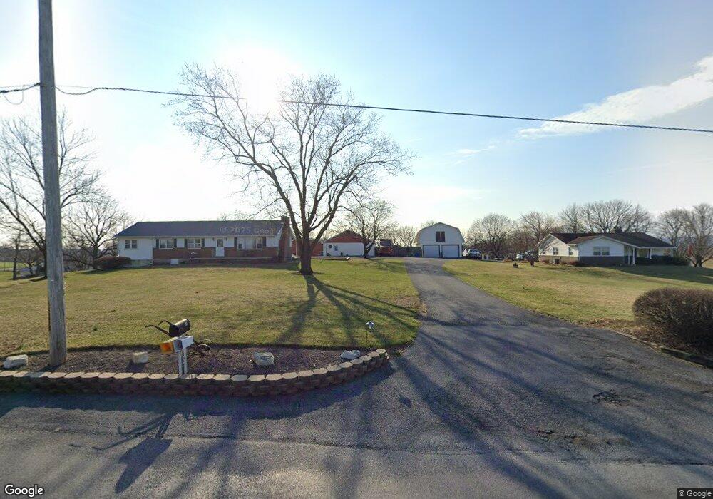
481 Manbeck Rd Robesonia, PA 19551
North Heidelberg NeighborhoodEstimated Value: $229,000 - $386,047
3
Beds
2
Baths
1,680
Sq Ft
$203/Sq Ft
Est. Value
About This Home
This home is located at 481 Manbeck Rd, Robesonia, PA 19551 and is currently estimated at $341,762, approximately $203 per square foot. 481 Manbeck Rd is a home located in Berks County with nearby schools including Conrad Weiser High School and River Rock Academy.
Ownership History
Date
Name
Owned For
Owner Type
Purchase Details
Closed on
Dec 13, 2019
Sold by
Benzel Terry L
Bought by
Benzel Codi D
Current Estimated Value
Home Financials for this Owner
Home Financials are based on the most recent Mortgage that was taken out on this home.
Original Mortgage
$85,000
Outstanding Balance
$66,604
Interest Rate
3.7%
Mortgage Type
New Conventional
Estimated Equity
$275,158
Purchase Details
Closed on
Jan 16, 2014
Sold by
Benzel Lillian M and Moll Geraldine
Bought by
Benzel Terry
Purchase Details
Closed on
Nov 21, 1973
Bought by
Benzel Lillian M
Create a Home Valuation Report for This Property
The Home Valuation Report is an in-depth analysis detailing your home's value as well as a comparison with similar homes in the area
Home Values in the Area
Average Home Value in this Area
Purchase History
| Date | Buyer | Sale Price | Title Company |
|---|---|---|---|
| Benzel Codi D | $108,000 | None Available | |
| Benzel Terry | -- | None Available | |
| Benzel Lillian M | -- | -- |
Source: Public Records
Mortgage History
| Date | Status | Borrower | Loan Amount |
|---|---|---|---|
| Open | Benzel Codi D | $85,000 |
Source: Public Records
Tax History Compared to Growth
Tax History
| Year | Tax Paid | Tax Assessment Tax Assessment Total Assessment is a certain percentage of the fair market value that is determined by local assessors to be the total taxable value of land and additions on the property. | Land | Improvement |
|---|---|---|---|---|
| 2025 | $1,277 | $127,500 | $43,800 | $83,700 |
| 2024 | $5,381 | $127,500 | $43,800 | $83,700 |
| 2023 | $5,230 | $127,500 | $43,800 | $83,700 |
| 2022 | $5,105 | $127,500 | $43,800 | $83,700 |
| 2021 | $5,009 | $127,500 | $43,800 | $83,700 |
| 2020 | $4,884 | $127,500 | $43,800 | $83,700 |
| 2019 | $4,783 | $127,500 | $43,800 | $83,700 |
| 2018 | $4,674 | $127,500 | $43,800 | $83,700 |
| 2017 | $4,527 | $127,500 | $43,800 | $83,700 |
| 2016 | $1,046 | $127,500 | $43,800 | $83,700 |
| 2015 | $1,046 | $127,500 | $43,800 | $83,700 |
| 2014 | $1,046 | $127,500 | $43,800 | $83,700 |
Source: Public Records
Map
Nearby Homes
- 356 Big Spring Rd
- 305 Martha St
- 311 Fry Ave
- 1144 Brownsville Rd
- 201 N Linden St
- 119 N Robeson St
- 19 W Penn Ave
- 36 N Church St
- 102 W Ruth Ave
- 208 S Elm St
- 226 W Ruth Ave
- 402 Smokering Dr
- 260 Wooltown Rd
- 260 LOT 18 Wooltown Rd
- 0 Old Furnace Rd Unit PABK2060366
- 200 W Meadow Ave
- 707 W Penn Ave
- 33 Ginna b Dr
- 199 Point Rd
- 35 Sabrina St
- 473 Manbeck Rd
- 509 Manbeck Rd
- 1982 Brownsville Rd
- 465 Manbeck Rd
- 1974 Brownsville Rd
- 1977 Brownsville Rd
- 530 Manbeck Rd
- 1968 Brownsville Rd
- 1968 Brownsville Rd
- 461 Manbeck Rd
- 273 Brownsville Rd
- 457 Manbeck Rd
- 2106 Brownsville Rd
- 2087 Brownsville Rd
- 1950 Brownsville Rd
- 2095 Brownsville Rd
- 603 Manbeck Rd
- 1920 Brownsville Rd
- 272 Stricker Rd
- 610 Manbeck Rd