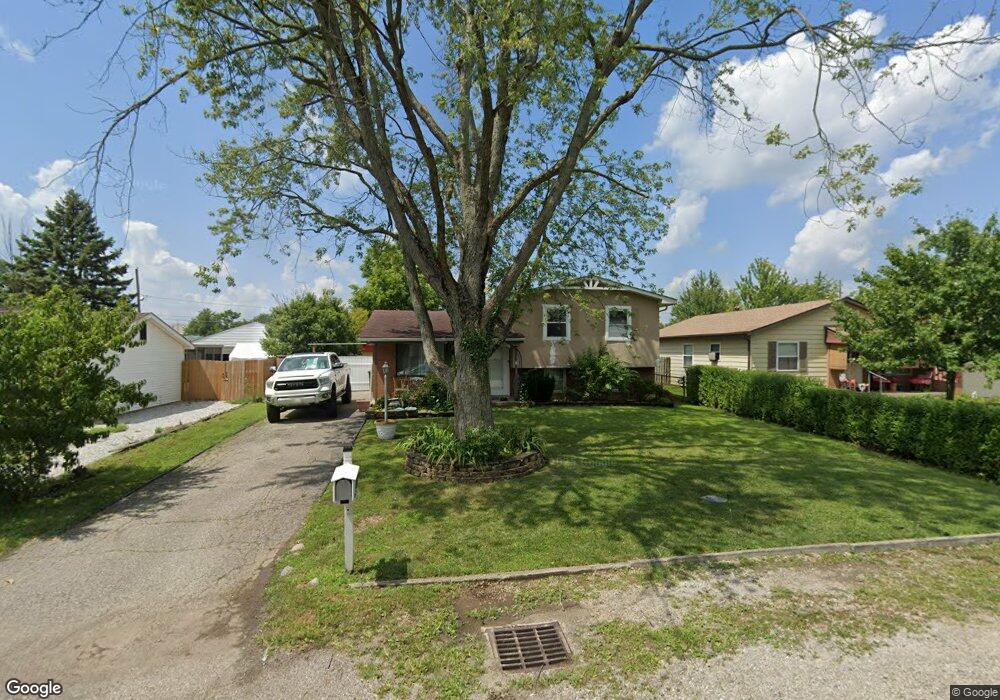
481 Smith Rd Columbus, OH 43228
Estimated Value: $225,707 - $246,000
3
Beds
1
Bath
1,314
Sq Ft
$178/Sq Ft
Est. Value
About This Home
This home is located at 481 Smith Rd, Columbus, OH 43228 and is currently estimated at $233,427, approximately $177 per square foot. 481 Smith Rd is a home located in Franklin County with nearby schools including Galloway Ridge Intermediate School, Prairie Lincoln Elementary School, and Norton Middle School.
Ownership History
Date
Name
Owned For
Owner Type
Purchase Details
Closed on
Jan 25, 2011
Sold by
Cunningham Daniel and Cunningham Kimberly
Bought by
American General Financial Services Inc
Current Estimated Value
Purchase Details
Closed on
Aug 5, 2003
Sold by
Ball Charles D and Ball Annie
Bought by
Cunningham Daniel and Cunningham Kimberly
Home Financials for this Owner
Home Financials are based on the most recent Mortgage that was taken out on this home.
Original Mortgage
$102,464
Interest Rate
5.62%
Mortgage Type
FHA
Purchase Details
Closed on
Feb 19, 1999
Sold by
Hummel Robert O and Hummel Shirley J
Bought by
Ball Charles D
Home Financials for this Owner
Home Financials are based on the most recent Mortgage that was taken out on this home.
Original Mortgage
$89,954
Interest Rate
6.88%
Mortgage Type
FHA
Purchase Details
Closed on
Sep 2, 1975
Bought by
Hummel Robert O
Create a Home Valuation Report for This Property
The Home Valuation Report is an in-depth analysis detailing your home's value as well as a comparison with similar homes in the area
Home Values in the Area
Average Home Value in this Area
Purchase History
| Date | Buyer | Sale Price | Title Company |
|---|---|---|---|
| American General Financial Services Inc | $56,000 | None Available | |
| Cunningham Daniel | $103,800 | -- | |
| Ball Charles D | $90,000 | Franklin Abstract | |
| Hummel Robert O | -- | -- |
Source: Public Records
Mortgage History
| Date | Status | Borrower | Loan Amount |
|---|---|---|---|
| Previous Owner | Cunningham Daniel | $102,464 | |
| Previous Owner | Ball Charles D | $89,954 |
Source: Public Records
Tax History
| Year | Tax Paid | Tax Assessment Tax Assessment Total Assessment is a certain percentage of the fair market value that is determined by local assessors to be the total taxable value of land and additions on the property. | Land | Improvement |
|---|---|---|---|---|
| 2025 | $2,726 | $60,590 | $15,960 | $44,630 |
| 2024 | $2,726 | $60,590 | $15,960 | $44,630 |
| 2023 | $2,601 | $60,585 | $15,960 | $44,625 |
| 2022 | $1,399 | $22,900 | $4,100 | $18,800 |
| 2021 | $1,422 | $22,900 | $4,100 | $18,800 |
| 2020 | $1,416 | $22,900 | $4,100 | $18,800 |
| 2019 | $1,350 | $19,080 | $3,400 | $15,680 |
| 2018 | $1,529 | $19,080 | $3,400 | $15,680 |
| 2017 | $1,273 | $19,080 | $3,400 | $15,680 |
| 2016 | $1,711 | $23,420 | $6,090 | $17,330 |
| 2015 | $1,711 | $23,420 | $6,090 | $17,330 |
| 2014 | $1,712 | $23,420 | $6,090 | $17,330 |
| 2013 | $997 | $27,545 | $7,175 | $20,370 |
Source: Public Records
Map
Nearby Homes
- 381 Pasadena Ave
- 5648 Larksdale Dr
- 5409 Longworth Dr
- 5713 Larksdale Dr
- 5412 Cedar Springs Unit 5412A
- 376 Galloway Ridge Dr
- 5488 Cypress Chase Unit 5488
- 69 Lawrence Ave
- 5765 Westbank Dr
- 5773 Westbank Dr
- 5536 Cedar Springs Unit 5536A
- 952 Hartford Village Blvd Unit 952
- 5621 Cedar Springs Unit 5621
- 988 Hartford Village Blvd Unit 988
- 1054 Shady Lake Dr Unit 1054
- 998 Hartford Village Blvd Unit 998
- 1010 Hartford Village Blvd Unit 1010
- 1024 Hartford Village Blvd Unit 1024
- 824 Cape Henry Dr
- 5879 Katara Dr
Your Personal Tour Guide
Ask me questions while you tour the home.