
Seller's Agent in 2025
Earle Kenney
Sprague & Curtis Real Estate
(207) 395-4695
286 Total Sales


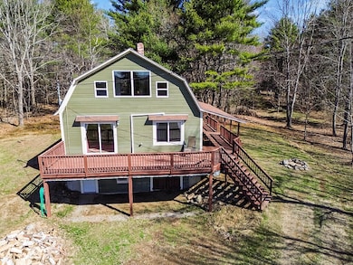
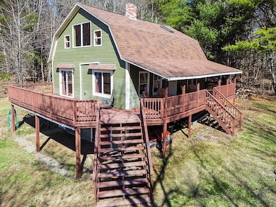
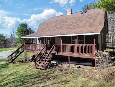
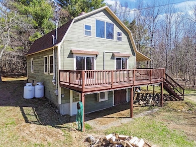
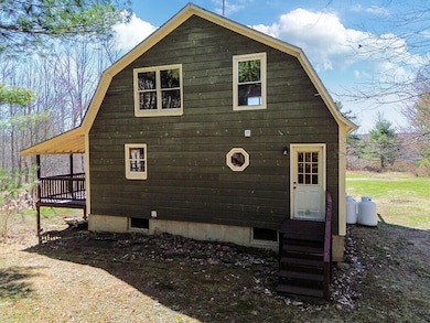
Here's a very nice Gambrel style home with lots of acreage! Located in Unity, an easy commute to Waterville, Augusta or Belfast areas. This home features an open dine-in kitchen with stove and refrigerator, large living room with woodstove and lots of south facing glass. Second floor features 2 bedrooms plus a loft that can be used as a bedroom or den. Full basement is great for storage and has walkout access to the yard. Huge deck on 2 sides is great for a party or grilling area - one section is covered. Several ways to heat - wood, propane and heat pumps. Heat pumps are also great for summer cooling. Plenty of space for a garden if you desire. Wooded acreage complete with wildlife! Just down the road is the Common Ground Fairgrounds which celebrates rural living with MOFGA. The beloved Lost Kitchen is just a mile away.
Last Agent to Sell the Property
Sprague & Curtis Real Estate Brokerage Email: earle@spragueandcurtis.com Listed on: 07/01/2025
| Date | Type | Sale Price | Title Company |
|---|---|---|---|
| Personal Reps Deed | $330,000 | -- | |
| Personal Reps Deed | $330,000 | -- | |
| Interfamily Deed Transfer | -- | -- | |
| Interfamily Deed Transfer | -- | -- | |
| Warranty Deed | -- | -- | |
| Warranty Deed | -- | -- | |
| Warranty Deed | -- | -- |
| Date | Status | Loan Amount | Loan Type |
|---|---|---|---|
| Open | $264,000 | Credit Line Revolving | |
| Closed | $264,000 | New Conventional | |
| Previous Owner | $118,400 | New Conventional | |
| Previous Owner | $86,734 | Commercial |
| Date | Event | Price | List to Sale | Price per Sq Ft |
|---|---|---|---|---|
| 08/12/2025 08/12/25 | Sold | $330,000 | 0.0% | $246 / Sq Ft |
| 07/15/2025 07/15/25 | Pending | -- | -- | -- |
| 07/01/2025 07/01/25 | Price Changed | $330,000 | 0.0% | $246 / Sq Ft |
| 07/01/2025 07/01/25 | For Sale | $330,000 | 0.0% | $246 / Sq Ft |
| 05/08/2025 05/08/25 | Off Market | $330,000 | -- | -- |
| 04/25/2025 04/25/25 | For Sale | $375,000 | -- | $279 / Sq Ft |
| Year | Tax Paid | Tax Assessment Tax Assessment Total Assessment is a certain percentage of the fair market value that is determined by local assessors to be the total taxable value of land and additions on the property. | Land | Improvement |
|---|---|---|---|---|
| 2024 | $2,589 | $170,900 | $57,500 | $113,400 |
| 2022 | $2,174 | $136,700 | $46,000 | $90,700 |
| 2021 | $2,208 | $136,700 | $46,000 | $90,700 |
| 2020 | $2,385 | $136,700 | $46,000 | $90,700 |
| 2019 | $2,385 | $136,700 | $46,000 | $90,700 |
| 2018 | $2,290 | $136,700 | $46,000 | $90,700 |
| 2017 | $2,276 | $136,700 | $46,000 | $90,700 |
| 2016 | $2,303 | $136,700 | $46,000 | $90,700 |
| 2014 | $2,023 | $136,700 | $46,000 | $90,700 |
| 2013 | $1,832 | $136,700 | $46,000 | $90,700 |
Seller's Agent in 2025
Earle Kenney
Sprague & Curtis Real Estate
(207) 395-4695
286 Total Sales
A
Buyer's Agent in 2025
Aaren James
Fontaine Family-The Real Estate Leader
(207) 699-7022
30 Total Sales
Source: Maine Listings
MLS Number: 1620271
APN: UNIW-000003-000000-000022
Disclaimer: Certain information contained herein is derived from information provided by parties other than Homes.com. All information provided is deemed reliable, but is not guaranteed to be accurate and should be independently verified.
![]() Listing data is derived in whole or in part from Maine Real Estate Information System, Inc. (d/b/a Maine Listings) and is for consumers' personal, noncommercial use only. Dimensions are approximate and not guaranteed. All data should be independently verified.
Listing data is derived in whole or in part from Maine Real Estate Information System, Inc. (d/b/a Maine Listings) and is for consumers' personal, noncommercial use only. Dimensions are approximate and not guaranteed. All data should be independently verified.
© 2026 Maine Real Estate Information System, Inc. All Rights Reserved. Equal Housing Opportunity.
Homes.com, LLC, 17600 Laguna Canyon Rd Irvine, CA 92618 (888)-952-6393
![]()
Ask me questions while you tour the home.