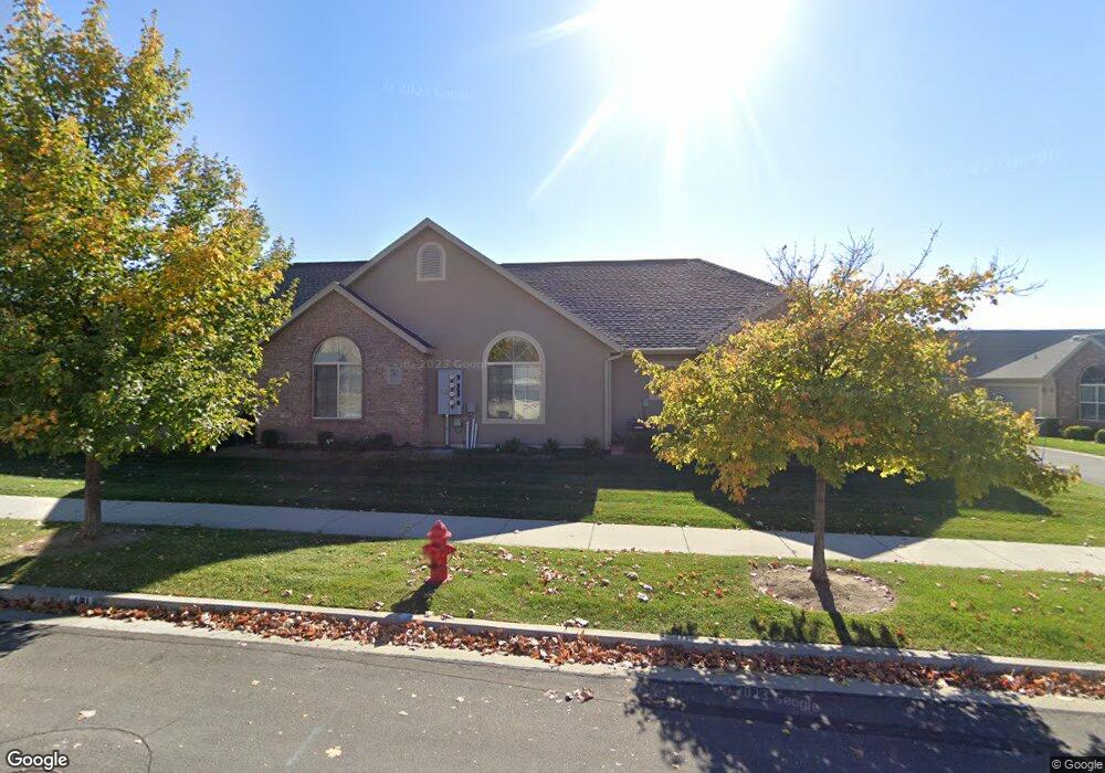
481 W 350 S Unit B Springville, UT 84663
Westfields North NeighborhoodEstimated Value: $480,000 - $516,085
2
Beds
2
Baths
1,864
Sq Ft
$263/Sq Ft
Est. Value
About This Home
This home is located at 481 W 350 S Unit B, Springville, UT 84663 and is currently estimated at $490,521, approximately $263 per square foot. 481 W 350 S Unit B is a home located in Utah County with nearby schools including Westside Elementary School, Springville Junior High School, and Springville High School.
Ownership History
Date
Name
Owned For
Owner Type
Purchase Details
Closed on
Aug 4, 2022
Sold by
Heath Family Trust
Bought by
Willis Family Trust
Current Estimated Value
Purchase Details
Closed on
Sep 25, 2014
Sold by
Gilland Andrew and Gilland Carolyn
Bought by
Andrew And Carolyn Gilland Living Trust
Purchase Details
Closed on
Sep 27, 2013
Sold by
Leisure Villas Inc
Bought by
Gilland Andrew and Gilland Carolyn
Create a Home Valuation Report for This Property
The Home Valuation Report is an in-depth analysis detailing your home's value as well as a comparison with similar homes in the area
Home Values in the Area
Average Home Value in this Area
Purchase History
| Date | Buyer | Sale Price | Title Company |
|---|---|---|---|
| Willis Family Trust | -- | Gt Title Services | |
| Andrew And Carolyn Gilland Living Trust | -- | None Available | |
| Gilland Andrew | -- | Pro Title And Escrow Inc |
Source: Public Records
Tax History Compared to Growth
Tax History
| Year | Tax Paid | Tax Assessment Tax Assessment Total Assessment is a certain percentage of the fair market value that is determined by local assessors to be the total taxable value of land and additions on the property. | Land | Improvement |
|---|---|---|---|---|
| 2025 | $2,535 | $478,700 | $53,200 | $425,500 |
| 2024 | $2,535 | $251,625 | $0 | $0 |
| 2023 | $2,619 | $262,405 | $0 | $0 |
| 2022 | $2,762 | $271,755 | $0 | $0 |
| 2021 | $2,375 | $363,300 | $43,600 | $319,700 |
| 2020 | $2,311 | $342,700 | $41,100 | $301,600 |
| 2019 | $2,076 | $313,000 | $34,700 | $278,300 |
| 2018 | $1,979 | $284,500 | $34,700 | $249,800 |
| 2017 | $1,969 | $150,150 | $0 | $0 |
| 2016 | $1,935 | $144,650 | $0 | $0 |
| 2015 | $1,740 | $132,550 | $0 | $0 |
| 2014 | $1,712 | $129,250 | $0 | $0 |
Source: Public Records
Map
Nearby Homes
- 293 S 450 W Unit B
- 550 S 400 W
- 532 W 300 S Unit B
- 224 S 550 W Unit B-2
- 1768 W 300 S Unit D
- 12 N 450 W
- 311 W Center St
- 618 S 100 W Unit 302
- 745 S Harrison Dr W Unit 37
- 743 S Harrison Dr W Unit 36
- 729 S Harrison Dr
- 721 S Harrison Dr Unit 30
- 717 S Harrison Dr Unit 29
- 742 S Harrison Dr Unit 13
- 776 S Harrison Dr Unit 78
- 785 S Harrison Dr Unit 51
- 749 S Harrison Dr Unit 38
- 751 S Harrison Dr Unit 28
- 64 W 600 S Unit C205
- 675 S 100 W Unit A305
- 487 W 350 S Unit C
- 487 W 350 S Unit B
- 473 W 350 S Unit D
- 473 W 350 S Unit C
- 473 W 350 S Unit B
- 484 W 350 S Unit A
- 484 W 350 S Unit D
- 484 W 350 S Unit 118
- 496 W 350 S Unit B
- 472 W 350 S Unit A
- 472 W 350 S Unit B
- 472 W 350 S Unit C
- 489 W 300 S Unit 11D
- 489 W 300 S Unit 10C
- 489 W 300 S
- 489 W 300 S
- 489 W 300 S Unit B
- 477 W 300 S
- 477 W 300 S
- 477 W 300 S Unit 5B