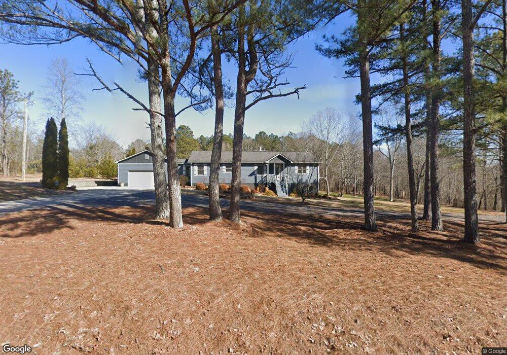
481 Woodrow Kay Rd Rockmart, GA 30153
Estimated Value: $296,000 - $344,000
3
Beds
2
Baths
1,680
Sq Ft
$190/Sq Ft
Est. Value
About This Home
This home is located at 481 Woodrow Kay Rd, Rockmart, GA 30153 and is currently estimated at $319,069, approximately $189 per square foot. 481 Woodrow Kay Rd is a home located in Paulding County with nearby schools including Sara M. Ragsdale Elementary School, Carl Scoggins Sr. Middle School, and Paulding County High School.
Ownership History
Date
Name
Owned For
Owner Type
Purchase Details
Closed on
Jun 3, 1999
Sold by
Brazier James
Bought by
Brazier James O
Current Estimated Value
Home Financials for this Owner
Home Financials are based on the most recent Mortgage that was taken out on this home.
Original Mortgage
$69,600
Outstanding Balance
$18,129
Interest Rate
6.9%
Mortgage Type
New Conventional
Estimated Equity
$300,940
Create a Home Valuation Report for This Property
The Home Valuation Report is an in-depth analysis detailing your home's value as well as a comparison with similar homes in the area
Home Values in the Area
Average Home Value in this Area
Purchase History
| Date | Buyer | Sale Price | Title Company |
|---|---|---|---|
| Brazier James O | -- | -- |
Source: Public Records
Mortgage History
| Date | Status | Borrower | Loan Amount |
|---|---|---|---|
| Open | Brazier James O | $69,600 |
Source: Public Records
Tax History Compared to Growth
Tax History
| Year | Tax Paid | Tax Assessment Tax Assessment Total Assessment is a certain percentage of the fair market value that is determined by local assessors to be the total taxable value of land and additions on the property. | Land | Improvement |
|---|---|---|---|---|
| 2024 | $1,763 | $119,268 | $15,680 | $103,588 |
| 2023 | $1,989 | $123,760 | $13,960 | $109,800 |
| 2022 | $2,415 | $94,524 | $12,520 | $82,004 |
| 2021 | $2,160 | $76,208 | $10,000 | $66,208 |
| 2020 | $2,056 | $71,092 | $10,520 | $60,572 |
| 2019 | $1,915 | $65,424 | $9,080 | $56,344 |
| 2018 | $1,836 | $60,940 | $8,680 | $52,260 |
| 2016 | $1,398 | $48,108 | $9,360 | $38,748 |
| 2015 | $1,331 | $45,092 | $9,360 | $35,732 |
| 2014 | $1,205 | $40,028 | $8,040 | $31,988 |
| 2013 | -- | $30,880 | $8,040 | $22,840 |
Source: Public Records
Map
Nearby Homes
- 79 Southern Trace Dr
- 96 Southern Trace Dr
- 69 Southern Trace Way
- 440 Prometheous Way
- 96 Southern Trace Way
- 256 Prometheous Way
- 412 Southern Trace Dr
- 572 Southern Trace Dr
- 117 Wallace Way
- 280 Carthage Blvd
- 318 Thorn Thicket Dr
- 110 Conifer Ln
- 169 Winding Valley Dr
- 61 Fairfax Dr
- 53 Adams Ln
- 39 Rosemary Path
- 174 Randall Dr
- 3639 Holly Springs Rd
- 494 Woodrow Kay Rd
- 18 Southern Trace Dr
- 44 Southern Trace Dr
- 933 Brown Rd
- 568 Woodrow Kay Rd
- 415 Woodrow Kay Rd
- 70 Southern Trace Dr
- 70 Southern Trace Dr Unit 1007
- 484 Woodrow Kay Rd
- 903 Brown Rd
- 86 Southern Trace Dr
- 125 Southern Trace Dr
- 404 Woodrow Kay Rd
- 120 Southern Trace Dr
- 609 Woodrow Kay Rd
- 0 Brown Rd
- 0 Brown Rd Unit 7265976
- 0 Brown Rd Unit 7064400
- 0 Brown Rd Unit 8718035
- 0 Brown Rd Unit 8647384