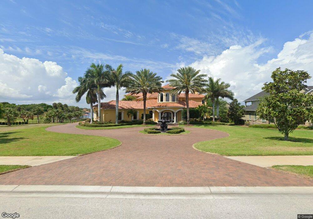
4810 Honeyridge Ln Merritt Island, FL 32952
Estimated Value: $1,786,000 - $3,051,000
6
Beds
6
Baths
6,245
Sq Ft
$400/Sq Ft
Est. Value
About This Home
This home is located at 4810 Honeyridge Ln, Merritt Island, FL 32952 and is currently estimated at $2,496,393, approximately $399 per square foot. 4810 Honeyridge Ln is a home located in Brevard County with nearby schools including Tropical Elementary School, Thomas Jefferson Middle School, and Merritt Island High School.
Ownership History
Date
Name
Owned For
Owner Type
Purchase Details
Closed on
Mar 15, 2018
Sold by
Eichin Mark A and Eichin Donna L
Bought by
Eician Mark A and Eichin Donna L
Current Estimated Value
Purchase Details
Closed on
Oct 23, 2002
Sold by
Bluffs Dev Corp
Bought by
Luthra Venu K and Luthra Ashma K
Home Financials for this Owner
Home Financials are based on the most recent Mortgage that was taken out on this home.
Original Mortgage
$254,026
Interest Rate
6.01%
Create a Home Valuation Report for This Property
The Home Valuation Report is an in-depth analysis detailing your home's value as well as a comparison with similar homes in the area
Home Values in the Area
Average Home Value in this Area
Purchase History
| Date | Buyer | Sale Price | Title Company |
|---|---|---|---|
| Eician Mark A | -- | Attorney | |
| Luthra Venu K | $275,000 | -- |
Source: Public Records
Mortgage History
| Date | Status | Borrower | Loan Amount |
|---|---|---|---|
| Previous Owner | Luthra Venu K | $254,026 |
Source: Public Records
Tax History Compared to Growth
Tax History
| Year | Tax Paid | Tax Assessment Tax Assessment Total Assessment is a certain percentage of the fair market value that is determined by local assessors to be the total taxable value of land and additions on the property. | Land | Improvement |
|---|---|---|---|---|
| 2025 | $13,154 | $1,109,700 | -- | -- |
| 2024 | $13,114 | $1,078,430 | -- | -- |
| 2023 | $13,114 | $1,047,020 | $0 | $0 |
| 2022 | $12,281 | $1,016,530 | $0 | $0 |
| 2021 | $13,055 | $986,930 | $0 | $0 |
| 2020 | $13,103 | $973,310 | $0 | $0 |
| 2019 | $13,149 | $951,430 | $0 | $0 |
| 2018 | $13,256 | $933,690 | $0 | $0 |
| 2017 | $13,516 | $914,490 | $0 | $0 |
| 2016 | $13,848 | $895,690 | $450,470 | $445,220 |
| 2015 | $14,365 | $889,470 | $400,470 | $489,000 |
| 2014 | $14,506 | $882,420 | $400,470 | $481,950 |
Source: Public Records
Map
Nearby Homes
- 4760 Honeyridge Ln
- 5140 Del Sol Dr
- 5160 Del Sol Dr
- 190 Stewart Dr
- 5180 Calmes Way
- 155 Hacienda Dr
- 4395 Crooked Mile Rd
- 735 Pilot Ln Unit 314
- 735 Pilot Ln Unit 812
- 735 Pilot Ln Unit 408
- 735 Pilot Ln Unit 603
- 735 Pilot Ln Unit 614
- 735 Pilot Ln Unit 611
- 735 Pilot Ln Unit 908
- 735 Pilot Ln Unit 606
- 735 Pilot Ln Unit 1004
- 735 Pilot Ln Unit 510
- 735 Pilot Ln Unit 814
- 4320 Crooked Mile Rd
- 4245 Hillview Cir
- 4800 Honeyridge Ln
- 4790 Honeyridge Ln
- 4821 Honeyridge Ln
- 4801 Honeyridge Ln
- 4811 Honeyridge Ln
- 4840 Honeyridge Ln
- 4780 Honeyridge Ln
- 4850 Honeyridge Ln
- 4791 Honeyridge Ln
- 4870 Belize Ln
- 4781 Honeyridge Ln
- 4770 Honeyridge Ln
- 4771 Honeyridge Ln
- 5021 Valle Collina Ln
- 5030 Valle Collina Ln
- 5031 Valle Collina Ln
- 5052 Del Sol Dr
- 0 Del Sol Dr
- 4761 Honeyridge Ln
- 4830 Honeyridge Ln