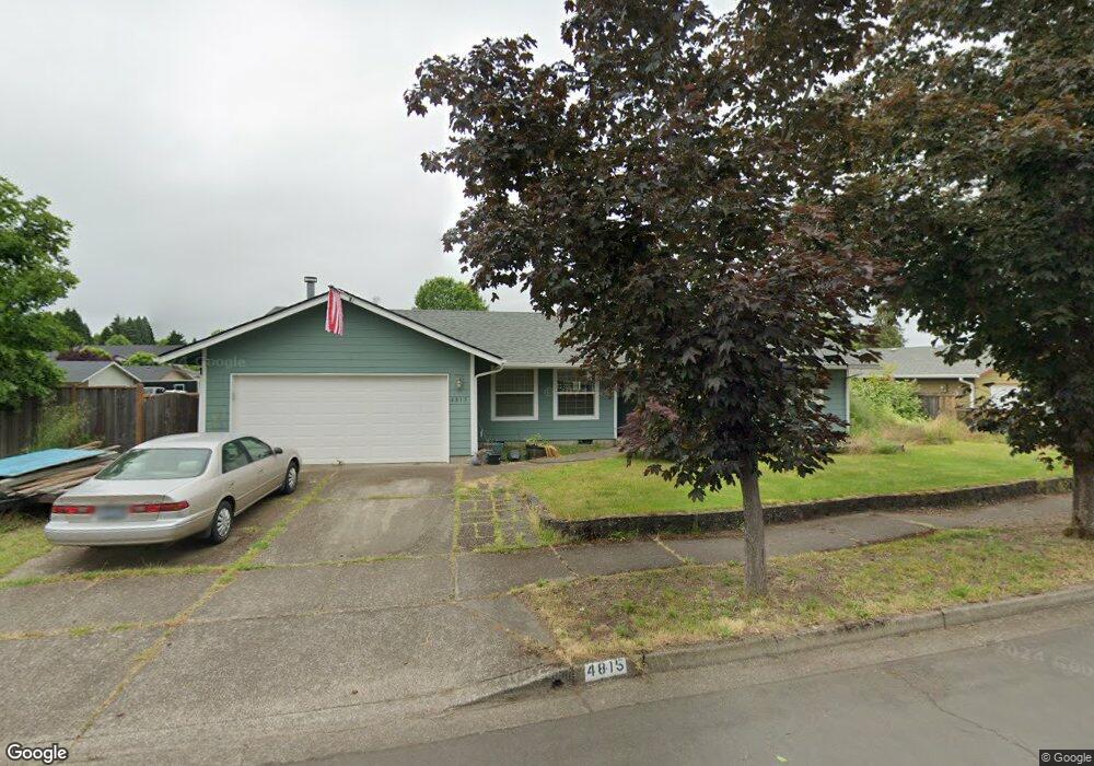
4815 Teralee Ln Eugene, OR 97402
Bethel NeighborhoodEstimated Value: $370,000 - $387,000
3
Beds
2
Baths
1,356
Sq Ft
$281/Sq Ft
Est. Value
About This Home
This home is located at 4815 Teralee Ln, Eugene, OR 97402 and is currently estimated at $381,395, approximately $281 per square foot. 4815 Teralee Ln is a home located in Lane County with nearby schools including Danebo Elementary School, Shasta Middle School, and Willamette High School.
Ownership History
Date
Name
Owned For
Owner Type
Purchase Details
Closed on
Jun 6, 2002
Sold by
Smith Harvey F and Smith Alice Joyce
Bought by
Backer John A and Backer Ruth E
Current Estimated Value
Home Financials for this Owner
Home Financials are based on the most recent Mortgage that was taken out on this home.
Original Mortgage
$118,830
Outstanding Balance
$49,331
Interest Rate
6.83%
Mortgage Type
VA
Estimated Equity
$332,064
Create a Home Valuation Report for This Property
The Home Valuation Report is an in-depth analysis detailing your home's value as well as a comparison with similar homes in the area
Home Values in the Area
Average Home Value in this Area
Purchase History
| Date | Buyer | Sale Price | Title Company |
|---|---|---|---|
| Backer John A | $116,500 | Fidelity National Title Ins |
Source: Public Records
Mortgage History
| Date | Status | Borrower | Loan Amount |
|---|---|---|---|
| Open | Backer John A | $118,830 |
Source: Public Records
Tax History
| Year | Tax Paid | Tax Assessment Tax Assessment Total Assessment is a certain percentage of the fair market value that is determined by local assessors to be the total taxable value of land and additions on the property. | Land | Improvement |
|---|---|---|---|---|
| 2025 | $3,253 | $218,558 | -- | -- |
| 2024 | $3,171 | $212,193 | -- | -- |
| 2023 | $3,171 | $206,013 | $0 | $0 |
| 2022 | $2,951 | $200,013 | $0 | $0 |
| 2021 | $2,889 | $194,188 | $0 | $0 |
| 2020 | $2,805 | $188,533 | $0 | $0 |
| 2019 | $2,667 | $183,042 | $0 | $0 |
| 2018 | $2,593 | $172,535 | $0 | $0 |
| 2017 | $2,478 | $172,535 | $0 | $0 |
| 2016 | $2,415 | $167,510 | $0 | $0 |
| 2015 | $2,766 | $162,631 | $0 | $0 |
| 2014 | $2,724 | $157,894 | $0 | $0 |
Source: Public Records
Map
Nearby Homes
- 4900 Royal Ave Unit 105
- 4900 Royal Ave Unit SP13
- 4985 Cone Ave
- 4749 Royal Ave
- 536 Raber Rd
- 4467 Fergus Ave
- 4462 Fergus Ave
- 5260 Forest Ln
- 654 Saint Charles St
- 647 Oakwood Dr
- 639 Oakwood Dr
- 648 Oakwood Dr
- 870 Laurelhurst Dr
- 671 Saint Charles St
- 683 Saint Charles St
- 5254 Forest Ln
- 658 Saint Charles St
- 664 Saint Charles St
- 715 St Charles St
- 670 Saint Charles St
- 4819 Teralee Ln
- 4807 Teralee Ln
- 4823 Teralee Ln
- 4871 Teralee Ln
- 4816 Teralee Ln
- 4803 Teralee Ln
- 4848 Teralee Ln
- 4810 Teralee Ln
- 4808 Teralee Ln
- 4866 Teralee Ln
- 4827 Teralee Ln
- 4806 Teralee Ln
- 4863 Teralee Ln
- 4876 Teralee Ln
- 4793 Teralee Ln
- 4795 Teralee Ln
- 4797 Teralee Ln
- 4802 Teralee Ln
- 4859 Teralee Ln
- 515 Roper Rd
Your Personal Tour Guide
Ask me questions while you tour the home.