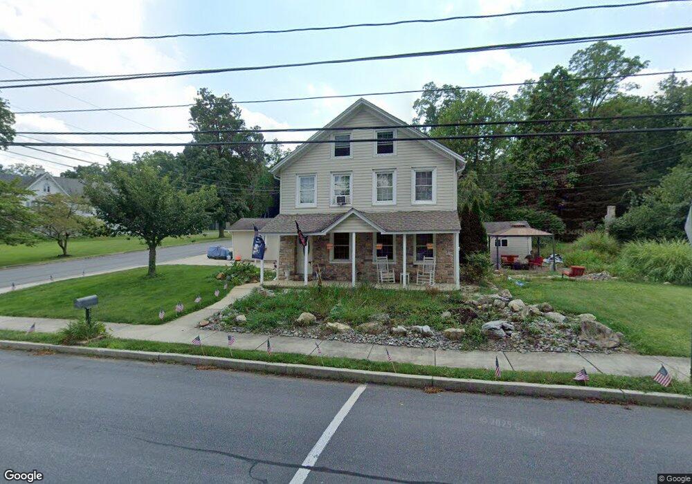
482 Franklin St Alburtis, PA 18011
Lower Macungie Township West NeighborhoodEstimated Value: $401,665 - $467,000
4
Beds
3
Baths
2,322
Sq Ft
$186/Sq Ft
Est. Value
About This Home
This home is located at 482 Franklin St, Alburtis, PA 18011 and is currently estimated at $430,916, approximately $185 per square foot. 482 Franklin St is a home located in Lehigh County with nearby schools including Alburtis Elementary School, Lower Macungie Middle School, and Emmaus High School.
Ownership History
Date
Name
Owned For
Owner Type
Purchase Details
Closed on
Dec 3, 2015
Sold by
Spiva Danielle D and Pahula Danielle D
Bought by
Spiva Danielle D
Current Estimated Value
Home Financials for this Owner
Home Financials are based on the most recent Mortgage that was taken out on this home.
Original Mortgage
$211,200
Outstanding Balance
$167,689
Interest Rate
3.99%
Mortgage Type
New Conventional
Estimated Equity
$263,228
Purchase Details
Closed on
Jul 28, 2006
Sold by
Goodman Daniel D and Goodman Richard M
Bought by
Pahula Danielle D
Home Financials for this Owner
Home Financials are based on the most recent Mortgage that was taken out on this home.
Original Mortgage
$242,100
Interest Rate
6.88%
Mortgage Type
Purchase Money Mortgage
Create a Home Valuation Report for This Property
The Home Valuation Report is an in-depth analysis detailing your home's value as well as a comparison with similar homes in the area
Home Values in the Area
Average Home Value in this Area
Purchase History
| Date | Buyer | Sale Price | Title Company |
|---|---|---|---|
| Spiva Danielle D | -- | Title 365 | |
| Pahula Danielle D | $269,000 | First American Title Ins Co |
Source: Public Records
Mortgage History
| Date | Status | Borrower | Loan Amount |
|---|---|---|---|
| Open | Spiva Danielle D | $211,200 | |
| Closed | Pahula Danielle D | $242,100 |
Source: Public Records
Tax History Compared to Growth
Tax History
| Year | Tax Paid | Tax Assessment Tax Assessment Total Assessment is a certain percentage of the fair market value that is determined by local assessors to be the total taxable value of land and additions on the property. | Land | Improvement |
|---|---|---|---|---|
| 2025 | $5,068 | $172,600 | $31,800 | $140,800 |
| 2024 | $4,938 | $172,600 | $31,800 | $140,800 |
| 2023 | $4,710 | $172,600 | $31,800 | $140,800 |
| 2022 | $4,611 | $172,600 | $140,800 | $31,800 |
| 2021 | $4,524 | $172,600 | $31,800 | $140,800 |
| 2020 | $4,486 | $172,600 | $31,800 | $140,800 |
| 2019 | $4,462 | $172,600 | $31,800 | $140,800 |
| 2018 | $4,411 | $172,600 | $31,800 | $140,800 |
| 2017 | $4,344 | $172,600 | $31,800 | $140,800 |
| 2016 | -- | $172,600 | $31,800 | $140,800 |
| 2015 | -- | $172,600 | $31,800 | $140,800 |
| 2014 | -- | $172,600 | $31,800 | $140,800 |
Source: Public Records
Map
Nearby Homes
- 428 Thomas St
- 317 Lockridge Ln
- 108 E 2nd St
- 121 S Main St Unit 123
- 241 Flint Hill Rd
- 354 W 2nd St
- 3371 Mathews Ln
- 31 Barbara Dr
- 0 Clauss Hunt Knight Dr Unit 10 Units 763578
- 6903 Lincoln Dr
- 1108 S Barbara Dr
- 7318 Sauerkraut Ln Unit E
- 7230 Pioneer Dr
- 8312 Mertztown Rd
- 6875 Pioneer Dr
- 7528 Buttercup Rd
- 6709 Mountain Rd
- 0 Mountain Lot 1
- 8975 Mertztown Rd
- 2845 Donegal Dr
- 470 Franklin St
- 468 Franklin St
- 456 Franklin St
- 453 Franklin St
- 461 Franklin St
- 475 Thomas St
- 454 Franklin St Unit 456
- 445 Franklin St
- 442 Franklin St
- 448 Lauren Dr
- 550 Thomas St
- 440 Franklin St Unit 442
- 567 Thomas St
- 440 Lauren Dr
- 441 Franklin St
- 434 Lauren Dr
- 562 Thomas St
- 465 Thomas St
- 439 Franklin St
- 463 Thomas St