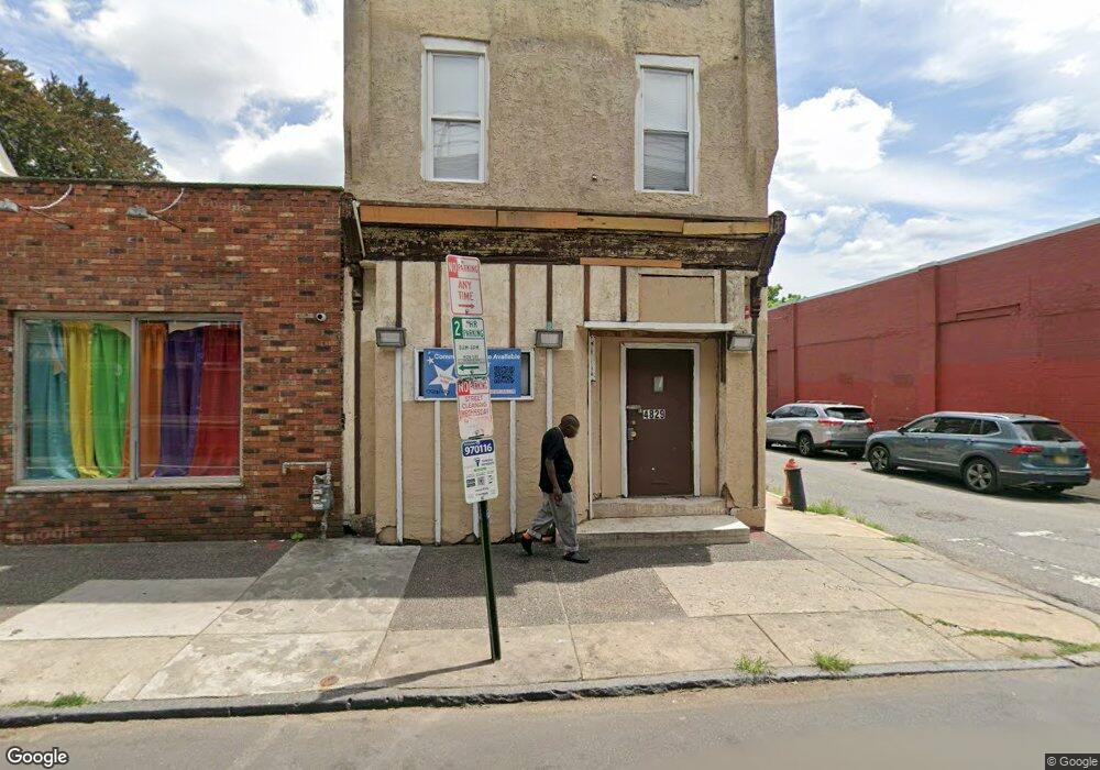
4829 Frankford Ave Philadelphia, PA 19124
Frankford NeighborhoodEstimated Value: $165,619
1
Bed
1
Bath
3,300
Sq Ft
$50/Sq Ft
Est. Value
About This Home
This home is located at 4829 Frankford Ave, Philadelphia, PA 19124 and is currently estimated at $165,619, approximately $50 per square foot. 4829 Frankford Ave is a home located in Philadelphia County with nearby schools including Harding Warren G Middle School, Frankford High School, and Mastery Schools Smedley Elementary.
Ownership History
Date
Name
Owned For
Owner Type
Purchase Details
Closed on
Jun 23, 2020
Sold by
Hill Tyrone
Bought by
Fw Holdings Llc
Current Estimated Value
Purchase Details
Closed on
Apr 17, 2019
Sold by
Estate Of Richard D Smith
Bought by
Hill Tyrone
Purchase Details
Closed on
Dec 30, 2002
Sold by
Bloom Joseph and First Union National Bank
Bought by
Smith Richard D
Purchase Details
Closed on
Sep 23, 2002
Sold by
Bloom Joseph and Heard Goggan Blair Williams
Bought by
Smith Richard D
Create a Home Valuation Report for This Property
The Home Valuation Report is an in-depth analysis detailing your home's value as well as a comparison with similar homes in the area
Home Values in the Area
Average Home Value in this Area
Purchase History
| Date | Buyer | Sale Price | Title Company |
|---|---|---|---|
| Fw Holdings Llc | $110,000 | Platinum Abstract Co Llc | |
| Hill Tyrone | $67,000 | None Available | |
| Smith Richard D | $27,300 | -- | |
| Smith Richard D | $5,200 | -- |
Source: Public Records
Tax History Compared to Growth
Tax History
| Year | Tax Paid | Tax Assessment Tax Assessment Total Assessment is a certain percentage of the fair market value that is determined by local assessors to be the total taxable value of land and additions on the property. | Land | Improvement |
|---|---|---|---|---|
| 2026 | $1,524 | $128,500 | $25,700 | $102,800 |
| 2025 | $1,524 | $128,500 | $25,700 | $102,800 |
| 2024 | $1,524 | $128,500 | $25,700 | $102,800 |
| 2023 | $1,524 | $108,900 | $21,700 | $87,200 |
| 2022 | $1,985 | $108,900 | $21,700 | $87,200 |
| 2021 | $1,985 | $0 | $0 | $0 |
| 2020 | $1,985 | $0 | $0 | $0 |
| 2019 | $1,965 | $0 | $0 | $0 |
| 2018 | $1,909 | $0 | $0 | $0 |
| 2017 | $2,268 | $0 | $0 | $0 |
| 2016 | $2,171 | $0 | $0 | $0 |
| 2015 | $2,171 | $0 | $0 | $0 |
| 2014 | -- | $162,000 | $17,200 | $144,800 |
| 2012 | -- | $10,560 | $5,620 | $4,940 |
Source: Public Records
Map
Nearby Homes
- 1615 Fillmore St
- 1636 Fillmore St
- 4839 Griscom St
- 1629 Foulkrod St
- 4814 Griscom St
- 1519 Foulkrod St
- 4735 Frankford Ave
- 1515 Foulkrod St
- 1688 Fillmore St
- 4734 44 Oxford Ave
- 4925 Penn St
- 4941 Penn St
- 4843 Duffield St
- 4712 Griscom St
- 1636 Margaret St
- 1626 Margaret St
- 4720 Penn St
- 5020 Griscom St
- 1516 Arrott St
- 4943 Duffield St
- 4831 Frankford Ave
- 1609 Fillmore St
- 1611 Fillmore St
- 1613 Fillmore St
- 1617 Fillmore St
- 1619 Fillmore St
- 1619 Fillmore St Unit 1
- 1619 Fillmore St Unit 2
- 1618 Fillmore St
- 1621 Fillmore St
- 4834 Frankford Ave Unit 3RD FL
- 4834 Frankford Ave Unit 2ND FL
- 4834 Frankford Ave
- 1623 Fillmore St Unit 1
- 1623 Fillmore St Unit 2ND FL
- 1623 Fillmore St
- 4838 Frankford Ave
- 4819 Frankford Ave
- 1625 Fillmore St
- 4832 Frankford Ave