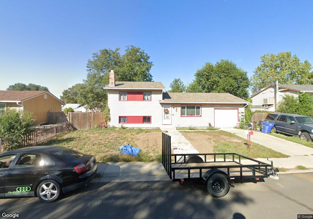
483 Cedar Ave Brighton, CO 80601
Estimated Value: $366,000 - $415,000
3
Beds
1
Bath
1,349
Sq Ft
$290/Sq Ft
Est. Value
About This Home
This home is located at 483 Cedar Ave, Brighton, CO 80601 and is currently estimated at $391,723, approximately $290 per square foot. 483 Cedar Ave is a home located in Adams County with nearby schools including South Elementary School, Vikan Middle School, and Riverdale Ridge High School.
Ownership History
Date
Name
Owned For
Owner Type
Purchase Details
Closed on
Aug 8, 2008
Sold by
Hud
Bought by
Collier Mikell
Current Estimated Value
Home Financials for this Owner
Home Financials are based on the most recent Mortgage that was taken out on this home.
Original Mortgage
$103,050
Outstanding Balance
$66,960
Interest Rate
6.47%
Mortgage Type
FHA
Estimated Equity
$324,763
Purchase Details
Closed on
Mar 10, 2008
Sold by
Clark Barbara Ann
Bought by
Secretary Of Hud
Create a Home Valuation Report for This Property
The Home Valuation Report is an in-depth analysis detailing your home's value as well as a comparison with similar homes in the area
Home Values in the Area
Average Home Value in this Area
Purchase History
| Date | Buyer | Sale Price | Title Company |
|---|---|---|---|
| Collier Mikell | $97,000 | Wtg | |
| Secretary Of Hud | -- | None Available |
Source: Public Records
Mortgage History
| Date | Status | Borrower | Loan Amount |
|---|---|---|---|
| Open | Collier Mikell | $103,050 |
Source: Public Records
Tax History
| Year | Tax Paid | Tax Assessment Tax Assessment Total Assessment is a certain percentage of the fair market value that is determined by local assessors to be the total taxable value of land and additions on the property. | Land | Improvement |
|---|---|---|---|---|
| 2025 | $2,455 | $24,690 | $5,850 | $18,840 |
| 2024 | $2,455 | $22,690 | $5,380 | $17,310 |
| 2023 | $2,444 | $25,910 | $5,410 | $20,500 |
| 2022 | $2,369 | $21,570 | $5,420 | $16,150 |
| 2021 | $2,221 | $21,570 | $5,420 | $16,150 |
| 2020 | $1,885 | $19,090 | $5,430 | $13,660 |
| 2019 | $1,887 | $19,090 | $5,430 | $13,660 |
| 2018 | $1,420 | $14,360 | $5,400 | $8,960 |
| 2017 | $1,418 | $14,360 | $5,400 | $8,960 |
| 2016 | $1,079 | $10,890 | $2,630 | $8,260 |
| 2015 | $1,077 | $10,890 | $2,630 | $8,260 |
| 2014 | -- | $9,600 | $2,150 | $7,450 |
Source: Public Records
Map
Nearby Homes
- 362 Dogwood Ave
- 677 Mockingbird St
- 727 Mockingbird St
- 239 Miller Ave
- 765 S 1st Ave
- 475 S 2nd Ave
- 475 S 2nd Ave Unit Plot 1
- 230 Ash Ave Unit 4
- 846 Mockingbird Ln
- 892 Mockingbird Ln
- 303 S 2nd Ave
- 544 S 3rd Ave
- 141 E Bromley Ln
- 648 S 3rd Ave
- 204 E Egbert St
- 219 S 3rd Ave
- 617 S 5th Ave
- 1085 Mockingbird St
- 135 S 3rd Ave
- 660 S 5th Ave
- 473 Cedar Ave
- 493 Cedar Ave
- 484 Dogwood Ave
- 474 Dogwood Ave
- 494 Dogwood Ave
- 463 Cedar Ave
- 486 Cedar Ave
- 462 Cedar Ave
- 464 Dogwood Ave
- 428 W Jessup St
- 432 W Jessup St
- 424 W Jessup St
- 453 Cedar Ave
- 454 Dogwood Ave
- 480 Cedar Ave
- 485 Dogwood Ave
- 468 Cedar Ave
- 475 Dogwood Ave
- 495 Dogwood Ave
- 436 W Jessup St
Your Personal Tour Guide
Ask me questions while you tour the home.