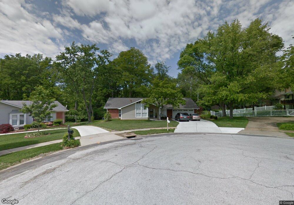
483 Manorcrest Ln Ballwin, MO 63011
Estimated Value: $404,197 - $445,000
4
Beds
3
Baths
1,836
Sq Ft
$229/Sq Ft
Est. Value
About This Home
This home is located at 483 Manorcrest Ln, Ballwin, MO 63011 and is currently estimated at $421,049, approximately $229 per square foot. 483 Manorcrest Ln is a home located in St. Louis County with nearby schools including Henry Elementary School, Parkway West Middle School, and Parkway West High School.
Ownership History
Date
Name
Owned For
Owner Type
Purchase Details
Closed on
May 18, 2011
Sold by
Everingham Sandra Sue and Everingham Charlie
Bought by
Bacon Richard and Bacon Jeane
Current Estimated Value
Home Financials for this Owner
Home Financials are based on the most recent Mortgage that was taken out on this home.
Original Mortgage
$156,000
Outstanding Balance
$108,762
Interest Rate
4.95%
Mortgage Type
Purchase Money Mortgage
Estimated Equity
$312,287
Purchase Details
Closed on
Oct 3, 2002
Sold by
Schneider Alan J and Schneider Sandra Sue
Bought by
Schneider Sandra Sue
Home Financials for this Owner
Home Financials are based on the most recent Mortgage that was taken out on this home.
Original Mortgage
$90,000
Interest Rate
6.09%
Create a Home Valuation Report for This Property
The Home Valuation Report is an in-depth analysis detailing your home's value as well as a comparison with similar homes in the area
Home Values in the Area
Average Home Value in this Area
Purchase History
| Date | Buyer | Sale Price | Title Company |
|---|---|---|---|
| Bacon Richard | $196,000 | None Available | |
| Schneider Sandra Sue | -- | -- |
Source: Public Records
Mortgage History
| Date | Status | Borrower | Loan Amount |
|---|---|---|---|
| Open | Bacon Richard | $156,000 | |
| Previous Owner | Schneider Sandra Sue | $90,000 |
Source: Public Records
Tax History
| Year | Tax Paid | Tax Assessment Tax Assessment Total Assessment is a certain percentage of the fair market value that is determined by local assessors to be the total taxable value of land and additions on the property. | Land | Improvement |
|---|---|---|---|---|
| 2025 | $4,656 | $68,460 | $26,580 | $41,880 |
| 2024 | $4,656 | $71,710 | $15,660 | $56,050 |
| 2023 | $4,656 | $71,710 | $15,660 | $56,050 |
| 2022 | $4,317 | $60,350 | $17,390 | $42,960 |
| 2021 | $4,291 | $60,350 | $17,390 | $42,960 |
| 2020 | $3,971 | $53,360 | $17,390 | $35,970 |
| 2019 | $3,924 | $53,360 | $17,390 | $35,970 |
| 2018 | $3,521 | $44,260 | $15,660 | $28,600 |
| 2017 | $3,480 | $44,260 | $15,660 | $28,600 |
| 2016 | $3,584 | $43,230 | $11,310 | $31,920 |
| 2015 | $3,747 | $43,230 | $11,310 | $31,920 |
| 2014 | $3,179 | $40,870 | $7,370 | $33,500 |
Source: Public Records
Map
Nearby Homes
- 490 Maymont Dr
- 505 Glenmeadow Dr
- 500 Kingridge Dr
- 203 Morewood Dr
- 426 Brooktree Dr
- 277 Oak Path Dr
- 502 Iron Lantern Dr
- 569 Highland Ridge Dr
- 202 Wildbrier Dr
- 909 Dutch Mill Dr
- 114 Lea Meadows Dr
- 718 Chancellor Heights Dr
- 449 Wildwood Pkwy
- 103 Calico Ln
- 828 Windmill Dr
- 102 Five Meadows Ln
- 724 Clayton Corners Dr
- 718 Savannah Crossing Way
- 1022 Julianna Dr
- 2455 Clayborn Dr Unit 2455
- 481 Manorcrest Ln
- 475 Ironwood Dr
- 5 Silvercreek Ln
- 479 Ironwood Dr
- 476 Manorcrest Ln
- 4 Silvercreek Ln
- 478 Manorcrest Ln
- 6 Silvercreek Ln
- 482 Ironwood Dr
- 484 Ironwood Dr
- 481 Ironwood Dr
- 486 Ironwood Dr
- 482 Manorcrest Ln
- 3 Silvercreek Ln
- 472 Hillbrook Dr
- 474 Hillbrook Dr
- 475 Maymont Dr
- 477 Maymont Dr
- 7 Silvercreek Ln
- 476 Hillbrook Dr
Your Personal Tour Guide
Ask me questions while you tour the home.