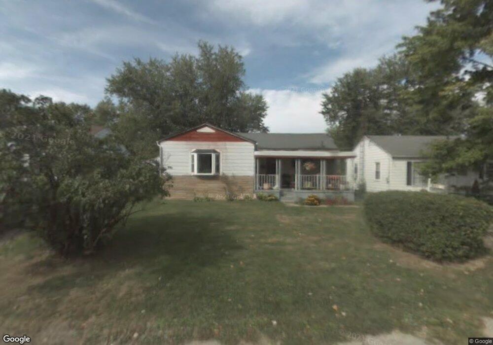
483 Stark St Mansfield, OH 44903
Estimated Value: $63,000 - $90,000
2
Beds
1
Bath
972
Sq Ft
$75/Sq Ft
Est. Value
About This Home
This home is located at 483 Stark St, Mansfield, OH 44903 and is currently estimated at $72,937, approximately $75 per square foot. 483 Stark St is a home located in Richland County with nearby schools including Foundation Academy, Mansfield Elective Academy, and Goal Digital Academy.
Ownership History
Date
Name
Owned For
Owner Type
Purchase Details
Closed on
Dec 18, 1996
Sold by
Corey Doris
Bought by
Bradley Mary A
Current Estimated Value
Home Financials for this Owner
Home Financials are based on the most recent Mortgage that was taken out on this home.
Original Mortgage
$27,160
Outstanding Balance
$2,771
Interest Rate
7.74%
Mortgage Type
FHA
Estimated Equity
$70,166
Purchase Details
Closed on
Jan 1, 1987
Create a Home Valuation Report for This Property
The Home Valuation Report is an in-depth analysis detailing your home's value as well as a comparison with similar homes in the area
Home Values in the Area
Average Home Value in this Area
Purchase History
| Date | Buyer | Sale Price | Title Company |
|---|---|---|---|
| Bradley Mary A | $26,900 | -- | |
| -- | $11,000 | -- |
Source: Public Records
Mortgage History
| Date | Status | Borrower | Loan Amount |
|---|---|---|---|
| Open | Bradley Mary A | $27,160 |
Source: Public Records
Tax History Compared to Growth
Tax History
| Year | Tax Paid | Tax Assessment Tax Assessment Total Assessment is a certain percentage of the fair market value that is determined by local assessors to be the total taxable value of land and additions on the property. | Land | Improvement |
|---|---|---|---|---|
| 2024 | $688 | $14,360 | $1,700 | $12,660 |
| 2023 | $688 | $14,360 | $1,700 | $12,660 |
| 2022 | $655 | $11,470 | $1,540 | $9,930 |
| 2021 | $660 | $11,470 | $1,540 | $9,930 |
| 2020 | $675 | $11,470 | $1,540 | $9,930 |
| 2019 | $748 | $11,470 | $1,540 | $9,930 |
| 2018 | $738 | $11,470 | $1,540 | $9,930 |
| 2017 | $787 | $11,470 | $1,540 | $9,930 |
| 2016 | $855 | $13,240 | $2,440 | $10,800 |
| 2015 | $817 | $13,240 | $2,440 | $10,800 |
| 2014 | $806 | $13,240 | $2,440 | $10,800 |
| 2012 | $309 | $13,250 | $2,570 | $10,680 |
Source: Public Records
Map
Nearby Homes
- 0 State Route 314 Unit 9069650
- 0 State Route 314 Unit 9067316
- 0 State Route 314 Unit 225021979
- 512 Burns St
- 480 Mcpherson St
- 269 Parkway Dr
- 450 Tracy St
- 0 Highway 30
- 641 Averill Ave
- 426 Mcpherson St
- 237 Helen Ave
- 170 Western Ave
- 185 Rowland Ave
- 212 Penn Ave
- 0 Voegele Ave Unit Lot 6048, 6049, 6
- 741 Burger Ave
- 362-364 W 6th St
- 283 Bulkley Ave
- 371 Bell St
- 96 Helen Ave
- 479 Stark St
- 489 Stark St
- 473 Stark St
- 480 Collins Dr
- 486 Collins Dr
- 474 Collins Dr
- 469 Stark St
- 482 Stark St
- 488 Stark St
- 478 Stark St
- 468 Collins Dr
- 657 Burns St
- 663 Burns St
- 0 State Route 314 Unit 9066294
- 0 Sturges Ave Unit 403041
- 0 State Route 314 Unit 9057767
- 0 State Route 314 Unit 9032037
- 0 State Route 314 Unit 9032261
- 0 State Route 314 Unit 9033932
- 0 State Route 314 Unit 9034466