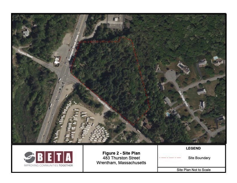
483 Thurston St Wrentham, MA 02093
Estimated payment $12,873/month
Highlights
- Medical Services
- Property is near public transit
- Shops
- Delaney Elementary School Rated A
- No HOA
About This Lot
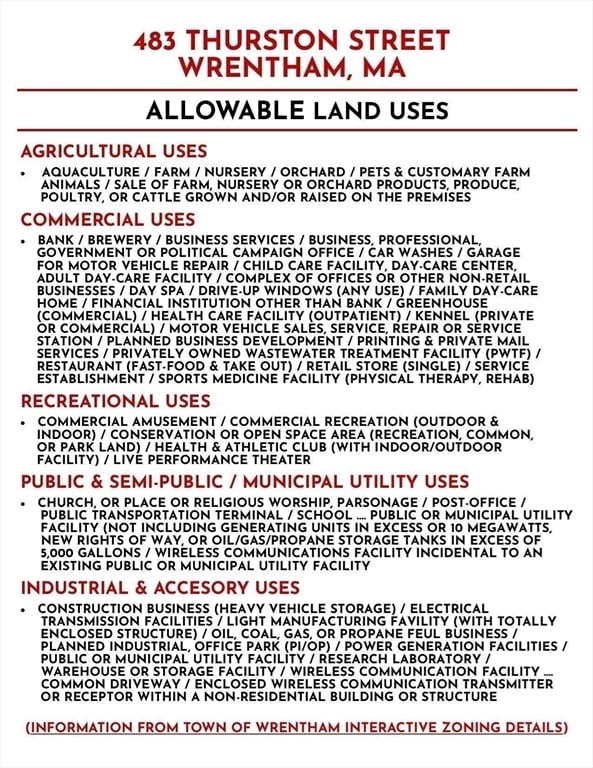
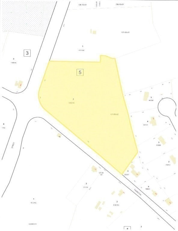
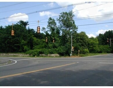
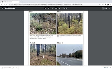
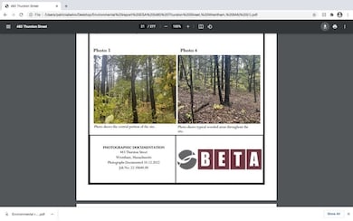
Great Value - New Engineering Assessment attached . Corner Route ONE and Thurston St., - C-1S Route 1 South District - IDEAL COMMERCIAL LAND - RT 1 NORTH and THURSTON ST- WRENTHAM - 6.82 ACRES - AT TRAFFIC LIGHT INTERSECTION - 2 MILES SOUTH OF PATRIOT PLACE - GILLETTE STADIUM - SOUTHERN EXPOSURE. Water and electricity on street - Prime Location - Easy to RT 95 and 495 via 4 wy intersection. Environmental Engineering Report is available upon request. So many uses for this land are allowed. Uses as per C-1S zoning as per town site pending approval for an individual project: Restaurant or fast food, drive up window, motel, hotel, bank, medical facility, car service repair, sale of trailers, motor vehicles, child care, office building, brewery, drive up window, car wash, recreation facility, amusement, warehouse, construction business, heavy equipment storage, school, place of worship, sale of nursery products this is just some of the uses.

Property Details
Property Type
- Land
Est. Annual Taxes
- $8,727
Lot Details
- 6.82 Acre Lot
- Property is zoned Commercial
Additional Features
- Property is near public transit
- Private Sewer
Listing and Financial Details
- Assessor Parcel Number 3503369
Community Details
Overview
- No Home Owners Association
Amenities
- Medical Services
- Shops
Recreation
- Electricity Available at Street
Map
Home Values in the Area
Average Home Value in this Area
Tax History
| Year | Tax Paid | Tax Assessment Tax Assessment Total Assessment is a certain percentage of the fair market value that is determined by local assessors to be the total taxable value of land and additions on the property. | Land | Improvement |
|---|---|---|---|---|
| 2025 | $8,802 | $502,400 | $502,400 | $0 |
| 2024 | $8,727 | $502,400 | $502,400 | $0 |
| 2023 | $8,460 | $502,400 | $502,400 | $0 |
| 2022 | $7,257 | $399,200 | $399,200 | $0 |
| 2021 | $6,954 | $399,200 | $399,200 | $0 |
| 2020 | $6,876 | $373,900 | $373,900 | $0 |
| 2019 | $6,820 | $373,900 | $373,900 | $0 |
| 2018 | $6,827 | $374,100 | $374,100 | $0 |
| 2017 | $6,878 | $366,800 | $366,800 | $0 |
| 2016 | $6,667 | $359,400 | $359,400 | $0 |
| 2015 | $6,540 | $348,600 | $348,600 | $0 |
| 2014 | $6,340 | $341,800 | $341,800 | $0 |
Property History
| Date | Event | Price | List to Sale | Price per Sq Ft |
|---|---|---|---|---|
| 06/02/2025 06/02/25 | Price Changed | $2,300,000 | -14.8% | -- |
| 04/22/2025 04/22/25 | Price Changed | $2,698,000 | -18.1% | -- |
| 09/16/2024 09/16/24 | For Sale | $3,295,000 | 0.0% | -- |
| 09/12/2024 09/12/24 | Off Market | $3,295,000 | -- | -- |
| 06/26/2024 06/26/24 | Price Changed | $3,295,000 | +3.1% | -- |
| 06/26/2024 06/26/24 | Price Changed | $3,195,000 | -19.1% | -- |
| 02/20/2024 02/20/24 | Price Changed | $3,950,000 | -6.0% | -- |
| 05/29/2023 05/29/23 | For Sale | $4,200,000 | -- | -- |
Purchase History
| Date | Type | Sale Price | Title Company |
|---|---|---|---|
| Deed | $55,000 | -- |
Source: MLS Property Information Network (MLS PIN)
MLS Number: 73116962
APN: WREN-000007O-000005-000002
Disclaimer: Certain information contained herein is derived from information provided by parties other than Homes.com. All information provided is deemed reliable, but is not guaranteed to be accurate and should be independently verified.
![]() The property listing data and information, or the Images, set forth herein were provided to MLS Property Information Network, Inc. from third party sources, including sellers, lessors and public records, and were compiled by MLS Property Information Network, Inc. The property listing data and information, and the Images, are for the personal, non-commercial use of consumers having a good faith interest in purchasing or leasing listed properties of the type displayed to them and may not be used for any purpose other than to identify prospective properties which such consumers may have a good faith interest in purchasing or leasing. MLS Property Information Network, Inc. and its subscribers disclaim any and all representations and warranties as to the accuracy of the property listing data and information, or as to the accuracy of any of the Images, set forth herein.
The property listing data and information, or the Images, set forth herein were provided to MLS Property Information Network, Inc. from third party sources, including sellers, lessors and public records, and were compiled by MLS Property Information Network, Inc. The property listing data and information, and the Images, are for the personal, non-commercial use of consumers having a good faith interest in purchasing or leasing listed properties of the type displayed to them and may not be used for any purpose other than to identify prospective properties which such consumers may have a good faith interest in purchasing or leasing. MLS Property Information Network, Inc. and its subscribers disclaim any and all representations and warranties as to the accuracy of the property listing data and information, or as to the accuracy of any of the Images, set forth herein.
- 120 Hawes St
- 65 Pond St
- 362 East St
- 80 Mill St
- 319 Taunton St
- 11 Goodwin Dr
- 1 Lorraine Metcalf Dr
- 270 Dedham St
- 25 Foxboro Rd
- 9 Oak Dr
- 10 Nature View Dr
- 15 Nature View Dr
- 16 Treasure Island Rd
- 406 South St
- 160 Washington St Unit 36
- 160 Washington St Unit 65
- Lot 1 - Blueberry 2 Car Plan at King Philip Estates
- Lot 8 - Blueberry 2 Car Plan at King Philip Estates
- Lot 6 - Blueberry 3 Car Plan at King Philip Estates
- Lot 2 - Camden 2 Car Plan at King Philip Estates
- 23 Ames Ave Unit A
- 50 Ledgeview Way
- 4 West St Unit 6
- 28 Chestnut St
- 29 Wall St
- 55 Walnut St
- 29 Wall St Unit 210
- 29 Wall St Unit 204
- 34 Capone Rd
- 157 Central St Unit 2
- 41 -43 Mechanic St Unit 41
- 71 Messenger St
- 18 Taunton St Unit 60
- 7 Taunton St
- 10 Fisher St
- 656 Franklin St
- 400 Foxborough Blvd
- 85 Washington St
- 3-20 Fuller Rd
- 792 West St