Estimated Value: $480,000 - $629,000
2
Beds
2
Baths
1,552
Sq Ft
$361/Sq Ft
Est. Value
About This Home
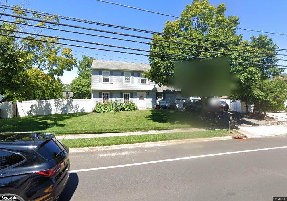
This home is located at 484 Adamston Rd, Brick, NJ 08723 and is currently estimated at $559,575, approximately $360 per square foot. 484 Adamston Rd is a home located in Ocean County with nearby schools including Osbornville Elementary School, Lake Riviera Middle School, and Brick Township High School.
Ownership History
Date
Name
Owned For
Owner Type
Purchase Details
Closed on
Nov 21, 2006
Sold by
Johnson Edward J and Walker Debra A
Bought by
Vargas Kirby and Vargas Betty
Current Estimated Value
Home Financials for this Owner
Home Financials are based on the most recent Mortgage that was taken out on this home.
Original Mortgage
$354,438
Interest Rate
6.25%
Mortgage Type
FHA
Purchase Details
Closed on
Sep 7, 2004
Sold by
Wademan Robert D and Wademan Sherry A
Bought by
Johnson Edward J and Walker Debra A
Home Financials for this Owner
Home Financials are based on the most recent Mortgage that was taken out on this home.
Original Mortgage
$297,000
Interest Rate
6.08%
Mortgage Type
Fannie Mae Freddie Mac
Purchase Details
Closed on
Oct 31, 1994
Sold by
Stemark Assoc
Bought by
Wademan Robert and Wademan Sherry
Home Financials for this Owner
Home Financials are based on the most recent Mortgage that was taken out on this home.
Original Mortgage
$113,000
Interest Rate
8.71%
Mortgage Type
FHA
Create a Home Valuation Report for This Property
The Home Valuation Report is an in-depth analysis detailing your home's value as well as a comparison with similar homes in the area
Home Values in the Area
Average Home Value in this Area
Purchase History
| Date | Buyer | Sale Price | Title Company |
|---|---|---|---|
| Vargas Kirby | $360,000 | Lawyers Title Insurance Corp | |
| Johnson Edward J | $330,000 | Premier Abstract & Title Age | |
| Wademan Robert | $113,000 | -- |
Source: Public Records
Mortgage History
| Date | Status | Borrower | Loan Amount |
|---|---|---|---|
| Previous Owner | Vargas Kirby | $354,438 | |
| Previous Owner | Johnson Edward J | $297,000 | |
| Previous Owner | Wademan Robert | $113,000 |
Source: Public Records
Tax History Compared to Growth
Tax History
| Year | Tax Paid | Tax Assessment Tax Assessment Total Assessment is a certain percentage of the fair market value that is determined by local assessors to be the total taxable value of land and additions on the property. | Land | Improvement |
|---|---|---|---|---|
| 2025 | $6,969 | $269,800 | $126,000 | $143,800 |
| 2024 | $6,624 | $269,800 | $126,000 | $143,800 |
| 2023 | $6,537 | $269,800 | $126,000 | $143,800 |
| 2022 | $6,537 | $269,800 | $126,000 | $143,800 |
| 2021 | $6,400 | $269,800 | $126,000 | $143,800 |
| 2020 | $6,319 | $269,800 | $126,000 | $143,800 |
| 2019 | $6,213 | $269,800 | $126,000 | $143,800 |
| 2018 | $6,071 | $269,800 | $126,000 | $143,800 |
| 2017 | $5,906 | $269,800 | $126,000 | $143,800 |
| 2016 | $5,876 | $269,800 | $126,000 | $143,800 |
| 2015 | $5,722 | $269,800 | $126,000 | $143,800 |
| 2014 | $5,677 | $269,800 | $126,000 | $143,800 |
Source: Public Records
Map
Nearby Homes
- 484 Bara St
- 0 Mantoloking Rd Unit 11584872
- 470 Mantoloking Rd
- 417 Mamie Dr
- 507 Riverside Dr S
- 474 Burnt Bark Rd
- 463 Mamie Dr
- 455 Mamie Dr
- 10 Riverside Dr W
- 621 Preston St
- 618 Leanora St
- 00 Mantoloking Rd
- VZ0 Mantoloking Rd
- 570 Mantoloking Rd
- 15 Hulse Landing Rd
- 553 Kingfisher Cr
- 553 Kingfisher Cir
- 53 Country Club Ct
- 82 E View Dr
- 458 Drum Point Rd
- 488 Adamston Rd
- 480 Adamston Rd
- 493 Dorothy Place
- 481 Adamston Rd
- 489 Dorothy Place
- 480 Bara St
- 482 Bara St
- 492 Adamston Rd
- 495 Dorothy Place
- 485 Dorothy Place
- 497 Dorothy Place
- 444 Adamston Rd
- 496 Adamston Rd
- 481 Bara St
- 488 Dorothy Place
- 476 Adamston Rd
- 499 Dorothy Place
- 483 Bara St
- 492 Dorothy Place
- 547 Dorothy Place