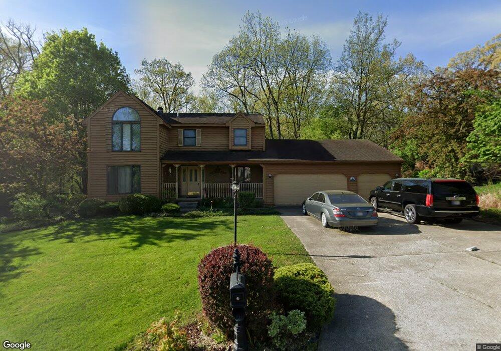
484 Ashford Ln Valparaiso, IN 46385
Porter County NeighborhoodEstimated Value: $464,000 - $535,000
4
Beds
4
Baths
2,801
Sq Ft
$176/Sq Ft
Est. Value
About This Home
This home is located at 484 Ashford Ln, Valparaiso, IN 46385 and is currently estimated at $493,994, approximately $176 per square foot. 484 Ashford Ln is a home located in Porter County with nearby schools including Union Township Middle School and Wheeler High School.
Ownership History
Date
Name
Owned For
Owner Type
Purchase Details
Closed on
May 6, 2021
Sold by
Corns Robert and Corns Robert Alan
Bought by
Corns Robert Alan and Corns Carisse Marie
Current Estimated Value
Home Financials for this Owner
Home Financials are based on the most recent Mortgage that was taken out on this home.
Original Mortgage
$1,435,000
Outstanding Balance
$1,300,468
Interest Rate
3.1%
Mortgage Type
New Conventional
Estimated Equity
-$806,474
Purchase Details
Closed on
Jan 22, 2007
Sold by
Bartolac Thomas F and Bartolac Lucille B
Bought by
Gray Rudy V and Gray Rosetta O
Home Financials for this Owner
Home Financials are based on the most recent Mortgage that was taken out on this home.
Original Mortgage
$230,000
Interest Rate
6.22%
Mortgage Type
Purchase Money Mortgage
Create a Home Valuation Report for This Property
The Home Valuation Report is an in-depth analysis detailing your home's value as well as a comparison with similar homes in the area
Home Values in the Area
Average Home Value in this Area
Purchase History
| Date | Buyer | Sale Price | Title Company |
|---|---|---|---|
| Corns Robert Alan | -- | Chicago Title Co Llc | |
| Gray Rudy V | -- | Ticor Title Insurance |
Source: Public Records
Mortgage History
| Date | Status | Borrower | Loan Amount |
|---|---|---|---|
| Open | Corns Robert Alan | $1,435,000 | |
| Closed | Gray Rudy V | $230,000 |
Source: Public Records
Tax History Compared to Growth
Tax History
| Year | Tax Paid | Tax Assessment Tax Assessment Total Assessment is a certain percentage of the fair market value that is determined by local assessors to be the total taxable value of land and additions on the property. | Land | Improvement |
|---|---|---|---|---|
| 2024 | $3,495 | $460,100 | $73,100 | $387,000 |
| 2023 | $3,355 | $445,100 | $69,600 | $375,500 |
| 2022 | $3,150 | $402,200 | $69,600 | $332,600 |
| 2021 | $2,968 | $360,300 | $69,600 | $290,700 |
| 2020 | $2,896 | $342,800 | $63,200 | $279,600 |
| 2019 | $2,746 | $322,900 | $63,200 | $259,700 |
| 2018 | $2,821 | $307,100 | $63,200 | $243,900 |
| 2017 | $2,531 | $306,100 | $63,200 | $242,900 |
| 2016 | $2,510 | $304,100 | $59,700 | $244,400 |
| 2014 | $2,519 | $295,900 | $56,400 | $239,500 |
| 2013 | -- | $312,400 | $63,700 | $248,700 |
Source: Public Records
Map
Nearby Homes
- 459 Amhurst Rd
- 194 Wexford Rd
- 464 Roxbury Rd
- 460 Roxbury Rd
- 454 Roxbury Rd
- 143 N 500 W
- 148 Timber Point Ct
- 459 Surrey Hill Ln
- 447 Scarborough Rd
- 220 N 500 W
- 175 Shorewood Dr
- 446 Surrey Hill Ln
- 149 Westchester Ln
- 419 Scarborough Rd
- 536 W Us Highway 30
- 397 Shorewood Ct
- 421 Chadwick Cir
- 528 W 100 N
- 122 Shorewood Dr
- 246 Pixley Ct