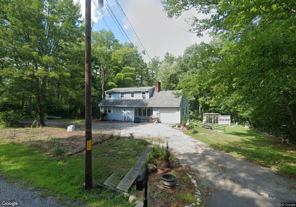
484 Hooksett Rd Auburn, NH 03032
Estimated Value: $532,000 - $605,000
3
Beds
3
Baths
1,714
Sq Ft
$332/Sq Ft
Est. Value
About This Home
This home is located at 484 Hooksett Rd, Auburn, NH 03032 and is currently estimated at $568,587, approximately $331 per square foot. 484 Hooksett Rd is a home located in Rockingham County with nearby schools including Auburn Village School, Pinkerton Academy, and Auburn Montessori School.
Ownership History
Date
Name
Owned For
Owner Type
Purchase Details
Closed on
Sep 29, 2009
Sold by
Chambers Beverly J
Bought by
Hudon Matthew
Current Estimated Value
Home Financials for this Owner
Home Financials are based on the most recent Mortgage that was taken out on this home.
Original Mortgage
$208,590
Interest Rate
5.31%
Mortgage Type
Purchase Money Mortgage
Create a Home Valuation Report for This Property
The Home Valuation Report is an in-depth analysis detailing your home's value as well as a comparison with similar homes in the area
Home Values in the Area
Average Home Value in this Area
Purchase History
We collect this data history from publicly available records. To have your information removed, we recommend requesting removal directly through your county’s website.
| Date | Buyer | Sale Price | Title Company |
|---|---|---|---|
| Hudon Matthew | $195,000 | -- |
Source: Public Records
Mortgage History
We collect this data history from publicly available records. To have your information removed, we recommend requesting removal directly through your county’s website.
| Date | Status | Borrower | Loan Amount |
|---|---|---|---|
| Open | Hudon Matthew | $213,131 | |
| Closed | Hudon Matthew | $208,590 |
Source: Public Records
Tax History
| Year | Tax Paid | Tax Assessment Tax Assessment Total Assessment is a certain percentage of the fair market value that is determined by local assessors to be the total taxable value of land and additions on the property. | Land | Improvement |
|---|---|---|---|---|
| 2025 | $6,446 | $464,400 | $172,700 | $291,700 |
| 2024 | $6,255 | $464,400 | $172,700 | $291,700 |
| 2023 | $5,856 | $464,400 | $172,700 | $291,700 |
| 2022 | $5,146 | $288,300 | $137,600 | $150,700 |
| 2021 | $5,230 | $288,300 | $137,600 | $150,700 |
| 2020 | $5,328 | $288,300 | $137,600 | $150,700 |
| 2019 | $5,451 | $289,800 | $137,600 | $152,200 |
| 2018 | $4,944 | $289,800 | $137,600 | $152,200 |
| 2017 | $85 | $248,800 | $140,400 | $108,400 |
| 2016 | $5,038 | $248,800 | $140,400 | $108,400 |
| 2015 | $5,153 | $248,800 | $140,400 | $108,400 |
| 2014 | $5,302 | $248,800 | $140,400 | $108,400 |
| 2013 | $4,821 | $246,100 | $140,400 | $105,700 |
Source: Public Records
Map
Nearby Homes
- 55 the Cliffs at Evergreen Cliffside Dr Unit 55
- 30 the Cliffs at Evergreen Cliffside Dr Unit 30
- 109 Harvard Ave
- 58 the Cliffs at Evergreen Dr Unit 58
- #50 the Cliffs at Evergreen Dr
- 41 the Cliffs at Evergreen Dr Unit 41
- 100 Dartmouth Dr
- 80 Dartmouth Dr
- 10 Harvard Ave
- 8 Flag Ct
- 209 Hooksett Rd
- 757 Hooksett Rd
- 5 Neal Ave
- 127 Hooksett Rd
- 71 Auburn Rd
- 686 Old Candia Rd
- 361 Chester Turnpike
- 192 Londonderry Turnpike
- 62 Shepherd Rd
- 100 Ledgewood Way
Your Personal Tour Guide
Ask me questions while you tour the home.