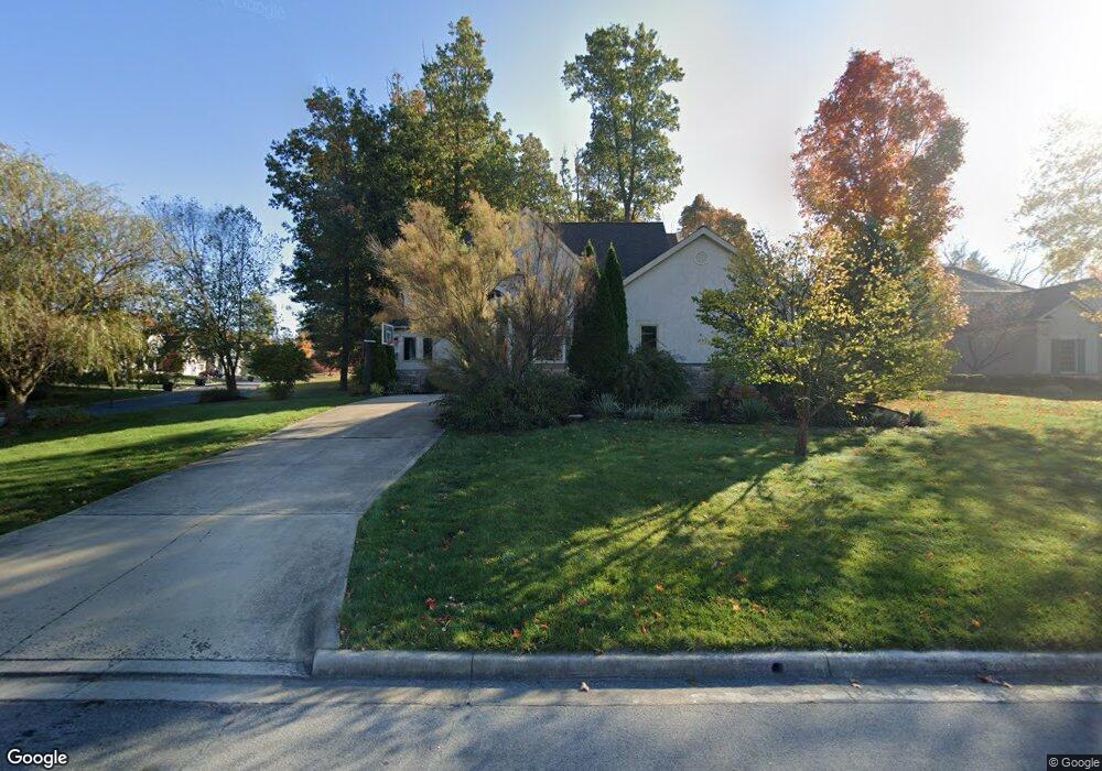
484 Maketewah Dr Delaware, OH 43015
Estimated Value: $584,000 - $752,000
4
Beds
3
Baths
3,372
Sq Ft
$196/Sq Ft
Est. Value
About This Home
This home is located at 484 Maketewah Dr, Delaware, OH 43015 and is currently estimated at $660,970, approximately $196 per square foot. 484 Maketewah Dr is a home located in Delaware County with nearby schools including Cheshire Elementary School, Hyatts Middle School, and Olentangy Berlin High School.
Ownership History
Date
Name
Owned For
Owner Type
Purchase Details
Closed on
May 13, 2002
Sold by
New Green Highlands Dev
Bought by
Charles Ranjit J S
Current Estimated Value
Home Financials for this Owner
Home Financials are based on the most recent Mortgage that was taken out on this home.
Original Mortgage
$300,700
Outstanding Balance
$117,462
Interest Rate
5.87%
Mortgage Type
New Conventional
Estimated Equity
$543,508
Create a Home Valuation Report for This Property
The Home Valuation Report is an in-depth analysis detailing your home's value as well as a comparison with similar homes in the area
Home Values in the Area
Average Home Value in this Area
Purchase History
| Date | Buyer | Sale Price | Title Company |
|---|---|---|---|
| Charles Ranjit J S | $92,500 | -- |
Source: Public Records
Mortgage History
| Date | Status | Borrower | Loan Amount |
|---|---|---|---|
| Open | Charles Ranjit J S | $300,700 |
Source: Public Records
Tax History Compared to Growth
Tax History
| Year | Tax Paid | Tax Assessment Tax Assessment Total Assessment is a certain percentage of the fair market value that is determined by local assessors to be the total taxable value of land and additions on the property. | Land | Improvement |
|---|---|---|---|---|
| 2024 | $10,604 | $191,700 | $33,080 | $158,620 |
| 2023 | $10,165 | $191,700 | $33,080 | $158,620 |
| 2022 | $10,204 | $151,870 | $24,500 | $127,370 |
| 2021 | $10,265 | $151,870 | $24,500 | $127,370 |
| 2020 | $10,314 | $151,870 | $24,500 | $127,370 |
| 2019 | $9,670 | $148,160 | $24,500 | $123,660 |
| 2018 | $9,714 | $148,160 | $24,500 | $123,660 |
| 2017 | $9,438 | $147,010 | $23,770 | $123,240 |
| 2016 | $10,239 | $147,010 | $23,770 | $123,240 |
| 2015 | $9,249 | $147,010 | $23,770 | $123,240 |
| 2014 | $9,374 | $147,010 | $23,770 | $123,240 |
| 2013 | $9,458 | $147,010 | $23,770 | $123,240 |
Source: Public Records
Map
Nearby Homes
- 144 Littondale Dr
- 81 Littondale Dr
- 120 Littondale Dr
- 38 Littondale Dr
- 347 Broad Furrows Ave
- Ashland Plan at Stockdale Farms
- Barclay Plan at Stockdale Farms
- Dover Plan at Stockdale Farms
- Bradford Plan at Stockdale Farms
- Brentwood Plan at Stockdale Farms
- Richmond Plan at Stockdale Farms
- Providence Plan at Stockdale Farms
- Linden Plan at Stockdale Farms
- Rockingham Plan at Stockdale Farms
- Charleston Plan at Stockdale Farms
- 784 Maketewah Dr
- Emmett Plan at Stockdale Farms - Designer Collection
- Winston Plan at Stockdale Farms - Designer Collection
- Carrington Plan at Stockdale Farms - Designer Collection
- Wyatt Plan at Stockdale Farms - Designer Collection
- 470 Maketewah Dr
- 527 Covered Bridge Dr
- 458 Maketewah Dr
- 549 Covered Bridge Dr
- 485 Maketewah Dr
- 499 Maketewah Dr
- 469 Maketewah Dr
- 444 Maketewah Dr
- 511 Maketewah Dr
- 563 Covered Bridge Dr
- 563 Covered Bridge Dr Unit 997
- 457 Maketewah Dr
- 534 Maketewah Dr
- 577 Covered Bridge Dr
- 432 Maketewah Dr
- 443 Maketewah Dr
- 560 Maketewah Dr
- 591 Covered Bridge Dr
- 586 Maketewah Dr
- 537 Maketewah Dr