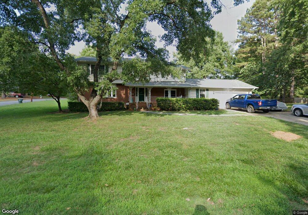
485 Crestside Dr SE Concord, NC 28025
Estimated Value: $439,000 - $461,846
4
Beds
3
Baths
2,523
Sq Ft
$177/Sq Ft
Est. Value
About This Home
This home is located at 485 Crestside Dr SE, Concord, NC 28025 and is currently estimated at $447,712, approximately $177 per square foot. 485 Crestside Dr SE is a home located in Cabarrus County with nearby schools including W.M. Irvin Elementary School, Concord Middle School, and Concord High School.
Ownership History
Date
Name
Owned For
Owner Type
Purchase Details
Closed on
Jun 20, 2014
Sold by
Mcpherson Judy
Bought by
Benkendorf Joseph E
Current Estimated Value
Home Financials for this Owner
Home Financials are based on the most recent Mortgage that was taken out on this home.
Original Mortgage
$165,300
Outstanding Balance
$126,108
Interest Rate
4.28%
Mortgage Type
New Conventional
Estimated Equity
$321,604
Purchase Details
Closed on
Dec 1, 1997
Bought by
Mcpherson Ronald L and Wife Judy
Create a Home Valuation Report for This Property
The Home Valuation Report is an in-depth analysis detailing your home's value as well as a comparison with similar homes in the area
Home Values in the Area
Average Home Value in this Area
Purchase History
| Date | Buyer | Sale Price | Title Company |
|---|---|---|---|
| Benkendorf Joseph E | $174,000 | None Available | |
| Mcpherson Ronald L | $170,000 | -- |
Source: Public Records
Mortgage History
| Date | Status | Borrower | Loan Amount |
|---|---|---|---|
| Open | Benkendorf Joseph E | $165,300 |
Source: Public Records
Tax History Compared to Growth
Tax History
| Year | Tax Paid | Tax Assessment Tax Assessment Total Assessment is a certain percentage of the fair market value that is determined by local assessors to be the total taxable value of land and additions on the property. | Land | Improvement |
|---|---|---|---|---|
| 2025 | $3,440 | $345,390 | $87,000 | $258,390 |
| 2024 | $3,440 | $345,390 | $87,000 | $258,390 |
| 2023 | $2,611 | $214,040 | $55,000 | $159,040 |
| 2022 | $2,611 | $214,040 | $55,000 | $159,040 |
| 2021 | $2,611 | $214,040 | $55,000 | $159,040 |
| 2020 | $2,611 | $214,040 | $55,000 | $159,040 |
| 2019 | $2,193 | $179,740 | $30,000 | $149,740 |
| 2018 | $2,157 | $179,740 | $30,000 | $149,740 |
| 2017 | $2,121 | $179,740 | $30,000 | $149,740 |
| 2016 | $1,258 | $171,720 | $30,000 | $141,720 |
| 2015 | $2,026 | $171,720 | $30,000 | $141,720 |
| 2014 | $2,026 | $171,720 | $30,000 | $141,720 |
Source: Public Records
Map
Nearby Homes
- 428 Spruce Place SE
- 467 Countrywood Place SE
- TBD Countrywood Place SE Unit 28
- 335 Summit Ct SE
- 315 Crestside Dr SE
- 230 Ravine Cir SE
- 192, 188, 196, 197 & Riverbirch Dr SE
- 208 Corban Ave SE
- 301 Rosemont Ave SE
- 209 Gene Ct SE
- 121 Louise Dr SE
- 65 Glendale Ave SE
- 590 Crestmont Dr SE
- 145 Deal St SE
- 522 Sunnyside Dr SE
- 60 Patton Ct SE
- 347 Valley Brook Ln SE Unit 39
- 135 Corban Ave SE
- 448 Union St S
- 374 Union St S
- 390 Knoll Ct SE
- 495 Crestside Dr SE
- 477 Crestside Dr SE
- 486 Crestside Dr SE
- 391 Knoll Ct SE
- 273 Brook Ave SE
- 478 Crestside Dr SE
- 496 Crestside Dr SE
- 496 Crestside Dr SE Unit 9
- 001 Foxwood Dr SE
- 467 Crestside Dr SE
- 393 Knoll Ct SE
- 383 Brook Ave SE
- 515 Crestside Dr SE
- 284 Charter Ct SE Unit 12
- 284 Charter Ct SE
- 468 Crestside Dr SE
- 280 Charter Ct SE Unit 13
- 280 Charter Ct SE
- Lot 1 Charter Ct