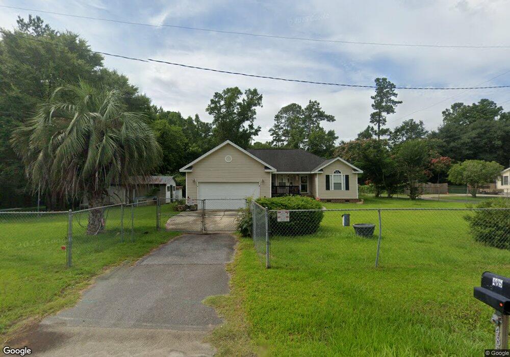
485 Embassy Dr Summerville, SC 29483
Estimated Value: $329,000 - $403,763
3
Beds
2
Baths
1,685
Sq Ft
$221/Sq Ft
Est. Value
About This Home
This home is located at 485 Embassy Dr, Summerville, SC 29483 and is currently estimated at $373,191, approximately $221 per square foot. 485 Embassy Dr is a home located in Dorchester County with nearby schools including Newington Elementary School, Charles B. DuBose Middle School, and Summerville High School.
Ownership History
Date
Name
Owned For
Owner Type
Purchase Details
Closed on
Oct 22, 2021
Sold by
Stone Linda and Stone Linda Kaye
Bought by
Shuster Dealla D
Current Estimated Value
Purchase Details
Closed on
Apr 2, 2021
Sold by
Young Janice J and Estate Of Nukie W Grooms
Bought by
Stone Linda
Purchase Details
Closed on
Sep 11, 2008
Sold by
Stone Linda Kaye
Bought by
Shuster Dealla D
Purchase Details
Closed on
Jul 30, 2007
Sold by
Shuster Dealla D and Scott Remona G
Bought by
Stone Linda Kaye
Create a Home Valuation Report for This Property
The Home Valuation Report is an in-depth analysis detailing your home's value as well as a comparison with similar homes in the area
Home Values in the Area
Average Home Value in this Area
Purchase History
| Date | Buyer | Sale Price | Title Company |
|---|---|---|---|
| Shuster Dealla D | -- | None Available | |
| Stone Linda | -- | None Available | |
| Stone Linda | -- | None Listed On Document | |
| Shuster Dealla D | -- | -- | |
| Stone Linda Kaye | -- | Attorney |
Source: Public Records
Tax History Compared to Growth
Tax History
| Year | Tax Paid | Tax Assessment Tax Assessment Total Assessment is a certain percentage of the fair market value that is determined by local assessors to be the total taxable value of land and additions on the property. | Land | Improvement |
|---|---|---|---|---|
| 2024 | $1,008 | $15,536 | $4,466 | $11,070 |
| 2023 | $1,008 | $8,656 | $2,620 | $6,036 |
| 2022 | $863 | $6,270 | $950 | $5,320 |
| 2021 | $863 | $6,270 | $950 | $5,320 |
| 2020 | $786 | $5,460 | $830 | $4,630 |
| 2019 | $762 | $5,460 | $830 | $4,630 |
| 2018 | $640 | $5,460 | $830 | $4,630 |
| 2017 | $939 | $5,460 | $830 | $4,630 |
| 2016 | $929 | $5,460 | $830 | $4,630 |
| 2015 | $926 | $5,460 | $830 | $4,630 |
| 2014 | -- | $203,100 | $0 | $0 |
| 2013 | -- | $8,120 | $0 | $0 |
Source: Public Records
Map
Nearby Homes
- 385 Embassy Dr
- 126 Mizzell Rd
- 5021 Blair Rd
- Brewster Plan at Central Estates
- Adams Plan at Central Estates
- Sumter Plan at Central Estates
- Mercer Plan at Central Estates
- Putnam Plan at Central Estates
- 1968 Central Ave
- Ludington Plan at Central Estates
- Morgan Plan at Central Estates
- 1964 Central Ave
- 1960 Central Ave
- 4021 Sanderson Ln
- 1956 Central Ave
- 127 Roberts Rd
- 4008 Sanderson Ln
- 133 Stephanie Cir
- 208 Cherry Grove Dr
- 0 Old Tower Rd
- 477 Embassy Dr
- 493 Embassy Dr
- 119 Sand Dollar Ln
- 484 Embassy Dr
- 500 Embassy Dr
- 474 Embassy Dr
- 458 Embassy Dr
- 123 Sand Dollar Ln
- 21 County Road S-18-538
- 1005 Moss Haven Ln
- 0 Weeping Willow Ln Unit 2533096
- 0 Weeping Willow Ln Unit 22025141
- 0 Weeping Willow Ln Unit 18002446
- 0 Weeping Willow Ln Unit 18016717
- 0 Weeping Willow Ln Unit 19002096
- 0 Weeping Willow Ln Unit 21021504
- 0 Weeping Willow Ln Unit 22020986
- 0 Weeping Willow Ln Unit 22005982
- 0 Moss Haven Ln Unit 2821904
- 454 Embassy Dr