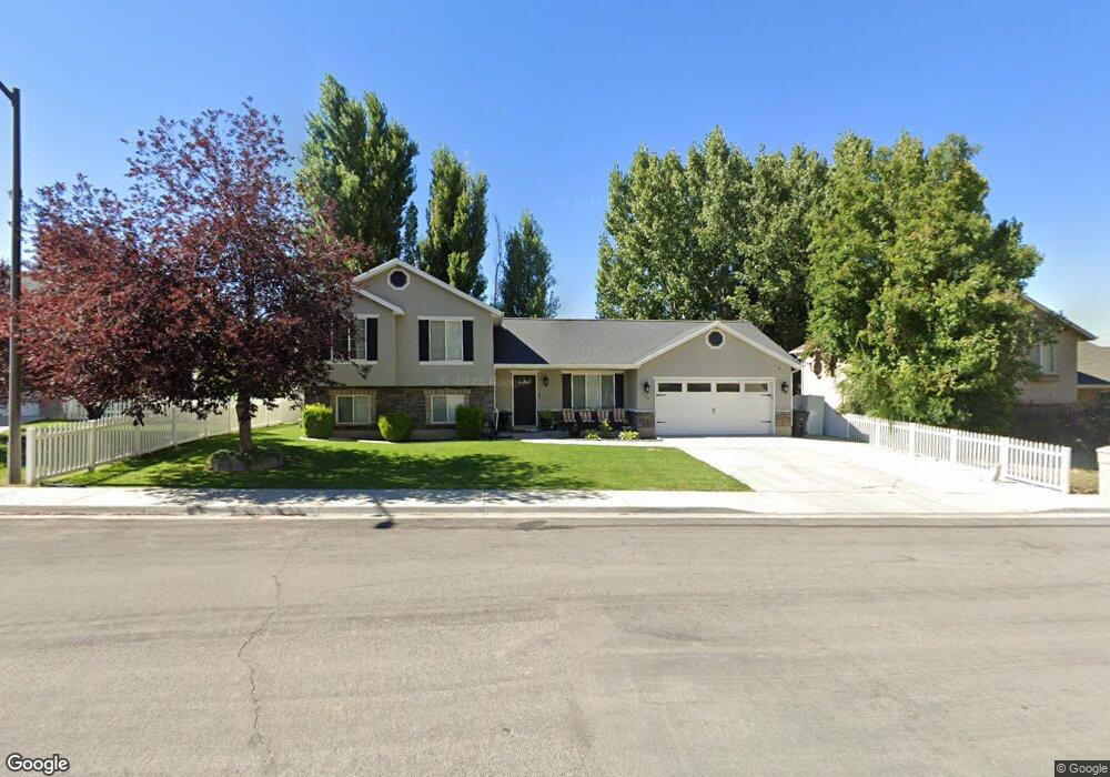
485 N 450 E Springville, UT 84663
Little Rock Canyon NeighborhoodEstimated Value: $447,000 - $469,982
3
Beds
2
Baths
1,103
Sq Ft
$419/Sq Ft
Est. Value
About This Home
This home is located at 485 N 450 E, Springville, UT 84663 and is currently estimated at $461,994, approximately $418 per square foot. 485 N 450 E is a home located in Utah County with nearby schools including Art City School, Springville Junior High School, and Springville High School.
Ownership History
Date
Name
Owned For
Owner Type
Purchase Details
Closed on
Jun 12, 2017
Sold by
Camberlango Stephanie A
Bought by
Camberlango Stephanie A
Current Estimated Value
Home Financials for this Owner
Home Financials are based on the most recent Mortgage that was taken out on this home.
Original Mortgage
$136,000
Outstanding Balance
$113,124
Interest Rate
4.02%
Mortgage Type
New Conventional
Estimated Equity
$348,870
Purchase Details
Closed on
Jan 23, 2015
Sold by
Benson Jason D
Bought by
Camberlango Stephanie A and Benson Stephanie A
Purchase Details
Closed on
Jul 26, 2012
Sold by
Benson Jason D and Benson Stephanie A
Bought by
Camberlango Stephanie A
Purchase Details
Closed on
Jun 29, 2011
Sold by
Benson Jason and Benson Stephanie
Bought by
Benson Jason D and Benson Stephanie A
Home Financials for this Owner
Home Financials are based on the most recent Mortgage that was taken out on this home.
Original Mortgage
$91,800
Interest Rate
4.55%
Mortgage Type
New Conventional
Purchase Details
Closed on
Sep 29, 2008
Sold by
Camberlango Brian and Camberlango Elizabeth
Bought by
Benson Jason and Benson Stephanie
Home Financials for this Owner
Home Financials are based on the most recent Mortgage that was taken out on this home.
Original Mortgage
$93,500
Interest Rate
6.43%
Mortgage Type
Purchase Money Mortgage
Purchase Details
Closed on
May 1, 2003
Sold by
Camberlango Brian and Camberlango Elizabeth
Bought by
Camberlango Brian and Camberlango Elizabeth
Home Financials for this Owner
Home Financials are based on the most recent Mortgage that was taken out on this home.
Original Mortgage
$99,500
Interest Rate
4.87%
Mortgage Type
Purchase Money Mortgage
Purchase Details
Closed on
Jun 20, 2001
Sold by
Cameros Development Llc
Bought by
Camberlango Brian and Camberlango Elizabeth
Home Financials for this Owner
Home Financials are based on the most recent Mortgage that was taken out on this home.
Original Mortgage
$113,600
Interest Rate
7.15%
Create a Home Valuation Report for This Property
The Home Valuation Report is an in-depth analysis detailing your home's value as well as a comparison with similar homes in the area
Home Values in the Area
Average Home Value in this Area
Purchase History
| Date | Buyer | Sale Price | Title Company |
|---|---|---|---|
| Camberlango Stephanie A | -- | Provo Land Title Co | |
| Camberlango Stephanie A | -- | First American Title | |
| Camberlango Stephanie A | -- | Provo Land Title Co | |
| Benson Jason D | -- | Provo Land Title Company | |
| Benson Jason | -- | Atlas Title | |
| Camberlango Brian | -- | Liberty Title | |
| Camberlango Brian | -- | First American Title Co |
Source: Public Records
Mortgage History
| Date | Status | Borrower | Loan Amount |
|---|---|---|---|
| Open | Camberlango Stephanie A | $136,000 | |
| Closed | Benson Jason D | $91,800 | |
| Closed | Benson Jason | $93,500 | |
| Previous Owner | Camberlango Brian | $99,500 | |
| Previous Owner | Camberlango Brian | $113,600 |
Source: Public Records
Tax History
| Year | Tax Paid | Tax Assessment Tax Assessment Total Assessment is a certain percentage of the fair market value that is determined by local assessors to be the total taxable value of land and additions on the property. | Land | Improvement |
|---|---|---|---|---|
| 2025 | $2,232 | $247,665 | -- | -- |
| 2024 | $2,232 | $228,690 | $0 | $0 |
| 2023 | $2,205 | $226,160 | $0 | $0 |
| 2022 | $2,258 | $227,425 | $0 | $0 |
| 2021 | $1,970 | $308,800 | $120,400 | $188,400 |
| 2020 | $1,866 | $283,600 | $100,300 | $183,300 |
| 2019 | $1,697 | $262,600 | $93,400 | $169,200 |
| 2018 | $1,566 | $231,100 | $83,000 | $148,100 |
| 2017 | $1,524 | $119,515 | $0 | $0 |
| 2016 | $1,407 | $108,185 | $0 | $0 |
| 2015 | $1,249 | $98,175 | $0 | $0 |
| 2014 | $1,228 | $95,865 | $0 | $0 |
Source: Public Records
Map
Nearby Homes
Your Personal Tour Guide
Ask me questions while you tour the home.