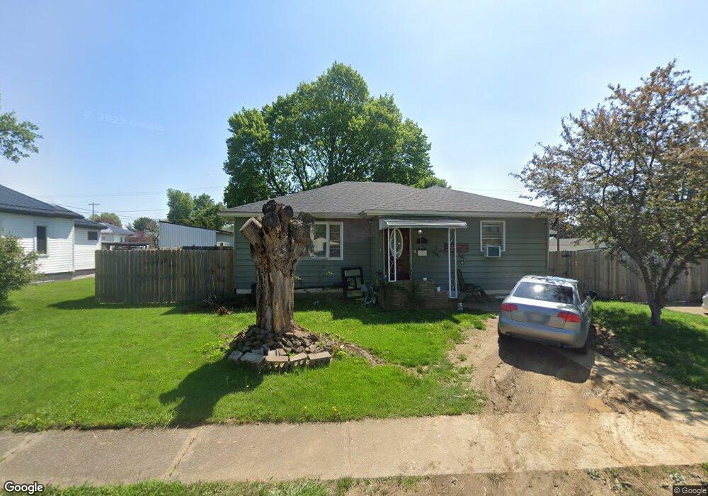
485 Spaulding Ave Newcomerstown, OH 43832
Estimated Value: $130,000 - $141,505
3
Beds
1
Bath
1,120
Sq Ft
$121/Sq Ft
Est. Value
About This Home
This home is located at 485 Spaulding Ave, Newcomerstown, OH 43832 and is currently estimated at $135,626, approximately $121 per square foot. 485 Spaulding Ave is a home located in Tuscarawas County with nearby schools including West Elementary School, East Elementary School, and Newcomerstown Middle School.
Ownership History
Date
Name
Owned For
Owner Type
Purchase Details
Closed on
May 9, 2003
Sold by
Rehard Dorothea E
Bought by
Bliss Amanda Sue
Current Estimated Value
Home Financials for this Owner
Home Financials are based on the most recent Mortgage that was taken out on this home.
Original Mortgage
$57,680
Outstanding Balance
$24,607
Interest Rate
6.02%
Mortgage Type
Purchase Money Mortgage
Estimated Equity
$111,019
Purchase Details
Closed on
Nov 9, 1988
Sold by
Rehard Willis E and Rehard Dorothea E
Bought by
Bliss Amanda Sue
Create a Home Valuation Report for This Property
The Home Valuation Report is an in-depth analysis detailing your home's value as well as a comparison with similar homes in the area
Home Values in the Area
Average Home Value in this Area
Purchase History
| Date | Buyer | Sale Price | Title Company |
|---|---|---|---|
| Bliss Amanda Sue | $72,100 | -- | |
| Bliss Amanda Sue | -- | -- |
Source: Public Records
Mortgage History
| Date | Status | Borrower | Loan Amount |
|---|---|---|---|
| Open | Bliss Amanda Sue | $57,680 |
Source: Public Records
Tax History
| Year | Tax Paid | Tax Assessment Tax Assessment Total Assessment is a certain percentage of the fair market value that is determined by local assessors to be the total taxable value of land and additions on the property. | Land | Improvement |
|---|---|---|---|---|
| 2024 | $1,202 | $93,210 | $15,340 | $77,870 |
| 2023 | $1,202 | $93,210 | $15,340 | $77,870 |
| 2022 | $1,146 | $32,624 | $5,369 | $27,255 |
| 2021 | $1,228 | $32,264 | $4,456 | $27,808 |
| 2020 | $1,243 | $32,264 | $4,456 | $27,808 |
| 2019 | $1,257 | $32,264 | $4,456 | $27,808 |
| 2018 | $1,100 | $27,230 | $3,760 | $23,470 |
| 2017 | $1,101 | $27,230 | $3,760 | $23,470 |
| 2016 | $1,103 | $27,230 | $3,760 | $23,470 |
| 2014 | $1,071 | $26,930 | $3,900 | $23,030 |
| 2013 | $1,080 | $26,930 | $3,900 | $23,030 |
Source: Public Records
Map
Nearby Homes
- 486 Mckinley Ave
- 453 Wood Ave
- 298 Mckinley Ave
- 241 Mckinley Ave
- 950 Beech St
- 508 Martin Luther King Dr
- 218 S Lawn Dr
- 234 N Bridge St
- 428 Chestnut St
- 376 E State St
- 346 N Bridge St
- 771 Cross St
- 60883 U S 36
- 782 E State St
- 555 E Canal St
- 14098 Washington Ave
- 60140 Everals Church Rd
- 5671 E State Rd
- 17805 Early Cemetary Rd
- 17437 Early Cemetary Rd SW
- 483 Spaulding Ave
- 495 Spaulding Ave
- 479 Spaulding Ave
- 492 Mckinley Ave
- 496 Mckinley Ave
- 497 Spaulding Ave
- 480 Mckinley Ave
- 477 Spaulding Ave
- 470 Spaulding Ave
- 472 Mckinley Ave
- 504 Mckinley Ave
- 468 Spaulding Ave
- 499 Spaulding Ave
- 468 Mckinley Ave
- 520 Mckinley Ave
- 461 Spaulding Ave
- 464 Spaulding Ave
- 462 Mckinley Ave
- 457 Tuscarawas Ave
- 483 Mckinley Ave
Your Personal Tour Guide
Ask me questions while you tour the home.