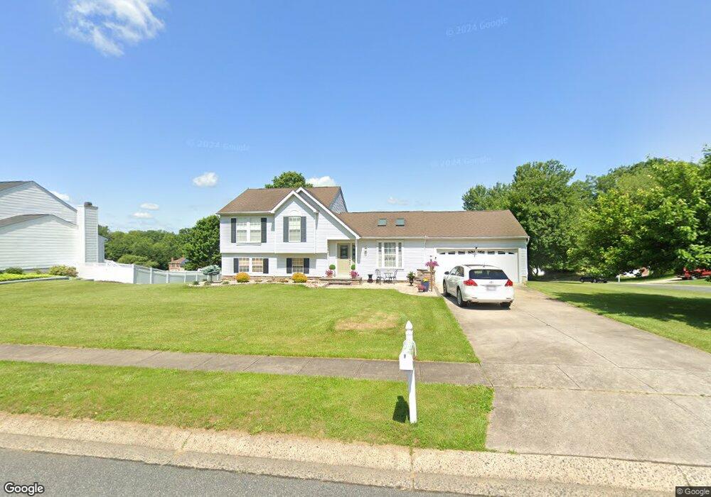
485 Windemere Dr Aberdeen, MD 21001
Estimated Value: $342,348 - $445,000
Studio
3
Baths
1,712
Sq Ft
$235/Sq Ft
Est. Value
About This Home
This home is located at 485 Windemere Dr, Aberdeen, MD 21001 and is currently estimated at $402,837, approximately $235 per square foot. 485 Windemere Dr is a home located in Harford County with nearby schools including Halls Cross Roads Elementary School, Aberdeen Middle School, and Aberdeen High School.
Ownership History
Date
Name
Owned For
Owner Type
Purchase Details
Closed on
Apr 12, 1990
Sold by
Ryland Group Inc The
Bought by
Jamison David A and Jamison Susan R
Current Estimated Value
Home Financials for this Owner
Home Financials are based on the most recent Mortgage that was taken out on this home.
Original Mortgage
$87,400
Interest Rate
10.26%
Purchase Details
Closed on
Jan 9, 1990
Sold by
Paradise Development Corporation
Bought by
Ryland Group Inc The
Create a Home Valuation Report for This Property
The Home Valuation Report is an in-depth analysis detailing your home's value as well as a comparison with similar homes in the area
Home Values in the Area
Average Home Value in this Area
Purchase History
| Date | Buyer | Sale Price | Title Company |
|---|---|---|---|
| Jamison David A | $132,700 | -- | |
| Ryland Group Inc The | $65,000 | -- |
Source: Public Records
Mortgage History
| Date | Status | Borrower | Loan Amount |
|---|---|---|---|
| Closed | Jamison David A | $87,400 |
Source: Public Records
Tax History
| Year | Tax Paid | Tax Assessment Tax Assessment Total Assessment is a certain percentage of the fair market value that is determined by local assessors to be the total taxable value of land and additions on the property. | Land | Improvement |
|---|---|---|---|---|
| 2025 | $2,034 | $281,133 | $0 | $0 |
| 2024 | $2,034 | $263,567 | $0 | $0 |
| 2023 | $1,931 | $246,000 | $78,200 | $167,800 |
| 2022 | $1,906 | $242,733 | $0 | $0 |
| 2021 | $3,811 | $239,467 | $0 | $0 |
| 2020 | $1,953 | $236,200 | $78,200 | $158,000 |
| 2019 | $2,336 | $232,233 | $0 | $0 |
| 2018 | $2,275 | $228,267 | $0 | $0 |
| 2017 | $2,236 | $224,300 | $0 | $0 |
| 2016 | -- | $224,300 | $0 | $0 |
| 2015 | $2,356 | $224,300 | $0 | $0 |
| 2014 | $2,356 | $226,700 | $0 | $0 |
Source: Public Records
Map
Nearby Homes
- 0 Paradise Rd
- 607 Northgate Rd
- 516 Beards Hill Rd
- 520 Beards Hill Rd
- 709 Paul Dr
- 479 Manor Rd
- 748 Everist Dr
- 624 Southgate Rd
- 3605 Hays Rd
- 642 Andrews Rd
- 3501 Garrett Ct
- 303 Graceford Dr
- 302 Graceford Dr
- 3 Locust St
- 749 Gilbert Rd
- 8 Chestnut St Unit 8
- 69 Baker St
- 760 Gilbert Rd
- 147 Bannister Ave
- 724 Aldora Dr
- 487 Windemere Dr
- 450 Grasmere Ln
- 484 Windemere Dr
- 452 Grasmere Ln
- 447 Grasmere Ln
- 489 Windemere Dr
- 486 Windemere Dr
- 454 Grasmere Ln
- 449 Grasmere Ln
- 451 Grasmere Ln
- 440 Grasmere Dr
- 488 Windemere Dr
- 491 Windemere Dr
- 453 Grasmere Ln
- 456 Grasmere Ln
- 438 Grasmere Dr
- 455 Grasmere Ln
- 401 Grayslake Way
- 490 Windemere Dr
- 403 Grayslake Way
Your Personal Tour Guide
Ask me questions while you tour the home.