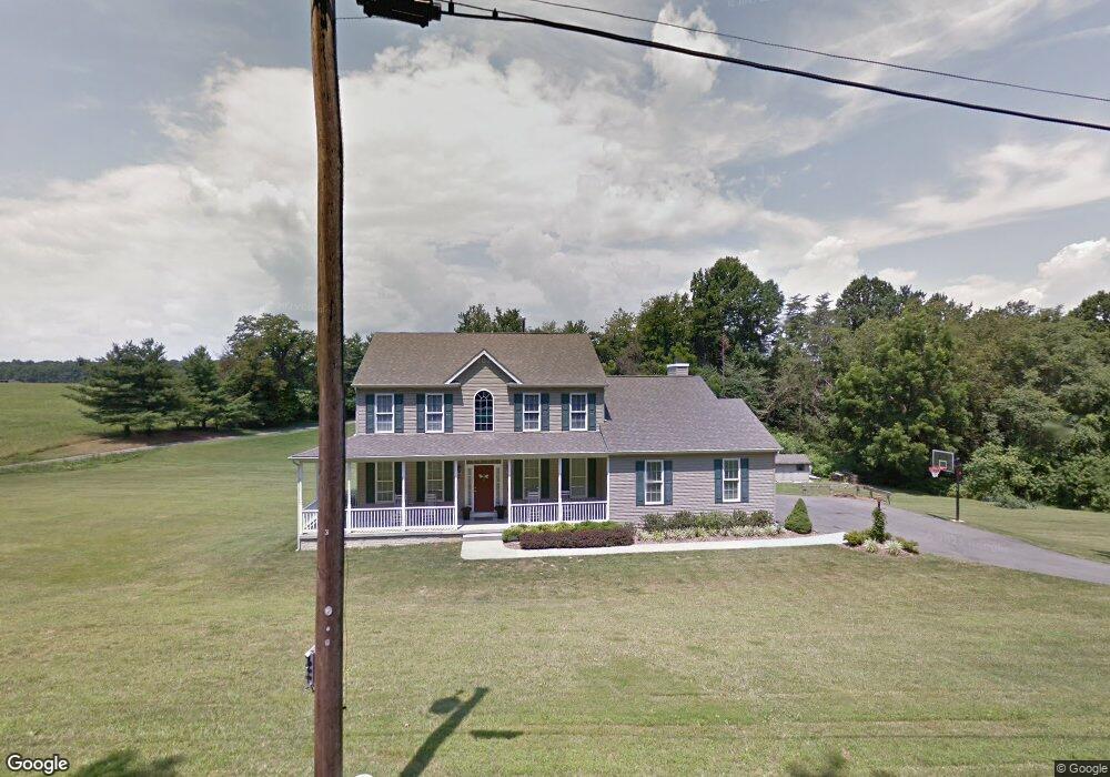
4850 Roop Rd Mount Airy, MD 21771
Estimated Value: $698,130 - $842,000
Studio
3
Baths
2,768
Sq Ft
$278/Sq Ft
Est. Value
About This Home
This home is located at 4850 Roop Rd, Mount Airy, MD 21771 and is currently estimated at $769,283, approximately $277 per square foot. 4850 Roop Rd is a home located in Carroll County with nearby schools including Winfield Elementary School, Mount Airy Middle School, and South Carroll High School.
Ownership History
Date
Name
Owned For
Owner Type
Purchase Details
Closed on
Jan 12, 2017
Sold by
Sturm Brian J
Bought by
Sturm Brian Joseph and Sturm Jennifer Scott
Current Estimated Value
Home Financials for this Owner
Home Financials are based on the most recent Mortgage that was taken out on this home.
Original Mortgage
$426,000
Outstanding Balance
$352,852
Interest Rate
4.3%
Mortgage Type
New Conventional
Estimated Equity
$416,431
Purchase Details
Closed on
Oct 31, 2011
Sold by
Sturm Brian J and Sturm Kelly D
Bought by
Sturm Brian J
Home Financials for this Owner
Home Financials are based on the most recent Mortgage that was taken out on this home.
Original Mortgage
$100,000
Interest Rate
4.01%
Mortgage Type
Credit Line Revolving
Purchase Details
Closed on
Sep 26, 2003
Sold by
Blaney James M
Bought by
Sturm Brian J and Sturm Kelly D
Create a Home Valuation Report for This Property
The Home Valuation Report is an in-depth analysis detailing your home's value as well as a comparison with similar homes in the area
Purchase History
| Date | Buyer | Sale Price | Title Company |
|---|---|---|---|
| Sturm Brian Joseph | -- | Sage Title Group Llc | |
| Sturm Brian J | -- | None Available | |
| Sturm Brian J | $160,000 | -- |
Source: Public Records
Mortgage History
| Date | Status | Borrower | Loan Amount |
|---|---|---|---|
| Open | Sturm Brian Joseph | $426,000 | |
| Closed | Sturm Brian J | $100,000 |
Source: Public Records
Tax History
| Year | Tax Paid | Tax Assessment Tax Assessment Total Assessment is a certain percentage of the fair market value that is determined by local assessors to be the total taxable value of land and additions on the property. | Land | Improvement |
|---|---|---|---|---|
| 2025 | $6,601 | $590,367 | $0 | $0 |
| 2024 | $6,282 | $555,600 | $189,700 | $365,900 |
| 2023 | $6,076 | $537,700 | $0 | $0 |
| 2022 | $5,881 | $519,800 | $0 | $0 |
| 2021 | $11,583 | $501,900 | $149,700 | $352,200 |
| 2020 | $5,669 | $496,400 | $0 | $0 |
| 2019 | $5,607 | $490,900 | $0 | $0 |
| 2018 | $5,496 | $485,400 | $149,700 | $335,700 |
| 2017 | $5,427 | $479,267 | $0 | $0 |
| 2016 | -- | $473,133 | $0 | $0 |
| 2015 | -- | $467,000 | $0 | $0 |
| 2014 | -- | $455,733 | $0 | $0 |
Source: Public Records
Map
Nearby Homes
- 4814 Ridge Rd
- 3222 Kimberly Dr
- 4525 Roop Rd
- 2507 Gillis Rd
- 4328 Ridge Rd Unit 13
- 4328 Ridge Rd Unit 14
- 2613 Liberty Rd
- 2514 W Liberty Rd
- 15539 Liberty Rd
- 0 Cabbage Spring Rd
- 4505 Gray Horse Dr
- 3895 Buffalo Rd
- 5730 Ridge Rd
- 3816 A Jim Smith Ln
- 3007 Merle Ct
- 6181 Challedon Cir
- 3410 Tuckaway Dr
- 6207 Belmont Cir
- 2900 Gillis Falls Rd
- 3174 Cardinal Dr
Your Personal Tour Guide
Ask me questions while you tour the home.