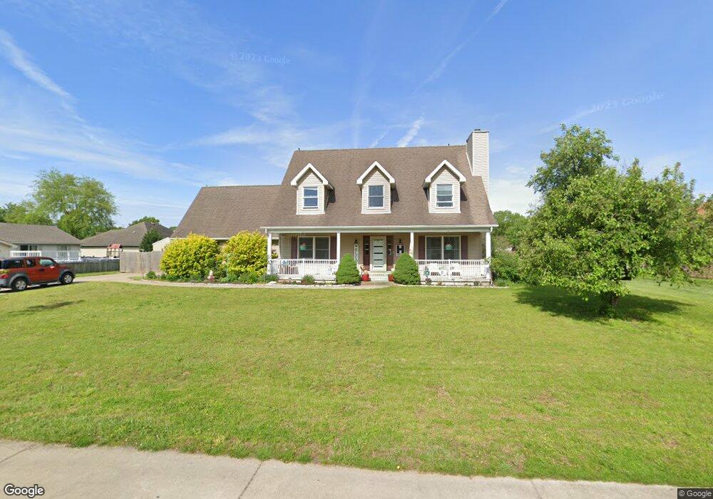
4851 S Path St Terre Haute, IN 47802
Estimated Value: $285,000 - $293,783
3
Beds
3
Baths
2,242
Sq Ft
$129/Sq Ft
Est. Value
About This Home
This home is located at 4851 S Path St, Terre Haute, IN 47802 and is currently estimated at $288,946, approximately $128 per square foot. 4851 S Path St is a home located in Vigo County with nearby schools including Blanche E. Fuqua Elementary School, Honey Creek Middle School, and Terre Haute South Vigo High School.
Ownership History
Date
Name
Owned For
Owner Type
Purchase Details
Closed on
Aug 6, 2021
Sold by
Fiscus Karla A
Bought by
Harris Ian
Current Estimated Value
Purchase Details
Closed on
Feb 28, 2017
Sold by
Kelty Shari L
Bought by
Fiscus Jason M and Fiscus Karla A
Home Financials for this Owner
Home Financials are based on the most recent Mortgage that was taken out on this home.
Original Mortgage
$161,405
Interest Rate
4.09%
Mortgage Type
New Conventional
Create a Home Valuation Report for This Property
The Home Valuation Report is an in-depth analysis detailing your home's value as well as a comparison with similar homes in the area
Home Values in the Area
Average Home Value in this Area
Purchase History
| Date | Buyer | Sale Price | Title Company |
|---|---|---|---|
| Harris Ian | $220,000 | Hendrich Title Company | |
| Fiscus Jason M | -- | None Available |
Source: Public Records
Mortgage History
| Date | Status | Borrower | Loan Amount |
|---|---|---|---|
| Previous Owner | Fiscus Jason M | $161,405 |
Source: Public Records
Tax History Compared to Growth
Tax History
| Year | Tax Paid | Tax Assessment Tax Assessment Total Assessment is a certain percentage of the fair market value that is determined by local assessors to be the total taxable value of land and additions on the property. | Land | Improvement |
|---|---|---|---|---|
| 2024 | $5,361 | $242,100 | $67,200 | $174,900 |
| 2023 | $5,155 | $232,500 | $67,200 | $165,300 |
| 2022 | $4,534 | $211,600 | $67,200 | $144,400 |
| 2021 | $2,172 | $198,500 | $65,900 | $132,600 |
| 2020 | $2,143 | $200,100 | $65,300 | $134,800 |
| 2019 | $2,135 | $199,700 | $64,100 | $135,600 |
| 2018 | $3,177 | $197,000 | $62,300 | $134,700 |
| 2017 | $2,615 | $207,100 | $73,100 | $134,000 |
| 2016 | $2,568 | $204,600 | $71,700 | $132,900 |
| 2014 | $2,021 | $196,200 | $68,800 | $127,400 |
| 2013 | $2,021 | $195,700 | $68,100 | $127,600 |
Source: Public Records
Map
Nearby Homes
- 4741 S 19th 1 2 St
- 4855 S Lost St
- 4412 S 12th St
- 1012 Windsor Rd
- 44 Allendale
- 4315 S 12th St
- 901 E Talisman Dr
- 852 E Talisman Dr
- 3330 Albany Rd
- 5000 Block S Us Hwy 41
- 809 E Azalia Dr
- 4715 S 7th St
- 61 S Jeane St
- 1159 S Ravine St
- 226 Highland Ct
- 5609 Bison Ln
- 60 E Longridge Rd
- 5614 Bison Ln
- 3325 Rabbit Run Ct
- 411 Edgemoor Rd
- 4825 S Path St
- 4870 S Path St
- 4852 S Path St
- 2088 Channel Ct
- 4820 S Path St
- 2052 Channel Ct
- 4779 S Path St
- 4888 S Path St
- 4776 S Path St
- 4823 S Lock St
- 2083 Channel Ct
- 4865 S Lock St
- 4857 S Lock St
- 4930 S Path St
- 4781 S Lock St Unit LT30
- 2055 Channel Ct
- 2026 Channel Ct
- 4879 S Lock St
- 4755 S Path St
- 4759 S Lock St