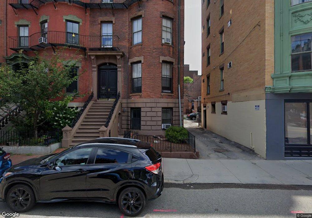
486 Massachusetts Ave Boston, MA 02118
South End NeighborhoodEstimated Value: $3,259,000 - $4,754,000
11
Beds
3
Baths
5,078
Sq Ft
$789/Sq Ft
Est. Value
About This Home
This home is located at 486 Massachusetts Ave, Boston, MA 02118 and is currently estimated at $4,006,500, approximately $788 per square foot. 486 Massachusetts Ave is a home located in Suffolk County with nearby schools including Edward M. Kennedy Academy for Health Careers and Cathedral High School.
Ownership History
Date
Name
Owned For
Owner Type
Purchase Details
Closed on
Jun 15, 1993
Sold by
Degiacomo James R
Bought by
Mill Pond Rt and Siegel David
Current Estimated Value
Create a Home Valuation Report for This Property
The Home Valuation Report is an in-depth analysis detailing your home's value as well as a comparison with similar homes in the area
Home Values in the Area
Average Home Value in this Area
Purchase History
| Date | Buyer | Sale Price | Title Company |
|---|---|---|---|
| Mill Pond Rt | $60,000 | -- |
Source: Public Records
Mortgage History
| Date | Status | Borrower | Loan Amount |
|---|---|---|---|
| Open | Mill Pond Rt | $239,628 | |
| Closed | Mill Pond Rt | $235,550 |
Source: Public Records
Tax History Compared to Growth
Tax History
| Year | Tax Paid | Tax Assessment Tax Assessment Total Assessment is a certain percentage of the fair market value that is determined by local assessors to be the total taxable value of land and additions on the property. | Land | Improvement |
|---|---|---|---|---|
| 2025 | $53,009 | $4,577,600 | $1,565,100 | $3,012,500 |
| 2024 | $44,173 | $4,052,600 | $913,300 | $3,139,300 |
| 2023 | $43,525 | $4,052,600 | $913,300 | $3,139,300 |
| 2022 | $44,092 | $4,052,600 | $913,300 | $3,139,300 |
| 2021 | $41,981 | $3,934,500 | $886,700 | $3,047,800 |
| 2020 | $38,673 | $3,662,200 | $978,800 | $2,683,400 |
| 2019 | $35,084 | $3,328,700 | $706,700 | $2,622,000 |
| 2018 | $32,591 | $3,109,800 | $706,700 | $2,403,100 |
| 2017 | $30,498 | $2,879,900 | $706,700 | $2,173,200 |
| 2016 | $29,069 | $2,642,600 | $706,700 | $1,935,900 |
| 2015 | $28,985 | $2,393,500 | $501,600 | $1,891,900 |
| 2014 | $26,171 | $2,080,400 | $501,600 | $1,578,800 |
Source: Public Records
Map
Nearby Homes
- 193 W Springfield St
- 203 W Springfield St Unit 1
- 202 W Springfield St Unit 3
- 211 W Springfield St
- 771 Tremont St Unit 2
- 492 Massachusetts Ave Unit 53
- 144 Worcester St Unit 1
- 144 Worcester St Unit 3
- 221 W Springfield St Unit 3
- 460 Massachusetts Ave Unit B
- 8 Concord Square Unit 1
- 12 Concord Square Unit 1
- 483 Massachusetts Ave Unit 7
- 491 Massachusetts Ave Unit 1
- 30 Concord Square Unit 1
- 88 Worcester St Unit 4
- 451-453 Massachusetts Ave Unit 8
- 530 Massachusetts Ave Unit 2
- 15 Concord Square Unit 1A
- 82 Worcester St Unit 2
- 486 Massachusetts Ave Unit 3
- 486 Massachusetts Ave Unit 1
- 486 Massachusetts Ave
- 486 Massachusetts Ave Unit 2
- 484 Massachusetts Ave Unit 4
- 484 Massachusetts Ave Unit 3
- 484 Massachusetts Ave Unit 2
- 484 Massachusetts Ave Unit 1
- 482 Mass Ave Unit 3
- 482 Massachusetts Ave Unit 3
- 482 Massachusetts Ave Unit 1
- 482 Massachusetts Ave Unit 4
- 482 Massachusetts Ave Unit 5
- 482 Massachusetts Ave Unit 2
- 482 Massachusetts Ave
- 492 Massachusetts Ave Unit 73
- 492 Massachusetts Ave Unit 72
- 492 Massachusetts Ave Unit 71
- 492 Massachusetts Ave Unit 63
- 492 Massachusetts Ave Unit 62