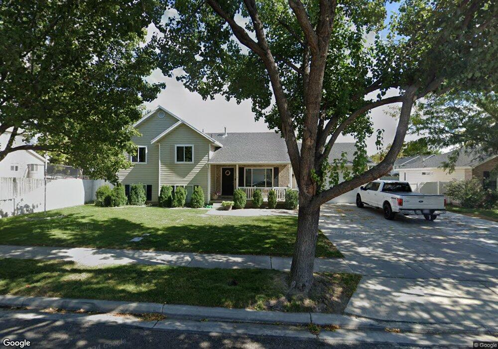
486 N 650 W American Fork, UT 84003
Estimated Value: $537,578 - $566,000
4
Beds
3
Baths
1,967
Sq Ft
$282/Sq Ft
Est. Value
About This Home
This home is located at 486 N 650 W, American Fork, UT 84003 and is currently estimated at $555,645, approximately $282 per square foot. 486 N 650 W is a home located in Utah County with nearby schools including Shelley Elementary School, American Fork Junior High School, and American Fork High School.
Ownership History
Date
Name
Owned For
Owner Type
Purchase Details
Closed on
Aug 7, 2020
Sold by
Shumway Jordan and Shumway Sydnee A
Bought by
Shumway Jordan Bruce and Shumway Sydnee Ann
Current Estimated Value
Home Financials for this Owner
Home Financials are based on the most recent Mortgage that was taken out on this home.
Original Mortgage
$181,000
Outstanding Balance
$128,521
Interest Rate
3%
Mortgage Type
New Conventional
Estimated Equity
$427,124
Purchase Details
Closed on
Mar 14, 2014
Sold by
Hohmann Michael and Hohmann Rachael
Bought by
Shumway Jordan and Shumway Sydnee A
Home Financials for this Owner
Home Financials are based on the most recent Mortgage that was taken out on this home.
Original Mortgage
$189,900
Interest Rate
4.29%
Mortgage Type
New Conventional
Purchase Details
Closed on
Nov 30, 2005
Sold by
Cendant Mobility Financial Corp
Bought by
Hohmann Michael and Hohmann Rachael
Home Financials for this Owner
Home Financials are based on the most recent Mortgage that was taken out on this home.
Original Mortgage
$160,000
Interest Rate
6.75%
Mortgage Type
New Conventional
Purchase Details
Closed on
Nov 22, 2005
Sold by
Webb Phil and Webb Susie
Bought by
Cendant Mobility Financial Corp
Home Financials for this Owner
Home Financials are based on the most recent Mortgage that was taken out on this home.
Original Mortgage
$160,000
Interest Rate
6.75%
Mortgage Type
New Conventional
Purchase Details
Closed on
Oct 16, 2002
Sold by
Webb Phil
Bought by
Webb Phil and Webb Susie
Home Financials for this Owner
Home Financials are based on the most recent Mortgage that was taken out on this home.
Original Mortgage
$140,000
Interest Rate
6.05%
Purchase Details
Closed on
Jul 29, 1996
Sold by
Demar Construction Inc
Bought by
Webb Phil and Webb Susie
Home Financials for this Owner
Home Financials are based on the most recent Mortgage that was taken out on this home.
Original Mortgage
$128,850
Interest Rate
8.39%
Create a Home Valuation Report for This Property
The Home Valuation Report is an in-depth analysis detailing your home's value as well as a comparison with similar homes in the area
Home Values in the Area
Average Home Value in this Area
Purchase History
| Date | Buyer | Sale Price | Title Company |
|---|---|---|---|
| Shumway Jordan Bruce | -- | Stewart Ttl Ins Agcy Of Uta | |
| Shumway Jordan | -- | Access Title Co | |
| Hohmann Michael | -- | Utah Standard Title | |
| Cendant Mobility Financial Corp | -- | Utah Standard Title | |
| Webb Phil | -- | -- | |
| Webb Phil | -- | Guardian Title Insurance Ag | |
| Webb Phil | -- | -- |
Source: Public Records
Mortgage History
| Date | Status | Borrower | Loan Amount |
|---|---|---|---|
| Open | Shumway Jordan Bruce | $181,000 | |
| Closed | Shumway Jordan | $189,900 | |
| Previous Owner | Hohmann Michael | $160,000 | |
| Previous Owner | Cendant Mobility Financial Corp | $30,000 | |
| Previous Owner | Webb Phil | $140,000 | |
| Previous Owner | Webb Phil | $128,850 |
Source: Public Records
Tax History Compared to Growth
Tax History
| Year | Tax Paid | Tax Assessment Tax Assessment Total Assessment is a certain percentage of the fair market value that is determined by local assessors to be the total taxable value of land and additions on the property. | Land | Improvement |
|---|---|---|---|---|
| 2025 | $2,321 | $275,880 | $214,100 | $287,500 |
| 2024 | $2,321 | $257,895 | $0 | $0 |
| 2023 | $2,200 | $259,215 | $0 | $0 |
| 2022 | $2,399 | $278,905 | $0 | $0 |
| 2021 | $2,055 | $373,200 | $153,600 | $219,600 |
| 2020 | $1,923 | $338,600 | $137,100 | $201,500 |
| 2019 | $1,693 | $308,300 | $126,900 | $181,400 |
| 2018 | $1,608 | $280,100 | $120,000 | $160,100 |
| 2017 | $1,520 | $142,890 | $0 | $0 |
| 2016 | $1,510 | $131,890 | $0 | $0 |
| 2015 | $1,473 | $122,045 | $0 | $0 |
| 2014 | $1,438 | $117,590 | $0 | $0 |
Source: Public Records
Map
Nearby Homes
- 777 W State Rd
- 356 N 480 W
- 641 N 420 W
- 962 N 780 St W Unit 508
- 974 N 780 St W Unit 509
- 916 N 780 St W Unit 501
- 540 N 300 W
- 822 W 800 St N Unit LOT319
- 399 W Pacific Dr
- 602 W 860 N
- 822 N 860 W Unit 317
- 370 W Pacific Dr Unit 1
- 914 N 400 W Unit A
- 120 N 350 W Unit 127
- 120 N 350 W Unit 133
- 120 N 350 W Unit 130
- 3889 W 950 Cir N Unit 366
- 901 N Lakota Rd
- 987 N 410 W
- 782 N 200 W