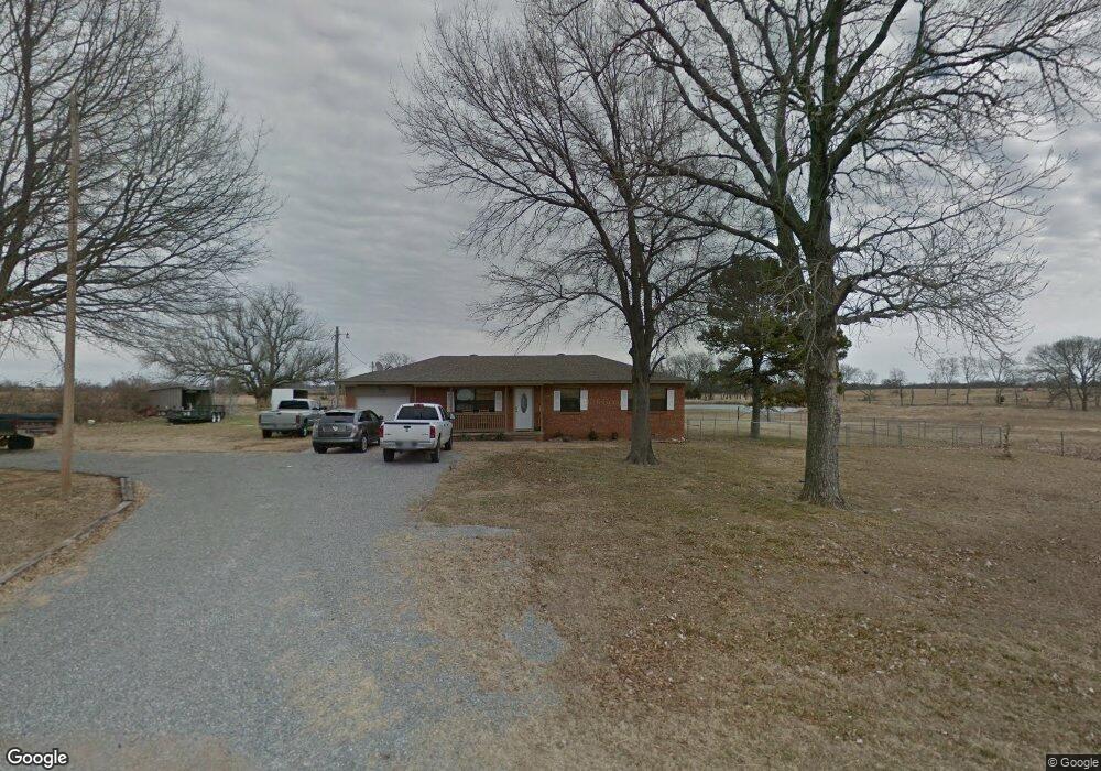
486 N Roberta Rd Durant, OK 74701
Estimated Value: $163,289 - $289,000
3
Beds
1
Bath
1,421
Sq Ft
$170/Sq Ft
Est. Value
About This Home
This home is located at 486 N Roberta Rd, Durant, OK 74701 and is currently estimated at $241,072, approximately $169 per square foot. 486 N Roberta Rd is a home located in Bryan County with nearby schools including Rock Creek Elementary School and Rock Creek High School.
Ownership History
Date
Name
Owned For
Owner Type
Purchase Details
Closed on
Aug 18, 2008
Sold by
Hall Gary and Hall Phyllis
Bought by
Demaree Rex W and Demaree Annmarie
Current Estimated Value
Home Financials for this Owner
Home Financials are based on the most recent Mortgage that was taken out on this home.
Original Mortgage
$147,784
Outstanding Balance
$96,398
Interest Rate
6.29%
Mortgage Type
FHA
Estimated Equity
$144,674
Purchase Details
Closed on
Jan 8, 2002
Sold by
Riley Roy and Riley Sheila K
Bought by
Harrington Joey and Harrington Sheila
Purchase Details
Closed on
May 4, 2000
Sold by
Case David M and Case Amy E
Bought by
Riley Roy D and Riley Sheila K
Purchase Details
Closed on
Oct 12, 1995
Sold by
Booze William C and Booze Sue
Bought by
Case David M and Case Amy E
Create a Home Valuation Report for This Property
The Home Valuation Report is an in-depth analysis detailing your home's value as well as a comparison with similar homes in the area
Purchase History
| Date | Buyer | Sale Price | Title Company |
|---|---|---|---|
| Demaree Rex W | $149,000 | None Available | |
| Harrington Joey | $80,000 | -- | |
| Riley Roy D | $67,000 | -- | |
| Case David M | $57,000 | -- |
Source: Public Records
Mortgage History
| Date | Status | Borrower | Loan Amount |
|---|---|---|---|
| Open | Demaree Rex W | $147,784 |
Source: Public Records
Tax History
| Year | Tax Paid | Tax Assessment Tax Assessment Total Assessment is a certain percentage of the fair market value that is determined by local assessors to be the total taxable value of land and additions on the property. | Land | Improvement |
|---|---|---|---|---|
| 2025 | $710 | $9,064 | $2,097 | $6,967 |
| 2024 | $658 | $8,800 | $2,036 | $6,764 |
| 2023 | $658 | $8,545 | $1,883 | $6,662 |
| 2022 | $612 | $8,296 | $1,691 | $6,605 |
| 2021 | $613 | $8,327 | $1,691 | $6,636 |
| 2020 | $596 | $8,085 | $1,691 | $6,394 |
| 2019 | $610 | $7,849 | $1,691 | $6,158 |
| 2018 | $595 | $7,621 | $1,691 | $5,930 |
| 2017 | $595 | $7,579 | $1,423 | $6,156 |
| 2016 | $580 | $7,358 | $399 | $6,959 |
| 2015 | $542 | $7,358 | $399 | $6,959 |
| 2014 | $542 | $7,358 | $399 | $6,959 |
Source: Public Records
Map
Nearby Homes
- 6322 State Road 70 E
- 7810 State Road 70 E
- 0 N A Unit 1211811
- 157 Ruby Lee
- 0003 One Well Rd
- 5224 State Road 70e
- 1978 E Davis Rd
- 933 One Well Rd
- 2837 Haworth Rd
- 0 Cypress
- 0 S Lone Oak Rd Unit 2547145
- 0 S Lone Oak Rd Unit 2547144
- 0 S Lone Oak Rd Unit 2547139
- 0 N Philadelphia Rd
- 001 N Philadelphia Rd
- 22786 State Road 78
- 1163 N3780 Rd
- 1895 Old Highway 70
- 798 S Lone Oak Rd
- 21600 State Road 78
- 517 N Roberta Rd
- 712 N Roberta Rd
- 292 N Roberta Rd
- 224 N Roberta Rd
- 190 N Roberta Rd
- 805 N Roberta Rd
- 28 W Ward Rd
- 80 W Ward Rd
- 87 W Ward Rd
- 35 W Ward Rd
- 79 N Roberta Rd
- 271 Wolf Creek Cemetery Rd
- 88 N Roberta Rd
- 7069 State Road 70 E
- 7321 State Road 70 E
- 7249 State Road 70 E
- 3676 E Davis Rd
- 3676 E Davis Rd
- 3715 E Davis Rd
- 501 Ethel Ln
Your Personal Tour Guide
Ask me questions while you tour the home.