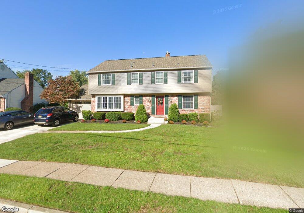
486 Westwood Dr West Deptford, NJ 08096
West Deptford Township NeighborhoodEstimated Value: $463,998 - $513,000
--
Bed
--
Bath
2,188
Sq Ft
$224/Sq Ft
Est. Value
About This Home
This home is located at 486 Westwood Dr, West Deptford, NJ 08096 and is currently estimated at $490,750, approximately $224 per square foot. 486 Westwood Dr is a home located in Gloucester County with nearby schools including Green-Fields Elementary School, Oakview Elementary School, and Red Bank Elementary School.
Ownership History
Date
Name
Owned For
Owner Type
Purchase Details
Closed on
Sep 6, 1988
Bought by
Hink James M and Hink Karen S
Current Estimated Value
Create a Home Valuation Report for This Property
The Home Valuation Report is an in-depth analysis detailing your home's value as well as a comparison with similar homes in the area
Home Values in the Area
Average Home Value in this Area
Purchase History
| Date | Buyer | Sale Price | Title Company |
|---|---|---|---|
| Hink James M | $142,000 | -- |
Source: Public Records
Tax History Compared to Growth
Tax History
| Year | Tax Paid | Tax Assessment Tax Assessment Total Assessment is a certain percentage of the fair market value that is determined by local assessors to be the total taxable value of land and additions on the property. | Land | Improvement |
|---|---|---|---|---|
| 2025 | $10,539 | $301,800 | $87,900 | $213,900 |
| 2024 | $10,403 | $301,800 | $87,900 | $213,900 |
| 2023 | $10,403 | $301,800 | $87,900 | $213,900 |
| 2022 | $10,355 | $301,800 | $87,900 | $213,900 |
| 2021 | $10,319 | $301,800 | $87,900 | $213,900 |
| 2020 | $10,294 | $301,800 | $87,900 | $213,900 |
| 2019 | $10,008 | $301,800 | $87,900 | $213,900 |
| 2018 | $9,736 | $301,800 | $87,900 | $213,900 |
| 2017 | $9,091 | $301,800 | $87,900 | $213,900 |
| 2016 | $8,837 | $301,800 | $87,900 | $213,900 |
| 2015 | $8,418 | $301,800 | $87,900 | $213,900 |
| 2014 | $8,000 | $285,600 | $87,900 | $197,700 |
Source: Public Records
Map
Nearby Homes
- 1102 Barnesdale Rd
- 4 Saint Emilion Ct
- 1311 Barnesdale Rd
- 1220 Royal Ln
- 1810 Fernwood Dr
- 87 Woodway Dr Unit 87
- 863 Doncaster Dr
- 740 Carter Hill Dr
- 16 Maplewood Ct
- 558 Prince St
- 640 Worcester Dr
- 12 Highbridge Ln Unit I2
- 125 Lionheart Ln Unit C125
- 344 S Girard St
- 438 S Columbia St
- 608 Salem Ave
- 1012 Moore Rd Unit 6
- 1066 Buckingham Dr
- 1091 Buckingham Dr Unit 45
- 64 Tilden Rd
- 490 Westwood Dr
- 482 Westwood Dr
- 481 Westwood Dr
- 478 Westwood Dr
- 388 Nottingham Rd
- 477 Westwood Dr
- 384 Nottingham Rd
- 392 Nottingham Rd
- 474 Westwood Dr
- 1302 Barnesdale Rd
- 380 Nottingham Rd
- 473 Westwood Dr
- 1304 Barnesdale Rd
- 1063 Barnesdale Rd
- 470 Westwood Dr
- 1111 Barnesdale Rd
- 1103 Barnesdale Rd
- 1119 Barnesdale Rd
- 376 Nottingham Rd
- 1306 Barnesdale Rd