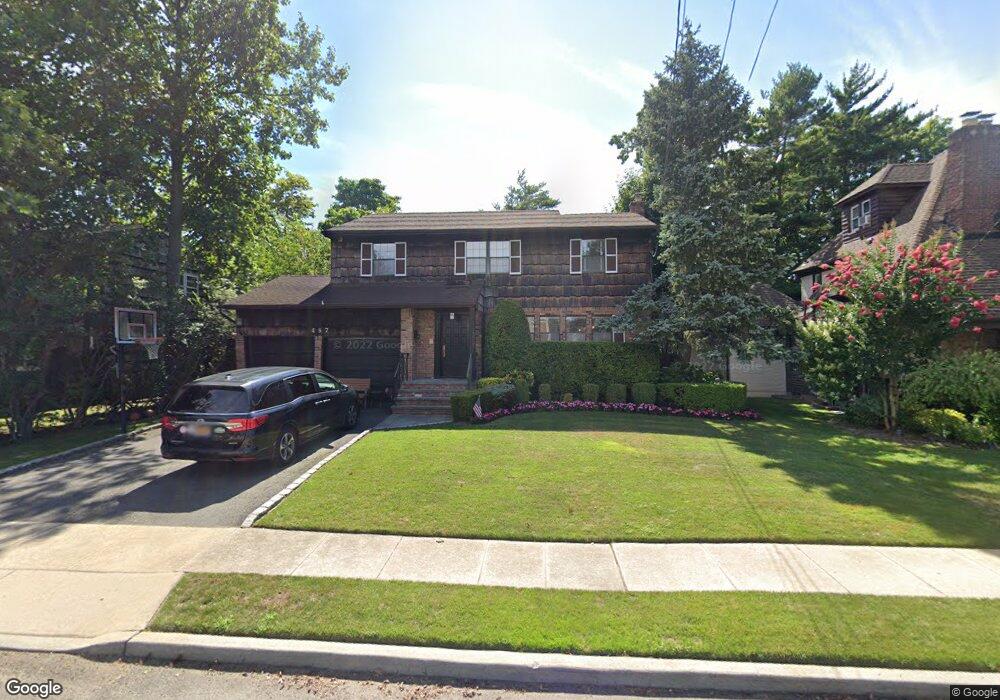
487 Barnard Ave Cedarhurst, NY 11516
Estimated Value: $1,148,773 - $1,554,000
--
Bed
3
Baths
1,996
Sq Ft
$677/Sq Ft
Est. Value
About This Home
This home is located at 487 Barnard Ave, Cedarhurst, NY 11516 and is currently estimated at $1,351,387, approximately $677 per square foot. 487 Barnard Ave is a home located in Nassau County with nearby schools including Lawrence Primary School, Lawrence Elementary School, and Lawrence Middle School.
Ownership History
Date
Name
Owned For
Owner Type
Purchase Details
Closed on
May 10, 2012
Sold by
Weiss Shlomo Z and Weiss Beth
Bought by
Knoll Eli and Knoll Sarah
Current Estimated Value
Home Financials for this Owner
Home Financials are based on the most recent Mortgage that was taken out on this home.
Original Mortgage
$405,000
Outstanding Balance
$282,048
Interest Rate
4.01%
Estimated Equity
$1,069,339
Purchase Details
Closed on
Jul 3, 2001
Sold by
Leibowitz Harvey
Bought by
Weiss Shlomo Z Beth
Create a Home Valuation Report for This Property
The Home Valuation Report is an in-depth analysis detailing your home's value as well as a comparison with similar homes in the area
Home Values in the Area
Average Home Value in this Area
Purchase History
| Date | Buyer | Sale Price | Title Company |
|---|---|---|---|
| Knoll Eli | $755,000 | Sutton Land Title Agency | |
| Weiss Shlomo Z Beth | $450,000 | Lawrence Schreier |
Source: Public Records
Mortgage History
| Date | Status | Borrower | Loan Amount |
|---|---|---|---|
| Open | Knoll Eli | $405,000 |
Source: Public Records
Tax History Compared to Growth
Tax History
| Year | Tax Paid | Tax Assessment Tax Assessment Total Assessment is a certain percentage of the fair market value that is determined by local assessors to be the total taxable value of land and additions on the property. | Land | Improvement |
|---|---|---|---|---|
| 2025 | $9,536 | $710 | $261 | $449 |
| 2024 | $3,225 | $700 | $258 | $442 |
| 2023 | $8,580 | $746 | $275 | $471 |
| 2022 | $8,580 | $763 | $281 | $482 |
| 2021 | $11,195 | $816 | $273 | $543 |
| 2020 | $9,173 | $1,042 | $705 | $337 |
| 2019 | $9,894 | $1,061 | $718 | $343 |
| 2018 | $9,639 | $1,061 | $0 | $0 |
| 2017 | $5,972 | $1,107 | $718 | $389 |
| 2016 | $9,171 | $1,107 | $718 | $389 |
| 2015 | $2,976 | $1,107 | $718 | $389 |
| 2014 | $2,976 | $1,107 | $718 | $389 |
| 2013 | $2,746 | $1,107 | $718 | $389 |
Source: Public Records
Map
Nearby Homes
- 410 Church Ave
- 508 Monroe St
- 313 Forest Ave
- 7 Park Cir
- 439 Bayview Ave
- 25 Park Cir
- 544 Arlington Rd
- 383 Clinton Ave
- 276 Cedarhurst Ave Unit B2
- 276 Cedarhurst Ave Unit B4
- 467 W Broadway
- 272 Cedarhurst Ave Unit A6
- 536 Albemarle Rd
- 761 W Broadway
- 291 Cedarhurst Ave Unit K9
- 279 Cedarhurst Ave Unit G-6
- 559 Arlington Place
- 504 Cedarwood Dr
- 461 5th Ave
- 487 Court Ave
- 477 Barnard Ave
- 488 Arbuckle Ave
- 490 Arbuckle Ave
- 484 Arbuckle Ave
- 467 Barnard Ave
- 348 Barnard Ave
- 357 Barnard Ave
- 480 Arbuckle Ave
- 352 Barnard Ave
- 496 Arbuckle Ave
- 474 Barnard Ave
- 351 Barnard Ave
- 358 Barnard Ave
- 465 Barnard Ave
- 587 - 589 Central Ave
- 545 Cental Ave Unit 36A
- 699 Psrk Hwy
- 510 Arbuckle Ave
- 365 Barnard Ave
- 347 Church Ave