Estimated Value: $255,000 - $304,000
4
Beds
3
Baths
2,268
Sq Ft
$123/Sq Ft
Est. Value
About This Home
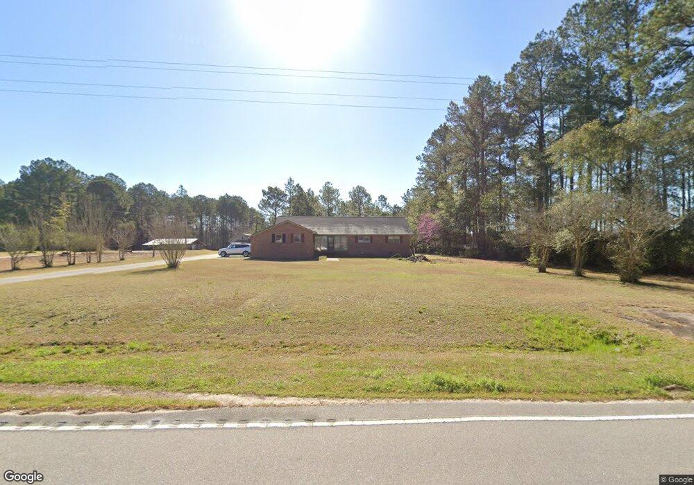
This home is located at 4875 Cannon Bridge Rd, Cope, SC 29038 and is currently estimated at $278,600, approximately $122 per square foot. 4875 Cannon Bridge Rd is a home located in Orangeburg County with nearby schools including Edisto Primary, Edisto Elementary, and Carver Edisto Middle School.
Ownership History
Date
Name
Owned For
Owner Type
Purchase Details
Closed on
Dec 5, 2019
Sold by
Breland Odell and Breland Anna G
Bought by
Brown Michael W and Brown Savannah S
Current Estimated Value
Home Financials for this Owner
Home Financials are based on the most recent Mortgage that was taken out on this home.
Original Mortgage
$152,192
Outstanding Balance
$133,566
Interest Rate
3.37%
Mortgage Type
FHA
Estimated Equity
$145,034
Purchase Details
Closed on
Dec 2, 2019
Sold by
Breland Roger Dennis
Bought by
Breland Odell and Breland Anna G
Home Financials for this Owner
Home Financials are based on the most recent Mortgage that was taken out on this home.
Original Mortgage
$152,192
Outstanding Balance
$133,566
Interest Rate
3.37%
Mortgage Type
FHA
Estimated Equity
$145,034
Purchase Details
Closed on
Jun 15, 2017
Sold by
Breland Odell
Bought by
Smoak Dianne B and Breland Stanley Robert
Create a Home Valuation Report for This Property
The Home Valuation Report is an in-depth analysis detailing your home's value as well as a comparison with similar homes in the area
Purchase History
| Date | Buyer | Sale Price | Title Company |
|---|---|---|---|
| Brown Michael W | $155,000 | None Available | |
| Breland Odell | -- | None Available | |
| Breland Odell | -- | None Available | |
| Breland Odell | -- | None Available | |
| Breland Odell | -- | None Available | |
| Smoak Dianne B | -- | None Available |
Source: Public Records
Mortgage History
| Date | Status | Borrower | Loan Amount |
|---|---|---|---|
| Open | Brown Michael W | $152,192 |
Source: Public Records
Tax History
| Year | Tax Paid | Tax Assessment Tax Assessment Total Assessment is a certain percentage of the fair market value that is determined by local assessors to be the total taxable value of land and additions on the property. | Land | Improvement |
|---|---|---|---|---|
| 2024 | $1,352 | $7,030 | $244 | $6,786 |
| 2023 | $1,196 | $6,115 | $239 | $5,876 |
| 2022 | $1,166 | $6,115 | $239 | $5,876 |
| 2021 | $1,147 | $6,115 | $239 | $5,876 |
| 2020 | $3,437 | $6,115 | $239 | $5,876 |
| 2019 | $649 | $8,272 | $0 | $0 |
| 2018 | $736 | $5,799 | $239 | $5,560 |
| 2017 | $729 | $5,799 | $0 | $0 |
| 2016 | $728 | $5,799 | $0 | $0 |
| 2015 | $671 | $5,799 | $0 | $0 |
| 2014 | $671 | $5,799 | $239 | $5,560 |
| 2013 | -- | $6,211 | $239 | $5,972 |
Source: Public Records
Map
Nearby Homes
- 4857 Cannon Bridge Rd
- 1510 Hudson Rd
- 133 Banning St
- 0 River Vista Dr & Farr Rd
- 1 Stevenson Rd
- 220 Ivory St
- 0 Blewer
- 0 Carver School Rd Unit 24022381
- 4446 Char-Augusta Rd
- 00 Ryn St
- 92 Alex Ln
- 0 Loblolly Ct Unit 25013082
- 0 Loblolly Ct Unit 169810
- 48 Loblolly Ct
- 105 River Birch Rd
- 32 Cockadoodle Loop
- 216 Sumter St
- 000 Slab Landing Rd
- 15 Marta St
- 3661 Faust St
- 4857 Cannon Bridge Rd
- 4857 Cannon Bridge Rd
- 4931 Cannon Bridge Rd
- 4977 Cannon Bridge Rd
- 4851 Cannon Bridge Rd
- 4982 Cannon Bridge Rd
- 4983 Cannon Bridge Rd
- 1749 Hudson Rd
- 1580 Hudson Rd
- 5007 Cannon Bridge Rd
- 1772 Hudson Rd
- 4762 Cannon Bridge Rd
- 258 Saw Tooth Trail
- 0000 Cannon Bridge Rd
- 1521 Hudson Rd
- 1840 Hudson Rd
- 1819 Hudson Rd
- 5028 Cannon Bridge Rd
- 1518 Hudson Rd
- 1491 Hudson Rd
Your Personal Tour Guide
Ask me questions while you tour the home.