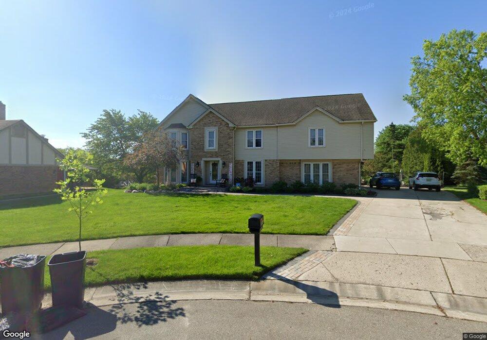
48775 W Normandy Ct Plymouth, MI 48170
Estimated Value: $639,000 - $724,000
--
Bed
4
Baths
3,316
Sq Ft
$209/Sq Ft
Est. Value
About This Home
This home is located at 48775 W Normandy Ct, Plymouth, MI 48170 and is currently estimated at $693,593, approximately $209 per square foot. 48775 W Normandy Ct is a home located in Wayne County with nearby schools including Canton High School, Isbister Elementary School, and Salem High School.
Ownership History
Date
Name
Owned For
Owner Type
Purchase Details
Closed on
Nov 15, 2021
Sold by
Buchanan Rolland C and Buchanan Laureen G
Bought by
Buchanan Rolland C and Buchanan Laureen G
Current Estimated Value
Purchase Details
Closed on
Sep 30, 2019
Sold by
Boring Perry M and Boring Nancy C
Bought by
Buchanan Rolland C and Buchanan Laureen G
Purchase Details
Closed on
Mar 25, 2004
Sold by
Mardegian Larry A and Mardegian Claudia A
Bought by
Buchanan Rolland C
Create a Home Valuation Report for This Property
The Home Valuation Report is an in-depth analysis detailing your home's value as well as a comparison with similar homes in the area
Home Values in the Area
Average Home Value in this Area
Purchase History
| Date | Buyer | Sale Price | Title Company |
|---|---|---|---|
| Buchanan Rolland C | -- | None Available | |
| Buchanan Rolland C | -- | None Available | |
| Buchanan Rolland C | $409,900 | Multiple |
Source: Public Records
Tax History Compared to Growth
Tax History
| Year | Tax Paid | Tax Assessment Tax Assessment Total Assessment is a certain percentage of the fair market value that is determined by local assessors to be the total taxable value of land and additions on the property. | Land | Improvement |
|---|---|---|---|---|
| 2025 | $5,190 | $312,200 | $0 | $0 |
| 2024 | $5,190 | $294,500 | $0 | $0 |
| 2023 | $4,945 | $261,700 | $0 | $0 |
| 2022 | $7,404 | $248,400 | $0 | $0 |
| 2021 | $7,207 | $245,700 | $0 | $0 |
| 2019 | $7,016 | $224,540 | $0 | $0 |
| 2018 | $4,232 | $211,050 | $0 | $0 |
| 2017 | $4,610 | $53,900 | $0 | $0 |
| 2016 | $6,882 | $203,600 | $0 | $0 |
| 2015 | $17,717 | $203,720 | $0 | $0 |
| 2013 | $17,164 | $184,170 | $0 | $0 |
| 2012 | -- | $168,120 | $40,840 | $127,280 |
Source: Public Records
Map
Nearby Homes
- 9377 Pineview Dr
- 48124 Colony Farm Cir
- 9079 Woodgrove Dr
- 9350 Colony Farms Ct
- 48100 Powell Rd
- 9421 Mapletree Dr
- 11809 Amherst Ct
- 9875 Ann Arbor Trail
- 50157 E Fellows Creek Ct
- 0 E Ann Arbor Trail Unit 20251048195
- 11431 Sandalwood Dr
- 48814 Gyde Rd
- 47442 Verona Ct
- 47443 Verona Ct
- 0 N Beck Rd
- 8140 N Pointe Ct
- 47472 Verona Ct
- 48441 N Territorial Rd
- 11641 Chandler Dr
- 7809 Haverhill Ct N
- 48751 W Normandy Ct
- 48797 W Normandy Ct
- 9629 Normandy Dr
- 9757 Normandy Dr
- 9565 Normandy Dr
- 48810 W Normandy Ct
- 9821 Normandy Dr
- 48750 W Normandy Ct
- 48780 W Normandy Ct
- 9794 Hillcrest Dr
- 9872 Hillcrest Dr
- 48691 W Normandy Ct
- 48720 W Normandy Ct
- 9501 Normandy Dr
- 9950 Hillcrest Dr
- 9624 Normandy Dr
- 9686 Normandy Dr
- 9885 Normandy Dr
- 9562 Normandy Dr
- 9748 Normandy Dr