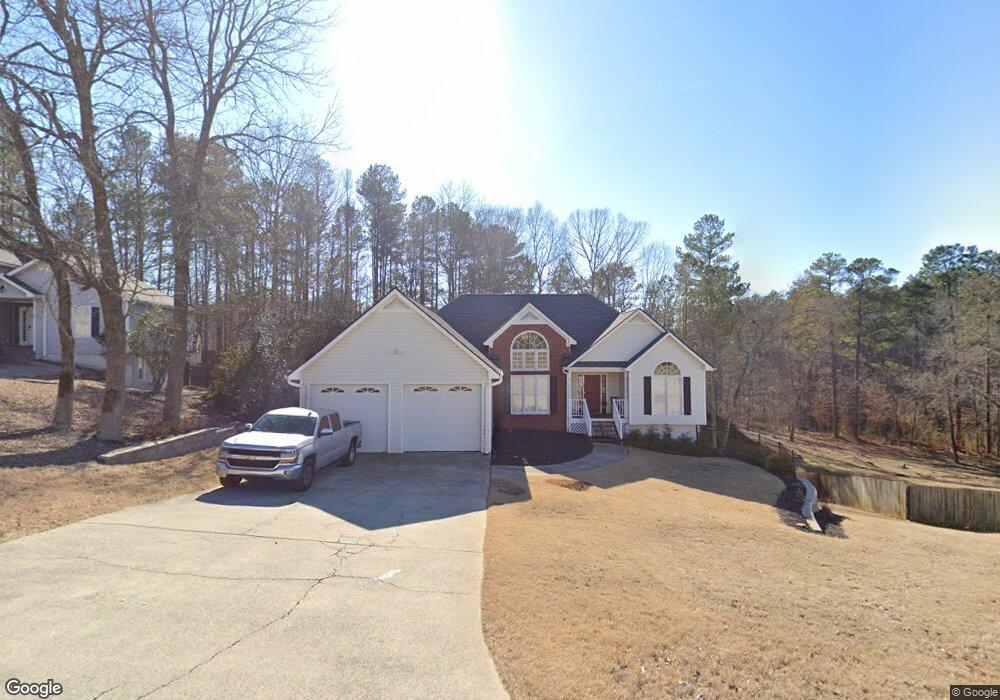
488 Saddle Brooke Dr Dallas, GA 30132
East Paulding County NeighborhoodEstimated Value: $320,000 - $349,134
3
Beds
2
Baths
1,771
Sq Ft
$189/Sq Ft
Est. Value
About This Home
This home is located at 488 Saddle Brooke Dr, Dallas, GA 30132 and is currently estimated at $335,034, approximately $189 per square foot. 488 Saddle Brooke Dr is a home located in Paulding County with nearby schools including Northside Elementary School, Herschel Jones Middle School, and North Paulding High School.
Ownership History
Date
Name
Owned For
Owner Type
Purchase Details
Closed on
Jan 29, 1998
Sold by
Steve Simpson Investment Inc
Bought by
Butler Richard A and Butler Angela C
Current Estimated Value
Home Financials for this Owner
Home Financials are based on the most recent Mortgage that was taken out on this home.
Original Mortgage
$108,400
Outstanding Balance
$19,207
Interest Rate
7.01%
Mortgage Type
New Conventional
Estimated Equity
$315,827
Create a Home Valuation Report for This Property
The Home Valuation Report is an in-depth analysis detailing your home's value as well as a comparison with similar homes in the area
Home Values in the Area
Average Home Value in this Area
Purchase History
| Date | Buyer | Sale Price | Title Company |
|---|---|---|---|
| Butler Richard A | $135,600 | -- |
Source: Public Records
Mortgage History
| Date | Status | Borrower | Loan Amount |
|---|---|---|---|
| Open | Butler Richard A | $108,400 |
Source: Public Records
Tax History Compared to Growth
Tax History
| Year | Tax Paid | Tax Assessment Tax Assessment Total Assessment is a certain percentage of the fair market value that is determined by local assessors to be the total taxable value of land and additions on the property. | Land | Improvement |
|---|---|---|---|---|
| 2024 | $3,258 | $134,204 | $12,000 | $122,204 |
| 2023 | $3,376 | $132,020 | $12,000 | $120,020 |
| 2022 | $2,839 | $110,772 | $12,000 | $98,772 |
| 2021 | $2,504 | $88,032 | $12,000 | $76,032 |
| 2020 | $2,369 | $81,632 | $12,000 | $69,632 |
| 2019 | $2,123 | $72,308 | $12,000 | $60,308 |
| 2018 | $2,113 | $70,124 | $12,000 | $58,124 |
| 2017 | $1,945 | $65,544 | $12,000 | $53,544 |
Source: Public Records
Map
Nearby Homes
- 74 Riders Ridge
- 16 Riders Ridge
- 70 Stallion Run
- The McGinnis Plan at Jones Ridge
- The Langford Plan at Jones Ridge
- The Ellijay Plan at Jones Ridge
- The Palmer Plan at Jones Ridge
- The James Plan at Jones Ridge
- The Lancaster Plan at Jones Ridge
- The Avery Plan at Jones Ridge
- 443 Brooks Rd
- 427 Wagon Trail Cir
- 181 Beckett Dr
- 272 Kades Cove Dr
- 18 Mountain Ct
- 222 River Run Dr
- 222 River Run Dr Unit 82
- 214 River Run Dr
- 214 River Run Dr Unit 83
- 234 River Run Dr
- 510 Saddle Brooke Dr
- 466 Saddle Brooke Dr
- 534 Saddle Brooke Dr
- 499 Saddle Brooke Dr
- 449 Saddle Brooke Dr
- 440 Saddle Brooke Dr
- 535 Saddle Brooke Dr
- 560 Saddle Brooke Dr
- 412 Saddle Brooke Dr
- 411 Saddle Brooke Dr
- 590 Saddle Brooke Dr
- 38 Saddle Horn Place
- 79 Saddle Horn Place
- 383 Saddle Brooke Dr
- 382 Saddle Brooke Dr
- 0 Saddle Horn Place Unit 8697859
- 0 Saddle Horn Place Unit 8031876
- 0 Saddle Horn Place Unit 7627173
- 0 Saddle Horn Place
- 620 Saddle Brooke Dr