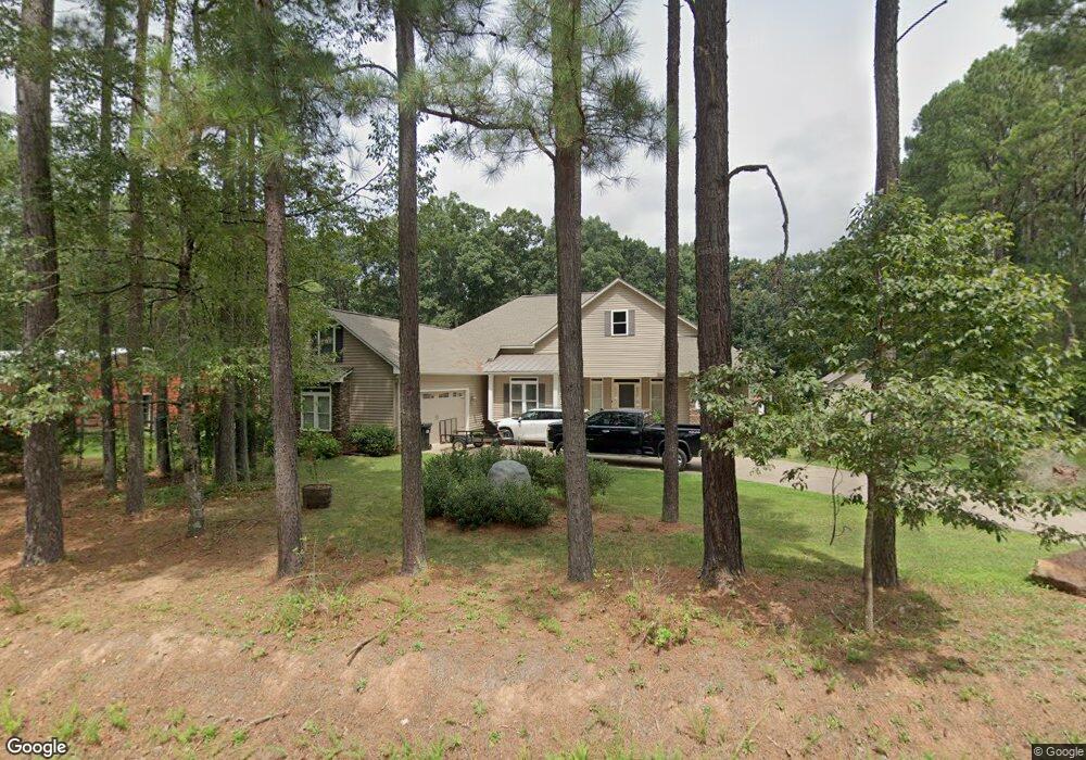
4881 Paysour Pond Rd Iron Station, NC 28080
Estimated Value: $574,000 - $726,289
3
Beds
2
Baths
2,786
Sq Ft
$239/Sq Ft
Est. Value
About This Home
This home is located at 4881 Paysour Pond Rd, Iron Station, NC 28080 and is currently estimated at $665,430, approximately $238 per square foot. 4881 Paysour Pond Rd is a home with nearby schools including East Lincoln Middle School and East Lincoln High School.
Ownership History
Date
Name
Owned For
Owner Type
Purchase Details
Closed on
Mar 13, 2020
Sold by
Wilson Darren Wayne and Wilson Lynn M
Bought by
Wilson Darren Wayne and Wilson Lynn M
Current Estimated Value
Purchase Details
Closed on
Aug 27, 2015
Sold by
Wilson Darren W
Bought by
Wilson Darren W and Wilson Lynn M
Purchase Details
Closed on
May 16, 2007
Sold by
American Land Corporation Charlotte Inc
Bought by
Wilson Darren W
Create a Home Valuation Report for This Property
The Home Valuation Report is an in-depth analysis detailing your home's value as well as a comparison with similar homes in the area
Home Values in the Area
Average Home Value in this Area
Purchase History
| Date | Buyer | Sale Price | Title Company |
|---|---|---|---|
| Wilson Darren Wayne | -- | None Available | |
| Wilson Darren W | -- | None Available | |
| Wilson Darren W | $65,000 | None Available |
Source: Public Records
Tax History Compared to Growth
Tax History
| Year | Tax Paid | Tax Assessment Tax Assessment Total Assessment is a certain percentage of the fair market value that is determined by local assessors to be the total taxable value of land and additions on the property. | Land | Improvement |
|---|---|---|---|---|
| 2025 | $4,237 | $661,812 | $103,711 | $558,101 |
| 2024 | $4,217 | $661,812 | $103,711 | $558,101 |
| 2023 | $4,122 | $661,812 | $103,711 | $558,101 |
| 2022 | $3,043 | $398,149 | $53,878 | $344,271 |
| 2021 | $3,043 | $377,089 | $53,878 | $323,211 |
| 2020 | $2,634 | $323,211 | $0 | $323,211 |
| 2019 | $2,634 | $368,173 | $44,962 | $323,211 |
| 2018 | $2,380 | $313,236 | $42,471 | $270,765 |
| 2017 | $2,279 | $313,236 | $42,471 | $270,765 |
| 2016 | $2,279 | $313,236 | $42,471 | $270,765 |
| 2015 | $2,319 | $313,236 | $42,471 | $270,765 |
| 2014 | $457 | $64,478 | $64,478 | $0 |
Source: Public Records
Map
Nearby Homes
- 4859 Paysour Pond Rd
- 4435 Cornett Dr
- 4394 Mountain Creek Rd
- 6 Hager Mountain Ln
- 1789 Doe Ct
- 1785 Doe Ct
- 222 Oakhill St
- 1713 Oak Park Ct
- 2813 Sadler Rd
- 3323 Sadler Rd
- 0 Oak Park Ct Unit 17
- 1615 Oak Park Ct
- 0 Wolf Rd Unit 8
- 5039 Penn Rd
- Lot #42 Sardis Ct
- 1279 Craig Dr
- 1208 Mariposa Rd
- 5756 Rumfelt Rd
- 5486 E Highway 27
- 5329 E Highway 27 Hwy
- Lot 2 Paysour Pond Rd
- Lot 25 Outlook Dr
- 025 Outlook Dr Unit Lot 25
- 026 Cornett Dr Unit Lot 26
- Lot 26 Cornett Dr
- 004 Outlook Dr Unit Lot 4
- 4895 Paysour Pond Rd
- Lot 4 Outlook Dr
- 4823 Paysour Pond Rd
- 5 Outlook Dr
- 23 Outlook Dr Unit Lot 23
- 4811 Paysour Pond Rd
- 4455 Cornett Dr
- 4473 Mountain Creek Rd
- 0 Outlook Dr Unit 13 CAR3866006
- #13 Outlook Dr Unit 13
- 0 Outlook Dr
- 4495 Outlook Dr
- 4495 Outlook Dr Unit 6
- 4494 Outlook Dr