NOT LISTED FOR SALE

489 Grouse Rd Sandpoint, ID 83864

Estimated Value: $362,000 - $450,000

10 Acres
$39,399 Price per Acre
442,134 Sq Ft Lot

Last Sold June 28, 2016

Current estimated payment $2,274/month

272 Days on Market

Highlights

  • Water Access
  • 10.15 Acre Lot
  • Trails
  • Panoramic View
  • Mature Trees
  • Level Lot

About This Lot

As of June 2016

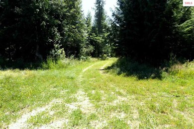
This peaceful and private 10 acre building site features level topography with a combination of southern exposure, open meadows and wooded areas for enjoying the wildlife. Power is at the property. Existing well is low producing, so buyer may want to drill a new well. Previous septic system installed has had interrupted use and will require a new application and permit process. Ideal setting for a new home with plenty of room for additional outbuildings. Extra bonus includes river access with “deeded” community waterfront! Priced to sell!

Last Agent to Sell the Property

Cindy Bond

eXp REALTY LLC License #AB24659 Listed on: 09/08/2015

eXp REALTY LLC

Last Buyer's Agent

NON AGENT

NON AGENCY

Property Details

Property Type

  • Land

Est. Annual Taxes

  • $319

Lot Details

  • 10.15 Acre Lot
  • Property fronts a private road
  • Level Lot
  • Mature Trees
  • Wooded Lot
  • Property is zoned Rural

Property Views

  • Panoramic
  • Mountain

Utilities

  • Electricity To Lot Line
  • Well
  • Septic System

Community Details

  • Trails
  • Water Access

Listing and Financial Details

  • Assessor Parcel Number RP005140010070A

Property Details

Property Type

Land

Est. Annual Taxes

$319

Lot Details

0

Listing Details

  • Class: VACANT LAND
  • Type: Vacant Land
  • Broken Out: Yes
  • Covenant Restrictions: No
  • Financing2: Cash, Conventional
  • Fire District: Northside
  • Fire District: Yes
  • Geo Subdivision: ID
  • Known L I D: No
  • Main Body Of Water: Pack River
  • Section: 25
  • Share With Assessor: Yes
  • Taxes: 319
  • Type Of Contract: Exclusive Right to Sell
  • Water Access Location: Main
  • Water Access Type: Deeded (Not Contiguous)
  • Water Access Y N: Yes
  • Zoning Designation: RURAL 5
  • Mobile Manufactured Allowed: Yes
  • Property Amenities: Trail System
  • Land Characteristics: Wooded, Level, Mountain View, Panoramic View, Part Fenced, Mature Trees, Southern Exposure
  • Special Features: None
  • Property Sub Type: LotsLands

Interior Features

  • Waterfront: No

Exterior Features

  • Road Access: Private Road
  • Road Surface: Gravel

Utilities

  • Electricity: On Site
  • Sewer: Septic
  • Water System: Well
  • Garbage: No Info
  • Natural Gas: No Info

Lot Info

  • Geo Update Timestamp: 2016-06-29
  • Estimated Number Acres: 10.15
  • Geo Address Line: 489 Grouse Rd
  • Geo Longitude: -116.5291901
  • Geo Primary City: Sandpoint
  • Geo Quality: 0.95
  • Geo Secondary City: Bonner Co.
  • Geo Zoom Level: 17
  • Parcel Number: RP005140010070A
  • Price Per Acre: 6798.03

Tax Info

  • Tax Database I D: 1
  • Assessor Parcel Number: RP005140010070A
  • Tax Year: 2013

MLS Schools

  • School District: Lake Pend Oreille

Ownership History

Date Name Owned For Owner Type

Purchase Details

Listed on
Dec 31, 2013
Closed on
Jan 23, 2014
Sold by
Hulett William
Bought by
Meekings David E and Meekings Marilyn J
Seller's Agent
Lana Kay Hanson
LANA KAY REALTY
Buyer's Agent
Cindy Bond
eXp REALTY LLC
List Price
$69,900
Sold Price
$60,000
Premium/Discount to List
-$9,900
-14.16%
Current Estimated Value
$399,899

Home Financials for this Owner

Home Financials are based on the most recent Mortgage that was taken out on this home.
Estimated Appreciation
$339,899
Avg. Annual Appreciation
18.03%

Purchase Details

Closed on
May 30, 2013
Sold by
Stratemeyer Tina Lynn
Bought by
Hulett William and The Hulett Family Trust

Purchase Details

Closed on
May 18, 2006
Sold by
Nolan Maxwell D and Nolan Laura S
Bought by
Stratemeyer Tina Lynn

Home Financials for this Owner

Home Financials are based on the most recent Mortgage that was taken out on this home.
Original Mortgage
$47,000
Interest Rate
6.41%
Mortgage Type
Purchase Money Mortgage
Source: Public Records

Range of Values:

Collateral Analytics

Collateral Analytics Collateral Analytics AVMs (Automated Valuation Model) employ a number of statistical approaches combined with neighborhood-specific comparable selection guarantees the most up-to-date and precise valuations.

Not Available

Collateral Analytics does not have data for the current month. Please view the chart for historical values.

ICE

ICE Mortgage Technology ICE Mortgage Technology’s AVM (Automated Valuation Model) is a state-of-the-art online residential property valuation tool that provides a quick and accurate estimate of the value of almost any home in the U.S.

Not Available

ICE Mortgage Technology does not have data for the current month. Please view the chart for historical values.

First American

First American First American Data & Analytics’ next-generation AVM combines unrivaled data assets with a blended ensemble of valuation models to produce highly accurate, reliable valuations you can trust.

Not Available

First American does not have data for the current month. Please view the chart for historical values.

Quantarium

Quantarium Quantarium’s valuation service, repeatedly proven the industry’s most accurate and comprehensive, is supercharged with a self-learning and auto-tuning AI engine that continually becomes smarter and more accurate as it processes daily inputs from the industry’s leading RE data lake.

Not Available

Quantarium does not have data for the current month. Please view the chart for historical values.

Average Value
Not Available
List Price
Sold Price
Create a Home Valuation Report for This Property
The Home Valuation Report is an in-depth analysis detailing your home's value as well as a comparison with similar homes in the area

Home Values in the Area

Source: Public Records

Average Home Value in this Area


Source: Public Records

Purchase History

Date Buyer Sale Price Title Company
Meekings David E -- First American Title Sand
Hulett William $71,809 None Available
Stratemeyer Tina Lynn -- --
Source: Public Records

Mortgage History

Date Status Borrower Loan Amount
Open Helsley Robert L $60,000
Previous Owner Stratemeyer Tina Lynn $47,000
Source: Public Records

Property History

Date Event Price Change Sq Ft Price
06/28/2016 06/28/16 Sold -- -- --
06/06/2016 06/06/16 Pending -- -- --
09/08/2015 09/08/15 For Sale $69,900 0.0% --
02/07/2014 02/07/14 Sold -- -- --
01/15/2014 01/15/14 Pending -- -- --
12/31/2013 12/31/13 For Sale $69,900 -- --
Source: Selkirk Association of REALTORS®

Tax History Compared to Growth

Source: Public Records

Tax History

Year Tax Paid Tax Assessment Tax Assessment Total Assessment is a certain percentage of the fair market value that is determined by local assessors to be the total taxable value of land and additions on the property. Land Improvement
2024 $705 $222,907 $119,897 $103,010
2023 $629 $233,522 $119,751 $113,771
2022 $746 $233,818 $98,878 $134,940
2021 $675 $133,332 $59,730 $73,602
2020 $482 $66,395 $60,261 $6,134
2019 $713 $54,496 $50,356 $4,140
2018 $586 $94,072 $90,648 $3,424
2017 $586 $73,247 $0 $0
2016 $511 $61,036 $0 $0
2015 -- $58,131 $0 $0
2014 -- $49,224 $0 $0
Source: Public Records

Agents Affiliated with this Home

  • Section Image
  • Section Image
See All Agents

Map

Source: Selkirk Association of REALTORS®

MLS Number: 20153062

Selkirk Association of REALTORS®

APN: RP005-140-010070A