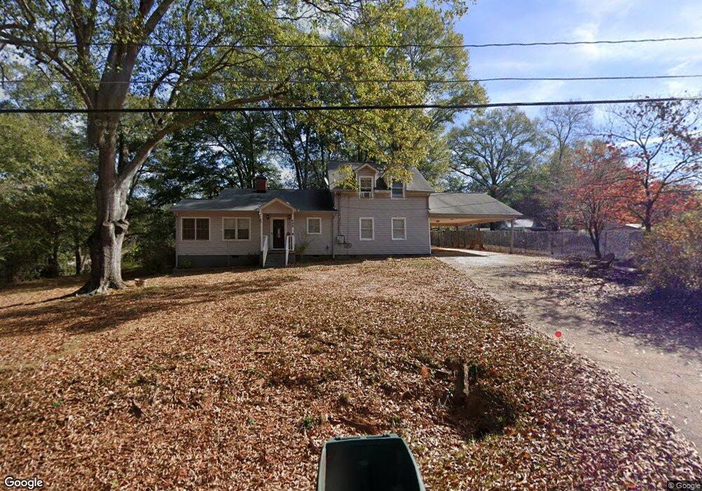
489 Orchard Cir Commerce, GA 30529
Estimated Value: $279,000 - $309,000
4
Beds
2
Baths
1,855
Sq Ft
$157/Sq Ft
Est. Value
About This Home
This home is located at 489 Orchard Cir, Commerce, GA 30529 and is currently estimated at $291,633, approximately $157 per square foot. 489 Orchard Cir is a home located in Jackson County with nearby schools including Commerce Primary School, Commerce Elementary School, and Commerce Middle School.
Ownership History
Date
Name
Owned For
Owner Type
Purchase Details
Closed on
Jul 8, 2021
Sold by
Mccuen Joshua
Bought by
Hesse Donald
Current Estimated Value
Home Financials for this Owner
Home Financials are based on the most recent Mortgage that was taken out on this home.
Original Mortgage
$180,000
Outstanding Balance
$161,704
Interest Rate
2.96%
Mortgage Type
New Conventional
Estimated Equity
$129,929
Purchase Details
Closed on
Oct 3, 2016
Sold by
Cash Angela
Bought by
Mccuen Joshua
Home Financials for this Owner
Home Financials are based on the most recent Mortgage that was taken out on this home.
Original Mortgage
$127,687
Interest Rate
3.46%
Mortgage Type
VA
Purchase Details
Closed on
May 3, 1999
Sold by
Cash Todd and Cash Angela C
Bought by
Cash Angela
Create a Home Valuation Report for This Property
The Home Valuation Report is an in-depth analysis detailing your home's value as well as a comparison with similar homes in the area
Home Values in the Area
Average Home Value in this Area
Purchase History
| Date | Buyer | Sale Price | Title Company |
|---|---|---|---|
| Hesse Donald | $225,000 | -- | |
| Mccuen Joshua | $125,000 | -- | |
| Cash Angela | -- | -- |
Source: Public Records
Mortgage History
| Date | Status | Borrower | Loan Amount |
|---|---|---|---|
| Open | Hesse Donald | $180,000 | |
| Previous Owner | Mccuen Joshua | $127,687 |
Source: Public Records
Tax History
| Year | Tax Paid | Tax Assessment Tax Assessment Total Assessment is a certain percentage of the fair market value that is determined by local assessors to be the total taxable value of land and additions on the property. | Land | Improvement |
|---|---|---|---|---|
| 2025 | $1,894 | $70,920 | $14,040 | $56,880 |
| 2024 | $1,894 | $70,920 | $14,040 | $56,880 |
| 2023 | $1,958 | $70,920 | $14,040 | $56,880 |
| 2022 | $1,786 | $55,080 | $10,520 | $44,560 |
| 2021 | $1,783 | $55,080 | $10,520 | $44,560 |
| 2020 | $1,668 | $46,040 | $10,520 | $35,520 |
| 2019 | $1,692 | $46,040 | $10,520 | $35,520 |
| 2018 | $1,615 | $44,320 | $10,520 | $33,800 |
| 2017 | $1,535 | $41,384 | $10,536 | $30,848 |
| 2016 | $1,473 | $40,120 | $9,272 | $30,848 |
| 2015 | $1,507 | $40,120 | $9,272 | $30,848 |
| 2014 | $1,192 | $31,620 | $9,272 | $22,349 |
| 2013 | -- | $33,110 | $9,271 | $23,838 |
Source: Public Records
Map
Nearby Homes
- 162 Orchard Cir
- 131 Roosevelt Blvd
- 245 Hospital Rd
- 245 Homer Rd
- 2140 N Broad St
- 0 Ridgeway St
- 321 Pine Ave
- 83 Ridgeway Dr
- 286 Pine Ave
- 51 Pine Ave
- 304 Hill St
- 3142 Maysville Rd
- 25 Beckett Way
- 92 Duncan St Unit LOT 1 AND 2
- 3162 Maysville Rd
- 8569 Jefferson Rd
- 177 Bolton Dr
- 178 Cole Court Dr
- 31 Coles Court Dr
- 378 Baugh St
- 477 Orchard Cir
- 2530 N Broad St
- 103 Brookwood Ave
- 2512 N Broad St
- 2496 N Broad St
- 69 Brookwood Ave
- 2574 N Broad St
- 165 Brookwood Ave
- 122 Orchard Dr
- 154 Orchard Cir
- 154 Orchard Dr
- 96 Orchard Dr Unit O
- 96 Orchard Dr
- 184 Orchard Dr
- 96 Brookwood Ave
- 170 Orchard Dr
- 88 Brookwood Ave
- 2481 N Broad St
- 2458 N Broad St
- 122 Brookwood Ave
Your Personal Tour Guide
Ask me questions while you tour the home.