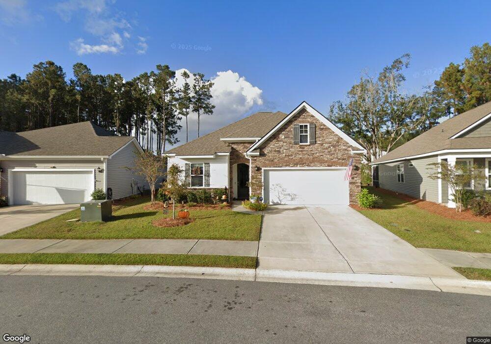
489 Rye Creek Cir Bluffton, SC 29909
Cypress Ridge NeighborhoodEstimated Value: $421,475 - $468,000
3
Beds
2
Baths
1,714
Sq Ft
$264/Sq Ft
Est. Value
About This Home
This home is located at 489 Rye Creek Cir, Bluffton, SC 29909 and is currently estimated at $452,119, approximately $263 per square foot. 489 Rye Creek Cir is a home located in Beaufort County with nearby schools including Pritchardville Elementary School, H.E. McCracken Middle School, and May River High School.
Ownership History
Date
Name
Owned For
Owner Type
Purchase Details
Closed on
Sep 17, 2021
Sold by
Nehring Philip Joseph and Nehring Roberta Denise
Bought by
Crawford Terw Lea and Crawford Terri L
Current Estimated Value
Home Financials for this Owner
Home Financials are based on the most recent Mortgage that was taken out on this home.
Original Mortgage
$200,000
Outstanding Balance
$181,985
Interest Rate
2.8%
Mortgage Type
New Conventional
Estimated Equity
$270,134
Purchase Details
Closed on
Aug 10, 2020
Sold by
D R Horton Inc
Bought by
Nehring Philip Joseph and Nehring Roberta Denise
Home Financials for this Owner
Home Financials are based on the most recent Mortgage that was taken out on this home.
Original Mortgage
$269,535
Interest Rate
3%
Mortgage Type
FHA
Create a Home Valuation Report for This Property
The Home Valuation Report is an in-depth analysis detailing your home's value as well as a comparison with similar homes in the area
Home Values in the Area
Average Home Value in this Area
Purchase History
| Date | Buyer | Sale Price | Title Company |
|---|---|---|---|
| Crawford Terw Lea | $359,900 | None Available | |
| Nehring Philip Joseph | $279,990 | None Available |
Source: Public Records
Mortgage History
| Date | Status | Borrower | Loan Amount |
|---|---|---|---|
| Open | Crawford Terw Lea | $200,000 | |
| Previous Owner | Nehring Philip Joseph | $269,535 |
Source: Public Records
Tax History Compared to Growth
Tax History
| Year | Tax Paid | Tax Assessment Tax Assessment Total Assessment is a certain percentage of the fair market value that is determined by local assessors to be the total taxable value of land and additions on the property. | Land | Improvement |
|---|---|---|---|---|
| 2024 | $2,473 | $14,300 | $1,880 | $12,420 |
| 2023 | $2,473 | $14,300 | $1,880 | $12,420 |
| 2022 | $2,617 | $14,396 | $1,880 | $12,516 |
| 2021 | $5,035 | $11,200 | $1,880 | $9,320 |
| 2020 | $895 | $2,820 | $0 | $0 |
Source: Public Records
Map
Nearby Homes
- 481 Rye Creek Cir
- 497 Rye Creek Cir
- 506 Rye Creek Cir
- 406 Rye Creek Cir
- 120 Sifted Grain Rd
- 572 Hulston Landing Rd
- 82 Sifted Grain Rd
- 524 Hulston Landing Rd
- 587 Hulston Landing Rd
- 591 Hulston Landing Rd
- 9 Stone Hearth Ct
- 93 Estuary Dr
- 91 Estuary Dr
- 95 Estuary Dr
- 87 Estuary Dr
- 5 Cedar View Cir
- 360 Great Harvest Rd
- 364 Great Harvest Rd
- 493 Rye Creek Cir
- 485 Rye Creek Cir
- 486 Rye Creek Cir
- 134 Bedstone Ct
- 494 Rye Creek Cir
- 501 Rye Creek Cir
- 130 Bedstone Ct
- 477 Rye Creek Cir
- 498 Rye Creek Cir
- 138 Bedstone Ct
- 502 Rye Creek Cir
- 509 Rye Creek Cir
- 474 Rye Creek Cir
- 469 Rye Creek Cir
- 513 Rye Creek Cir
- 462 Rye Creek Cir
- 142 Bedstone Ct
- 465 Rye Creek Cir
- 118 Bedstone Ct
- 510 Rye Creek Cir