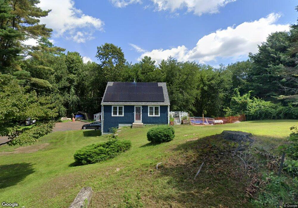
49 Acres of Pine Rd Coventry, RI 02816
Estimated Value: $401,202 - $450,000
3
Beds
1
Bath
1,008
Sq Ft
$426/Sq Ft
Est. Value
About This Home
This home is located at 49 Acres of Pine Rd, Coventry, RI 02816 and is currently estimated at $429,551, approximately $426 per square foot. 49 Acres of Pine Rd is a home located in Kent County with nearby schools including Alan Shawn Feinstein Ms Of Cov, Coventry High School, and Father John V. Doyle School.
Ownership History
Date
Name
Owned For
Owner Type
Purchase Details
Closed on
Jan 10, 2020
Sold by
Davis Richard A and Davis Deborah A
Bought by
Degnan Dawn C
Current Estimated Value
Home Financials for this Owner
Home Financials are based on the most recent Mortgage that was taken out on this home.
Original Mortgage
$172,000
Outstanding Balance
$152,261
Interest Rate
3.7%
Mortgage Type
New Conventional
Estimated Equity
$277,290
Purchase Details
Closed on
Feb 7, 2018
Sold by
Degnan Dawn C and Lodge Awn C
Bought by
Degnan Dawn C
Home Financials for this Owner
Home Financials are based on the most recent Mortgage that was taken out on this home.
Original Mortgage
$177,000
Interest Rate
3.99%
Mortgage Type
New Conventional
Purchase Details
Closed on
Dec 20, 1993
Sold by
Peiczarka David A and Peiczarka Linda
Bought by
Lodge David M and Lodge Dawn
Create a Home Valuation Report for This Property
The Home Valuation Report is an in-depth analysis detailing your home's value as well as a comparison with similar homes in the area
Home Values in the Area
Average Home Value in this Area
Purchase History
| Date | Buyer | Sale Price | Title Company |
|---|---|---|---|
| Degnan Dawn C | -- | None Available | |
| Degnan Dawn C | -- | -- | |
| Lodge David M | $115,000 | -- |
Source: Public Records
Mortgage History
| Date | Status | Borrower | Loan Amount |
|---|---|---|---|
| Open | Degnan Dawn C | $172,000 | |
| Previous Owner | Degnan Dawn C | $177,000 | |
| Previous Owner | Lodge David M | $196,400 | |
| Previous Owner | Lodge David M | $201,500 | |
| Previous Owner | Lodge David M | $193,200 | |
| Previous Owner | Lodge David M | $100,000 |
Source: Public Records
Tax History Compared to Growth
Tax History
| Year | Tax Paid | Tax Assessment Tax Assessment Total Assessment is a certain percentage of the fair market value that is determined by local assessors to be the total taxable value of land and additions on the property. | Land | Improvement |
|---|---|---|---|---|
| 2024 | $4,880 | $308,100 | $156,000 | $152,100 |
| 2023 | $4,723 | $308,100 | $156,000 | $152,100 |
| 2022 | $4,761 | $243,300 | $140,000 | $103,300 |
| 2021 | $4,720 | $243,300 | $140,000 | $103,300 |
| 2020 | $5,411 | $243,300 | $140,000 | $103,300 |
| 2019 | $5,082 | $228,500 | $132,000 | $96,500 |
| 2018 | $4,938 | $228,500 | $132,000 | $96,500 |
| 2017 | $4,794 | $228,500 | $132,000 | $96,500 |
| 2016 | $4,432 | $207,000 | $124,900 | $82,100 |
| 2015 | $4,312 | $207,000 | $124,900 | $82,100 |
| 2014 | $4,222 | $207,000 | $124,900 | $82,100 |
| 2013 | $3,799 | $203,600 | $122,400 | $81,200 |
Source: Public Records
Map
Nearby Homes
- 0 Poor Farm Lot 68 Rd
- 0 Poor Farm Lot 69 Rd
- 0 Poor Farm Lot 67 Rd
- 170 Acres of Pine Rd
- 17 Paige Dr
- 60 Town Farm Rd
- 207 Shady Valley Rd
- 93 Provident Place
- 35 Provident Place
- 145 Phillips Hill Rd
- 870 Hill Farm Rd
- 83 Sunset Lake Cir
- 1 Whitehead Rd
- 0 Whitehead Rd Unit 1395877
- 2 Whitehead Rd
- 51 Sunset Lake Cir
- 81 Sunset Lake Cir
- 12 Pine Way Blvd
- 6 Boyd Brook Cir
- 0 Town Farm Rd
- 48 Acres of Pine Rd
- 52 Acres of Pine Rd
- 37 Acres of Pine Rd
- 44 Acres of Pine Rd
- 42 Acres of Pine Rd
- 54 Acres of Pine Rd
- 51 Acres of Pine Rd
- 63 Acres of Pine Rd
- 40 Acres of Pine Rd
- 56 Acres of Pine Rd
- 29 Acres of Pine Rd
- 38 Acres of Pine Rd
- 58 Acres of Pine Rd
- 36 Acres of Pine Rd
- 60 Acres of Pine Rd
- 27 Acres of Pine Rd
- 55 Acres of Pine Rd
- 32 Acres of Pine Rd
- 30 Acres of Pine Rd
- 21 Acres of Pine Rd