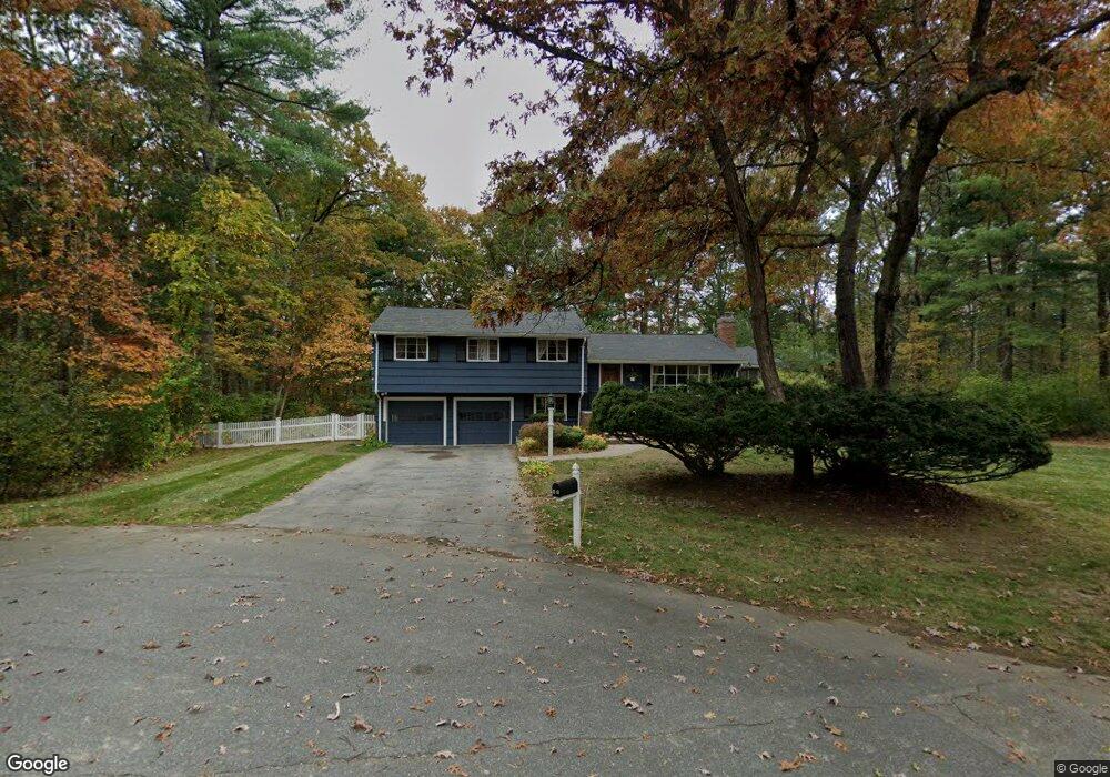
49 Austin Rd Sudbury, MA 01776
Estimated Value: $855,922 - $1,039,000
4
Beds
3
Baths
1,764
Sq Ft
$550/Sq Ft
Est. Value
About This Home
This home is located at 49 Austin Rd, Sudbury, MA 01776 and is currently estimated at $970,731, approximately $550 per square foot. 49 Austin Rd is a home located in Middlesex County with nearby schools including Peter Noyes Elementary School, Ephraim Curtis Middle School, and Lincoln-Sudbury Regional High School.
Ownership History
Date
Name
Owned For
Owner Type
Purchase Details
Closed on
Apr 25, 1991
Sold by
Hurd Richard N and Hurd Jocelyn
Bought by
Carder Frank B and Carder Ellen
Current Estimated Value
Home Financials for this Owner
Home Financials are based on the most recent Mortgage that was taken out on this home.
Original Mortgage
$206,000
Interest Rate
9.41%
Mortgage Type
Purchase Money Mortgage
Create a Home Valuation Report for This Property
The Home Valuation Report is an in-depth analysis detailing your home's value as well as a comparison with similar homes in the area
Home Values in the Area
Average Home Value in this Area
Purchase History
| Date | Buyer | Sale Price | Title Company |
|---|---|---|---|
| Carder Frank B | $215,000 | -- |
Source: Public Records
Mortgage History
| Date | Status | Borrower | Loan Amount |
|---|---|---|---|
| Closed | Carder Frank B | $206,000 |
Source: Public Records
Tax History
| Year | Tax Paid | Tax Assessment Tax Assessment Total Assessment is a certain percentage of the fair market value that is determined by local assessors to be the total taxable value of land and additions on the property. | Land | Improvement |
|---|---|---|---|---|
| 2025 | $11,842 | $808,900 | $419,900 | $389,000 |
| 2024 | $11,448 | $783,600 | $407,600 | $376,000 |
| 2023 | $11,389 | $722,200 | $377,400 | $344,800 |
| 2022 | $10,628 | $588,800 | $346,400 | $242,400 |
| 2021 | $10,202 | $541,800 | $346,400 | $195,400 |
| 2020 | $9,996 | $541,800 | $346,400 | $195,400 |
| 2019 | $9,704 | $541,800 | $346,400 | $195,400 |
| 2018 | $9,575 | $534,000 | $369,300 | $164,700 |
| 2017 | $8,960 | $505,100 | $351,300 | $153,800 |
| 2016 | $8,720 | $489,900 | $337,900 | $152,000 |
| 2015 | $8,203 | $466,100 | $324,900 | $141,200 |
| 2014 | $8,168 | $453,000 | $315,400 | $137,600 |
Source: Public Records
Map
Nearby Homes
- 30 Kendall Rd
- 53 Pine St
- 30 Rolling Ln
- 557 Dutton Rd Unit 2
- 0 Robbins Rd
- 0 Boston Post Rd
- 123 Dutton Rd
- 725 Boston Post Rd Unit 12
- 11 Great Lake Dr
- 15 Harness Ln
- 62 Churchill St
- 30 Harness Ln
- 11 October Rd
- 11 Farmstead Ln Unit 11
- 22 Barracks Rd Unit 22
- 24 Woodland Rd
- 45 Webster Cir
- 1011 Boston Post Rd
- 62 Hawkins Ln
- 788 Main St
Your Personal Tour Guide
Ask me questions while you tour the home.