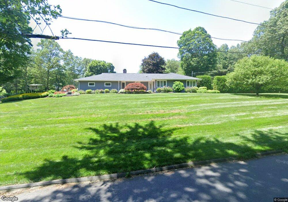
49 Brainard Rd Wilbraham, MA 01095
Estimated Value: $509,193 - $551,000
3
Beds
4
Baths
2,335
Sq Ft
$228/Sq Ft
Est. Value
About This Home
This home is located at 49 Brainard Rd, Wilbraham, MA 01095 and is currently estimated at $532,298, approximately $227 per square foot. 49 Brainard Rd is a home located in Hampden County with nearby schools including Minnechaug Regional High School, St. John the Baptist School, and Wilbraham & Monson Academy.
Ownership History
Date
Name
Owned For
Owner Type
Purchase Details
Closed on
Jan 9, 2014
Sold by
Scatolini Carol A
Bought by
Scatolini Carol A and Gardner Patricia
Current Estimated Value
Purchase Details
Closed on
Jun 15, 2005
Sold by
Archambault Rita R
Bought by
Scatolini Carol A
Home Financials for this Owner
Home Financials are based on the most recent Mortgage that was taken out on this home.
Original Mortgage
$256,000
Interest Rate
5.78%
Mortgage Type
Purchase Money Mortgage
Create a Home Valuation Report for This Property
The Home Valuation Report is an in-depth analysis detailing your home's value as well as a comparison with similar homes in the area
Home Values in the Area
Average Home Value in this Area
Purchase History
| Date | Buyer | Sale Price | Title Company |
|---|---|---|---|
| Scatolini Carol A | -- | -- | |
| Scatolini Carol A | $320,000 | -- |
Source: Public Records
Mortgage History
| Date | Status | Borrower | Loan Amount |
|---|---|---|---|
| Previous Owner | Scatolini Carol A | $250,750 | |
| Previous Owner | Scatolini Carol A | $256,000 | |
| Previous Owner | Scatolini Carol A | $32,000 |
Source: Public Records
Tax History Compared to Growth
Tax History
| Year | Tax Paid | Tax Assessment Tax Assessment Total Assessment is a certain percentage of the fair market value that is determined by local assessors to be the total taxable value of land and additions on the property. | Land | Improvement |
|---|---|---|---|---|
| 2025 | $8,647 | $483,600 | $73,700 | $409,900 |
| 2024 | $8,318 | $449,600 | $73,700 | $375,900 |
| 2023 | $7,116 | $407,500 | $73,700 | $333,800 |
| 2022 | $7,116 | $347,300 | $73,700 | $273,600 |
| 2021 | $6,590 | $287,000 | $80,400 | $206,600 |
| 2020 | $6,423 | $287,000 | $80,400 | $206,600 |
| 2019 | $6,263 | $287,300 | $80,400 | $206,900 |
| 2018 | $5,807 | $256,500 | $80,400 | $176,100 |
| 2017 | $5,606 | $254,800 | $80,400 | $174,400 |
| 2016 | $5,355 | $247,900 | $85,300 | $162,600 |
| 2015 | $5,176 | $247,900 | $85,300 | $162,600 |
Source: Public Records
Map
Nearby Homes
- 19 Linwood Dr
- 10 Forest Glade Dr
- 24 Lodge Ln Unit 24
- 6 Teak Terrace Unit 24
- 116 Cherry Dr Unit 116
- 57 Sandalwood Dr Unit site 61
- 111 Sandalwood Dr Unit site 00
- 99 Sandalwood Dr Unit site 00
- 103 Sandalwood Dr Unit site 00
- 26 Sandalwood Dr
- 2205 Boston Rd Unit I 82
- 8 Glenn Dr
- 15 Sandalwood Dr Unit site 00
- 344 Stony Hill Rd
- 46 Washington Rd
- 6V Melikian Dr
- 4 Hillcrest Dr
- 11 Wellfleet Dr
- 34 Blacksmith Rd
- 35 Lake Dr
- 58 Glenn Dr
- 59 Glenn Dr
- 48 Brainard Rd
- 47 Brainard Rd
- 50 Brainard Rd
- 56 Glenn Dr
- 52 Brainard Rd
- 212 Manchonis rd Extension
- 57 Glenn Dr
- 46 Brainard Rd
- 53 Brainard Rd
- 212 Manchonis Rd
- 54 Brainard Rd
- 216 Manchonis rd Extension
- 200 Manchonis rd Extension
- 54 Glenn Dr
- 55 Brainard Rd
- 55 Glenn Dr
- 56 Brainard Rd
- 44 Brainard Rd