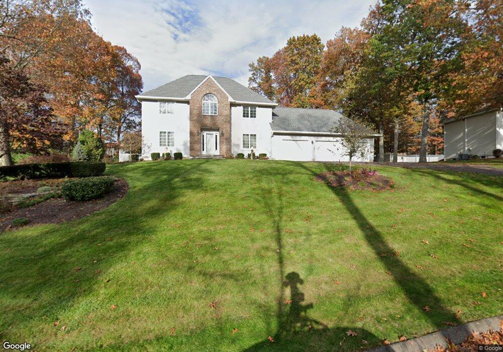
49 Charing Rd South Windsor, CT 06074
Estimated Value: $703,000 - $794,000
4
Beds
3
Baths
3,082
Sq Ft
$247/Sq Ft
Est. Value
About This Home
This home is located at 49 Charing Rd, South Windsor, CT 06074 and is currently estimated at $760,285, approximately $246 per square foot. 49 Charing Rd is a home located in Hartford County with nearby schools including Timothy Edwards School, South Windsor High School, and St Bridget School.
Ownership History
Date
Name
Owned For
Owner Type
Purchase Details
Closed on
Apr 26, 1995
Sold by
Charing Rd Lp
Bought by
U&R Constr Co Inc
Current Estimated Value
Purchase Details
Closed on
Jan 25, 1995
Sold by
U & R Constr Co Inc
Bought by
Lang James and Lang Susan
Create a Home Valuation Report for This Property
The Home Valuation Report is an in-depth analysis detailing your home's value as well as a comparison with similar homes in the area
Home Values in the Area
Average Home Value in this Area
Purchase History
| Date | Buyer | Sale Price | Title Company |
|---|---|---|---|
| U&R Constr Co Inc | $75,000 | -- | |
| Lang James | $328,000 | -- |
Source: Public Records
Mortgage History
| Date | Status | Borrower | Loan Amount |
|---|---|---|---|
| Closed | Lang James | $71,000 | |
| Closed | Lang James | $107,000 | |
| Closed | Lang James | $80,000 |
Source: Public Records
Tax History
| Year | Tax Paid | Tax Assessment Tax Assessment Total Assessment is a certain percentage of the fair market value that is determined by local assessors to be the total taxable value of land and additions on the property. | Land | Improvement |
|---|---|---|---|---|
| 2025 | $15,252 | $428,300 | $137,100 | $291,200 |
| 2024 | $14,759 | $428,300 | $137,100 | $291,200 |
| 2023 | $14,194 | $428,300 | $137,100 | $291,200 |
| 2022 | $12,802 | $330,200 | $130,000 | $200,200 |
| 2021 | $12,501 | $330,200 | $130,000 | $200,200 |
| 2020 | $12,508 | $330,200 | $130,000 | $200,200 |
| 2019 | $12,713 | $330,200 | $130,000 | $200,200 |
| 2018 | $5,833 | $154,840 | $130,000 | $24,840 |
| 2017 | $12,182 | $319,900 | $130,000 | $189,900 |
| 2016 | $11,945 | $319,900 | $130,000 | $189,900 |
| 2015 | $11,689 | $319,900 | $130,000 | $189,900 |
| 2014 | $11,360 | $319,900 | $130,000 | $189,900 |
Source: Public Records
Map
Nearby Homes
- 11 Mara Trail
- 52 Woodland Dr
- 10 Devonshire Dr
- 49 Deepwood Dr
- 348 Avery St
- 35 Vincent Cir
- 325 Kelly Rd Unit TRLR R19
- 325 Kelly Rd Unit TRLR A6
- 325 Kelly Rd Unit TRLR S9
- 1106 Summer Hill Dr
- 37 Vista View Ln Unit 37
- 1503 Summer Hill Dr
- 12 Shady Brook Ln
- 506 Summer Hill Dr Unit 506
- 95 Meadowview Ln
- 33 Imperial Dr
- 16 Foxglove Ln Unit 16
- 194 Lisa Dr
- 59 Wapping Wood Rd
- 11 Allison Rd
Your Personal Tour Guide
Ask me questions while you tour the home.