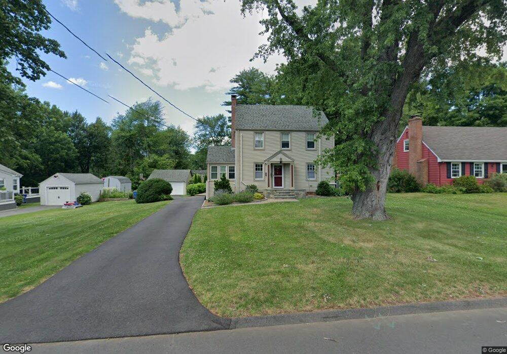
49 Dudley Rd Wethersfield, CT 06109
Estimated Value: $454,000 - $479,000
3
Beds
2
Baths
2,054
Sq Ft
$227/Sq Ft
Est. Value
About This Home
This home is located at 49 Dudley Rd, Wethersfield, CT 06109 and is currently estimated at $465,709, approximately $226 per square foot. 49 Dudley Rd is a home located in Hartford County with nearby schools including Emerson-Williams School, Silas Deane Middle School, and Wethersfield High School.
Ownership History
Date
Name
Owned For
Owner Type
Purchase Details
Closed on
Dec 23, 2021
Sold by
Porriello Janet H
Bought by
Janet H Porriello Lt
Current Estimated Value
Purchase Details
Closed on
Jul 13, 2015
Sold by
Porriello John A
Bought by
Porriello Janet H
Purchase Details
Closed on
Jul 21, 1997
Sold by
Belanger Marjorie B
Bought by
Porriello Janet H and Porriello John A
Create a Home Valuation Report for This Property
The Home Valuation Report is an in-depth analysis detailing your home's value as well as a comparison with similar homes in the area
Home Values in the Area
Average Home Value in this Area
Purchase History
| Date | Buyer | Sale Price | Title Company |
|---|---|---|---|
| Janet H Porriello Lt | -- | None Available | |
| Porriello Janet H | -- | -- | |
| Porriello Janet H | $141,000 | -- |
Source: Public Records
Mortgage History
| Date | Status | Borrower | Loan Amount |
|---|---|---|---|
| Previous Owner | Porriello Janet H | $178,828 | |
| Previous Owner | Porriello Janet H | $189,000 | |
| Previous Owner | Porriello Janet H | $120,000 |
Source: Public Records
Tax History
| Year | Tax Paid | Tax Assessment Tax Assessment Total Assessment is a certain percentage of the fair market value that is determined by local assessors to be the total taxable value of land and additions on the property. | Land | Improvement |
|---|---|---|---|---|
| 2025 | $11,284 | $273,750 | $98,490 | $175,260 |
| 2024 | $7,329 | $169,580 | $65,750 | $103,830 |
| 2023 | $7,085 | $169,580 | $65,750 | $103,830 |
| 2022 | $6,966 | $169,580 | $65,750 | $103,830 |
| 2021 | $6,897 | $169,580 | $65,750 | $103,830 |
| 2020 | $6,794 | $166,960 | $65,740 | $101,220 |
| 2019 | $6,802 | $166,960 | $65,740 | $101,220 |
| 2018 | $6,896 | $169,100 | $67,100 | $102,000 |
| 2017 | $6,725 | $169,100 | $67,100 | $102,000 |
| 2016 | $6,517 | $169,100 | $67,100 | $102,000 |
| 2015 | $6,458 | $169,100 | $67,100 | $102,000 |
| 2014 | $6,213 | $169,100 | $67,100 | $102,000 |
Source: Public Records
Map
Nearby Homes
- 137 Dale Rd
- 38 Wheeler Rd
- 250 Edward St
- 108 Chamberlain Rd
- 35 Stillwold Dr
- 455 Brimfield Rd
- 89 Merriman Rd
- 116 Wells Farm Dr
- 147 Spring St
- 91 Somerset St
- 87 Somerset St
- 31 Ox Yoke Dr
- 195 Middletown Ave
- 11 Charter Rd
- 104 Willow St
- 192 Wolcott Hill Rd
- 1 Fernwood St
- 20 Forest Dr
- 317 Garden St Unit 319
- 0 Collier Rd
Your Personal Tour Guide
Ask me questions while you tour the home.