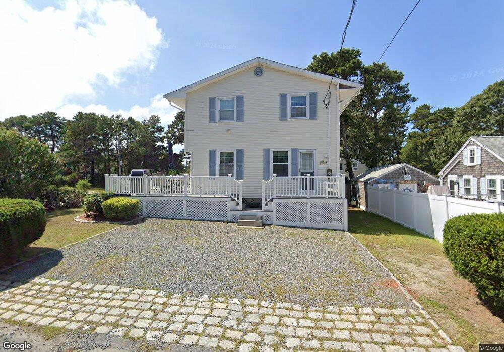
49 Ferncliff Rd Dennis Port, MA 02639
Dennis Port NeighborhoodEstimated Value: $611,000 - $893,000
5
Beds
2
Baths
1,201
Sq Ft
$635/Sq Ft
Est. Value
About This Home
This home is located at 49 Ferncliff Rd, Dennis Port, MA 02639 and is currently estimated at $762,542, approximately $634 per square foot. 49 Ferncliff Rd is a home located in Barnstable County with nearby schools including Dennis-Yarmouth Regional High School and St. Pius X. School.
Ownership History
Date
Name
Owned For
Owner Type
Purchase Details
Closed on
Jan 14, 2000
Sold by
Kadra Kenneth R and Kadra Agnes
Bought by
Hallinan Jeffrey M and Hallinan Lynne
Current Estimated Value
Purchase Details
Closed on
Dec 16, 1988
Sold by
Bonasena Joseph F
Bought by
Kadoa Kenneth R
Create a Home Valuation Report for This Property
The Home Valuation Report is an in-depth analysis detailing your home's value as well as a comparison with similar homes in the area
Home Values in the Area
Average Home Value in this Area
Purchase History
| Date | Buyer | Sale Price | Title Company |
|---|---|---|---|
| Hallinan Jeffrey M | $152,000 | -- | |
| Kadoa Kenneth R | $135,000 | -- |
Source: Public Records
Mortgage History
| Date | Status | Borrower | Loan Amount |
|---|---|---|---|
| Previous Owner | Kadoa Kenneth R | $115,000 | |
| Previous Owner | Kadoa Kenneth R | $95,000 |
Source: Public Records
Tax History Compared to Growth
Tax History
| Year | Tax Paid | Tax Assessment Tax Assessment Total Assessment is a certain percentage of the fair market value that is determined by local assessors to be the total taxable value of land and additions on the property. | Land | Improvement |
|---|---|---|---|---|
| 2025 | $2,698 | $623,200 | $271,500 | $351,700 |
| 2024 | $2,721 | $619,900 | $261,100 | $358,800 |
| 2023 | $2,632 | $563,700 | $237,400 | $326,300 |
| 2022 | $2,402 | $428,900 | $187,100 | $241,800 |
| 2021 | $2,440 | $404,600 | $183,400 | $221,200 |
| 2020 | $2,327 | $381,500 | $183,400 | $198,100 |
| 2019 | $2,398 | $388,600 | $195,200 | $193,400 |
| 2018 | $2,257 | $356,000 | $185,900 | $170,100 |
| 2017 | $2,099 | $341,300 | $171,200 | $170,100 |
| 2016 | $2,002 | $306,600 | $161,400 | $145,200 |
| 2015 | $1,962 | $306,600 | $161,400 | $145,200 |
| 2014 | $1,950 | $307,100 | $151,600 | $155,500 |
Source: Public Records
Map
Nearby Homes
- 37-A Beach Hills Rd
- 22 Ferncliff Rd
- 37 Beach Hills Rd
- 102 Sea St
- 262 Old Wharf Rd Unit 67
- 262 Old Wharf Rd Unit 5
- 262 Old Wharf Rd Unit 5
- 262 Old Wharf Rd Unit 20
- 262 Old Wharf Rd Unit 87
- 241 Old Wharf Rd Unit 82
- 241 Old Wharf Rd Unit 127
- 241 Old Wharf Rd Unit 90
- 402 Old Wharf Rd
- 402 Old Wharf Rd
- 405 Old Wharf Rd Unit B204
- 405 Old Wharf Rd Unit B204
- 217 Old Wharf Rd Unit 64
- 31 Easy St
- 9 Chase Ave Unit 6
- 11 Ocean Park W
- 45 Ferncliff Rd
- 56 Ferncliff Rd
- 53 Ferncliff Rd
- 44 Myrtle Rd
- 54 Ferncliff Rd
- 48 Ferncliff Rd
- 20 Windwood Ln
- 43 Ferncliff Rd
- 57 Ferncliff Rd
- 46 Ferncliff Rd
- 13 Maloney Ln
- 42 Myrtle Rd
- 18 Windwood Ln
- 61 Ferncliff Rd
- 44 Ferncliff Rd
- 60 Ferncliff Rd
- 264 Shad Hole Rd
- 38 Myrtle Rd
- 39 Ferncliff Rd
- 254 Shad Hole Rd