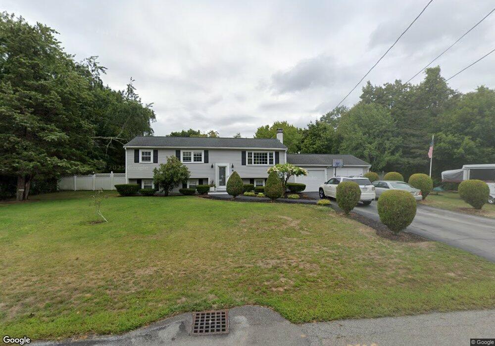
49 King Phillip Ln Hanover, MA 02339
Estimated Value: $698,000 - $721,000
4
Beds
2
Baths
1,756
Sq Ft
$404/Sq Ft
Est. Value
About This Home
This home is located at 49 King Phillip Ln, Hanover, MA 02339 and is currently estimated at $708,969, approximately $403 per square foot. 49 King Phillip Ln is a home located in Plymouth County with nearby schools including Hanover High School and Cardinal Cushing Centers.
Ownership History
Date
Name
Owned For
Owner Type
Purchase Details
Closed on
Oct 6, 2014
Sold by
Toomey William J and Toomey Virginia M
Bought by
Murphy Richard T and Murphy Lori A
Current Estimated Value
Purchase Details
Closed on
Jul 30, 2007
Sold by
Morris Gary L and Morris Maureen E
Bought by
Murphy Matthew D and Murphy Lori A
Home Financials for this Owner
Home Financials are based on the most recent Mortgage that was taken out on this home.
Original Mortgage
$180,000
Interest Rate
6.78%
Mortgage Type
Purchase Money Mortgage
Create a Home Valuation Report for This Property
The Home Valuation Report is an in-depth analysis detailing your home's value as well as a comparison with similar homes in the area
Home Values in the Area
Average Home Value in this Area
Purchase History
We collect this data history from publicly available records. To have your information removed, we recommend requesting removal directly through your county’s website.
| Date | Buyer | Sale Price | Title Company |
|---|---|---|---|
| Murphy Richard T | $162,500 | -- | |
| Murphy Matthew D | $388,000 | -- |
Source: Public Records
Mortgage History
We collect this data history from publicly available records. To have your information removed, we recommend requesting removal directly through your county’s website.
| Date | Status | Borrower | Loan Amount |
|---|---|---|---|
| Previous Owner | Murphy Matthew D | $200,000 | |
| Previous Owner | Murphy Matthew D | $180,000 | |
| Previous Owner | Murphy Matthew D | $25,000 |
Source: Public Records
Tax History
| Year | Tax Paid | Tax Assessment Tax Assessment Total Assessment is a certain percentage of the fair market value that is determined by local assessors to be the total taxable value of land and additions on the property. | Land | Improvement |
|---|---|---|---|---|
| 2025 | $7,142 | $578,300 | $269,600 | $308,700 |
| 2024 | $7,147 | $556,600 | $269,600 | $287,000 |
| 2023 | $6,943 | $514,700 | $245,100 | $269,600 |
| 2022 | $6,553 | $429,700 | $232,800 | $196,900 |
| 2021 | $6,073 | $371,900 | $189,400 | $182,500 |
| 2020 | $6,195 | $379,800 | $200,500 | $179,300 |
| 2019 | $5,821 | $354,700 | $200,500 | $154,200 |
| 2018 | $5,724 | $351,600 | $200,500 | $151,100 |
| 2017 | $5,709 | $345,600 | $199,500 | $146,100 |
| 2016 | $5,522 | $327,500 | $181,400 | $146,100 |
| 2015 | $4,633 | $286,900 | $168,100 | $118,800 |
Source: Public Records
Map
Nearby Homes
- 16 Cervelli Farm Dr
- 51 Cervelli Farm Dr
- 23 Cervelli Farm Dr
- 113 Bradford Rd
- 286 Mayflower Cir
- 250 Main St
- 20 Jackson Rd
- 114 Graham Hill Dr
- 300 Water St
- 28 Lantern Ln
- 392 Cedar St
- 44 Morningside Dr
- 13 Clapp Rd
- 724 Whitman St
- 569 Main St
- 15 Rockland St
- 15 Saddle Ln
- 24 Bowker Ave
- 12 Driftwood Ln
- Lot 5 Princeton Way
- 37 King Phillip Ln
- 61 King Phillip Ln
- 44 Sequoya Ln
- 56 Sequoya Ln
- 30 Sequoya Ln
- 56 King Phillip Ln
- 42 King Phillip Ln
- 25 King Phillip Ln
- 71 King Phillip Ln
- 68 King Phillip Ln
- 32 King Phillip Ln
- 66 Sequoya Ln
- 18 Sequoya Ln
- 115 Myrtle St
- 20 King Phillip Ln
- 43 Sequoya Ln
- 80 King Phillip Ln
- 52 Tecumseh Dr
- 127 Myrtle St
- 55 Sequoya Ln
Your Personal Tour Guide
Ask me questions while you tour the home.