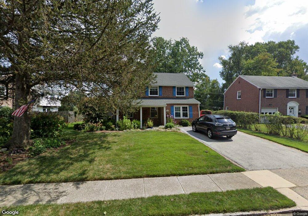
49 Locust Ave Springfield, PA 19064
Estimated Value: $505,600 - $549,000
3
Beds
2
Baths
1,786
Sq Ft
$298/Sq Ft
Est. Value
About This Home
This home is located at 49 Locust Ave, Springfield, PA 19064 and is currently estimated at $532,200, approximately $297 per square foot. 49 Locust Ave is a home located in Delaware County with nearby schools including Springfield High School, St Francis Of Assisi School, and Holy Cross School.
Ownership History
Date
Name
Owned For
Owner Type
Purchase Details
Closed on
Apr 11, 2004
Sold by
Kennedy Anmarie and Johnson Anmarie
Bought by
Kennedy Shawn Michael and Kennedy Anmarie
Current Estimated Value
Purchase Details
Closed on
Mar 4, 2003
Sold by
Kennedy Anmarie and Johnson Anmarie
Bought by
Kennedy Anmarie
Home Financials for this Owner
Home Financials are based on the most recent Mortgage that was taken out on this home.
Original Mortgage
$115,800
Interest Rate
5.3%
Mortgage Type
Purchase Money Mortgage
Purchase Details
Closed on
Jul 2, 1998
Sold by
Kopf Jennie M
Bought by
Johnson Anmarie
Home Financials for this Owner
Home Financials are based on the most recent Mortgage that was taken out on this home.
Original Mortgage
$117,200
Interest Rate
7.04%
Mortgage Type
Purchase Money Mortgage
Create a Home Valuation Report for This Property
The Home Valuation Report is an in-depth analysis detailing your home's value as well as a comparison with similar homes in the area
Home Values in the Area
Average Home Value in this Area
Purchase History
| Date | Buyer | Sale Price | Title Company |
|---|---|---|---|
| Kennedy Shawn Michael | -- | -- | |
| Kennedy Anmarie | -- | -- | |
| Johnson Anmarie | $146,500 | -- |
Source: Public Records
Mortgage History
| Date | Status | Borrower | Loan Amount |
|---|---|---|---|
| Closed | Kennedy Anmarie | $115,800 | |
| Closed | Johnson Anmarie | $117,200 |
Source: Public Records
Tax History
| Year | Tax Paid | Tax Assessment Tax Assessment Total Assessment is a certain percentage of the fair market value that is determined by local assessors to be the total taxable value of land and additions on the property. | Land | Improvement |
|---|---|---|---|---|
| 2025 | $8,023 | $285,460 | $98,520 | $186,940 |
| 2024 | $8,023 | $285,460 | $98,520 | $186,940 |
| 2023 | $7,791 | $285,460 | $98,520 | $186,940 |
| 2022 | $7,559 | $285,460 | $98,520 | $186,940 |
| 2021 | $11,706 | $285,460 | $98,520 | $186,940 |
| 2020 | $5,996 | $132,330 | $47,360 | $84,970 |
| 2019 | $5,856 | $132,330 | $47,360 | $84,970 |
| 2018 | $5,772 | $132,330 | $0 | $0 |
| 2017 | $5,638 | $132,330 | $0 | $0 |
| 2016 | $726 | $132,330 | $0 | $0 |
| 2015 | $741 | $132,330 | $0 | $0 |
| 2014 | $726 | $132,330 | $0 | $0 |
Source: Public Records
Map
Nearby Homes
- 606 W Springfield Rd
- 147 Snyder Ln
- 412 Foster Dr
- 641 W Sproul Rd
- 501 Flora Cir
- 120 W Springfield Rd
- 364 S Rolling Rd
- 29 School Ln
- 249 Gleaves Rd
- 264 Pancoast Ave
- 226 Lynbrooke Rd
- 225 Lynbrooke Rd
- 463 Foulke Ln
- 227 E Leamy Ave
- 412 N Rolling Rd
- 493 Wheatsheaf Rd
- 1291 Country Club Dr Unit Q137
- 1299 Country Club Dr Unit Q141
- 332 Franklin Ave
- 720 Evans Rd
Your Personal Tour Guide
Ask me questions while you tour the home.